Details: Pas de Chevres 
Distance: 7.2 miles (round trip)
near Les Hauderes in The Valais
By: Diane Greer
Hike Facts
- Distance: 7.2 miles (round trip)
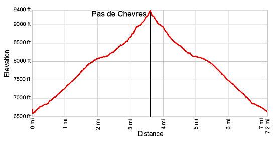
- Elevation: 6,602-ft. - 9,387-ft.
- Elevation Gain: 2,785-ft.
- Difficulty: moderate-strenuous
- Trail Highlights: See Trail Intro
- Basecamp(s): Les Hauderes / Arolla
- Region: The Valais
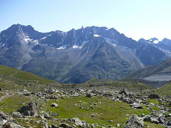
This scenic trail up the beautiful Montagne d’Arolla valley heads to the Pas de Chevres on a rugged ridge with views of the Glacier de Cheilon, Mont Blanc de Cheilon, Le Pleureur and the peaks rising along the east side of the Arolla Valley.
Arolla to Pas de Chevres
In the the small village of Arolla, find the hiking signs on the west side of the town square (across from the postbus stop). Walk southwest toward Pas de Chevres (2-hr 30-min) and Col de Riedmatten (2-hr 40-min).
At the first hairpin curve in the road, about 100 yards from the signpost, leave the road and continue along a track heading south/southwest. Follow the track as it switchbacks up a wooded hillside on moderate grades. At 0.3 miles pass a sign for the trail to Pra Gra and the Aiguilles Rouges branching to the right (north/northwest). Our trail goes left (southwest) toward the Pas de Chevres and Col de Riedmatten.
Follow the trail as it passes a few building and then skirts the north side of the Grand Hotel Kurhaus. Beyond the hotel the trail curves to the left, ascending west/southwest on moderately-steep grades up the Montagne d’Arolla valley. Openings in the trees offer intermittent views of the glaciers spilling down the rugged slopes of the Pigne d’Arolla to the south.
Ignore the trail at 0.6 miles branching left (south) toward the Cabane Vignettes. At 0.75 miles our trail turns left (southwest) on a road. After traveling a short distance along the road reach a trail junction near a restaurant. Turn right (west) toward Col de Riedmatten and Pas de Chevres.
The trail now climbs moderately steep switchbacks through meadows with grand views of Pigne d’Arolla. Mont Colon towers above the head of the Arolla Valley to the southeast. At 1.3 miles the trail curves to the left (southwest) and ascends steeply to meet a dirt road at the signed junction of Remointse d’Arolla at 1.5 miles.
Cross the road and continue traveling southwest on a trail that pass to the right (north) of the photogenic ruins of a few old stone buildings. Signs near the ruins point to Pas de Chevre (1-hr 35-min), Col de Riedmatten (1-hr 30-min) and Barrage Dix (Dix Dam - 4-hr 35-min).
Beyond the ruins the trail heads west/southwest on moderately-easy grades through rocky meadows sprinkled with wildflowers along the base of Mont Dolin and the rugged crags to the north of the trail. Red and white blazes on rocks keep you on track. To the east (behind you) the jagged peaks towering above the east side of the Arolla Valley, including Dent d’Perroc, Pointe des Genevois and Aiguille de la Tsa, fill the skyline. To the south are splendid views of the glaciers cascading down the flanks of the Pigne d’Arolla massif.
Cross a wood bridge over the creek draining the cirque to the north at 2.5 miles. Soon the grade steepens as the trail starts ascending along the north side of the valley. As the path curves to the right (north), views open to the Pas de Chevres, a saddle on the ridge at the head of the valley.
Reach a junction at 3.2 miles. Here the trail to the Col de Riedmatten splits off to the right (north). We turn left (west) climbing steeply up rocky slopes toward the Pas de Chevres. Soon the trail curves to the left (southwest) ascending steep grade through rocky meadows and scree covered slopes. At 3.5 miles the trail turns right (west) and climbs very steep, tight switchbacks to the Pas de Chevres (9,465-ft.) at 3.6 miles. As you climb watch for chamoix, a goat-like antelope, grazing in the meadows around the pass.
The pass enjoys somewhat restricted views of Mont Blanc de Cheilon rising above the Glacier de Cheilon, a river of ice flowing down the flanks of the peak. (Climb above the pass for a better view.) To the west, La Luette, Le Pleureur and Le Sale fill the skyline. Look carefully across the Cheilon Glacier to see the Cabane des Dix (Dix Hut) sitting atop a rocky knob. To the southeast, Mont Collon and the Bouquetins massif dominate the view. On a clear day the top of the Matterhorn graces the horizon.
From the Pas de Chevres, ladders descend about 65-ft. to talus slopes above the lateral moraine along the east side of the Glacier de Cheilon. From there a rocky trail descends the valley along the moraine and then crosses the bed of the retreating glacier to the Cabane des Dix (hut) on the west side of the valley. New ladders and catwalks installed in 2014 now make the descent/climb to the pass easier and safer. Please note the ladders are dangerous when the rungs are wet or icy. Before setting out, check current conditions in Arolla.
Some people are very uncomfortable climbing up and down ladders. If this is the case, consider using the Col de Riedmatten. Be sure to ask about the current condition of the trail descending from the Col de Riedmatten in Arolla before starting the hike. The descent down the west side of the pass is very steep on loose, unstable rock.
For out-and-back hikers, when you are done enjoying the view from the Pas de Chevres retrace your steps to Arolla. Along the way enjoy the great views of the Pigne d' Arolla and the view of the peaks rising along the east side of the Val de Arolla.
Note: Hikers looking for a challenge might want to consider the lollipop loop that visits the Col de Riedmatten and the Pas de Chevres. The clockwise loop descends ladders from the Pas de Chevres to the moraine above the Cheilon glacier, crosses a boulder field and the climbs the Col de Riedmatten. For more information see the Col de Riedmatten hiking description.
Elevation Profile
Driving Directions
From Les Hauderes: From the large parking area in front of the Les Hauderes Post, take the bus bound for Arolla and get off at the Arolla Post, the last stop on the bus. The ride takes about 25 minutes.
Trail Resources
Trail Intro / Trail Photo Gallery / Trail Map
Basecamp(s) Information:
Les Hauderes / Arolla
Region Information:
The Valais
Other Hiking Regions in:
Switzerland