Details: Mattmark to Heidbodme via Jazzilucke 
Distance: 9.6 - 10.8 miles (one way)
near Saas Fee in The Valais
Hike Facts
- Distance: 9.6 - 10.8 miles (one way)
- Elevation: 7,193-ft. - 10,129-ft.
- Elevation Gain: 2,936-ft.
- Difficulty: strenuous-difficult
- Trail Highlights: See Trail Intro
- Basecamp(s): Saas Fee
- Region: The Valais
An great hike traversing two beautiful valleys connected by a challenging, exposed trail traveling between the Jazzilucke and Antrona passes on the Swiss-Italian border.
Mattmark to Jazzilucke
Distance from Trailhead: 4.8 miles (one way)
Ending/Highest Elevation: 10,129-ft.
Elevation Gain: 2,936-ft.
Note: This trail can be hiked in either direction. I recommend walking counter-clockwise from Mattmark to Antrona. This will allow you to get to Jazzilucke (alternative spelling – Jatzilicku) and the most challenging part of the hike earlier in the day. (See the trailhead directions below.)
From the bus stop at the Mattmark Dam, climb the trail to the top of the dam and then walk east on the paved road atop the dam. Along the way enjoy nice views of Monte Moro and the Rothorn rising above the head of the valley. The large expanse of ice visible to the southwest is the Schwarzberg Glacier.
Reach the end of the dam at 0.6 miles. Turn right (south) toward Jazzilucke (3-hr 10-min), Antrona Pass (4-hr 10-min), Heidbodme (6-hr 40-min) and Saas Almagell (8-hr 10-min) on a good gravel trail heading south along the east side of the reservoir.
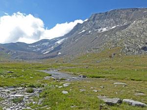
At 1.2 miles reach a junction and turn left (southeast) toward Jazzilucke. The trail climbs up tight, steep switchbacks and then ascends through a rock slide. Beyond the slide the trail continues its steep ascent through meadows, passing a waterfall in-route.
As you climb enjoy ever improving views of the peaks lining the Swiss-Italian border to the south. To the west/southwest the Schwarzberghorn, Strahlhorn and Fluchthorn along with the Schwarzberg Glacier dominate the view.
At 1.5 miles pass a trail branching right toward Dischtealp, located at the head of the dam. Continue straight ahead toward Jazzilucke.
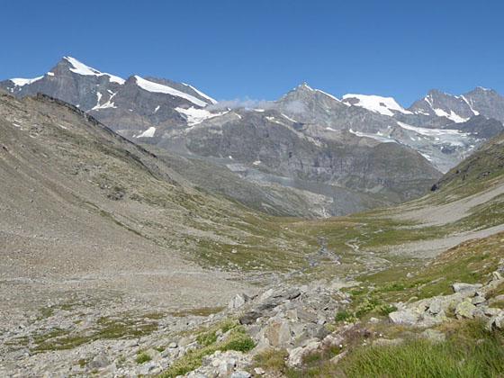
The grade eases at 2.0 miles as the trail curves left (southeast) and enters the Ofental (Ofen Valley), a wide “U” shaped valley clad in pretty meadows. Turn around for great views of the Egginer, Allalinhorn, Taschhorn and the Dom, along with the Strahlhorn and the Fluchthorn to the west of the dam. These views will be with you almost all the way up the valley.
As you ascend the valley pass a second trail branching right toward Dischtealp at 2.3 miles. At 2.7 miles reach a marked junction at Ofutal (8,300-ft.). The trail to the right (south/southwest) leads to Monte Moro Pass on the Swiss-Italian border. Continue straight ahead toward Jazzilucke.
Beyond the junction the trail climbs steeply up a low rise, essentially a stair-step in the valley, and then continues ascending the valley on easy to moderate grades. At 3.3 miles the grade steepens as the trail curves to the northeast, climbing up the valley's south facing slopes toward Jazzilucke Pass. The south face of the Stellihorn towers overhead. To the south are good views of the Spechhorn and the Ofental Glacier.
Reach a trail junction at 3.75 miles. The trail straight ahead leads to Ofental Pass, a small saddle on the ridge at the head of the Ofen Valley. Turn left toward Jazzilucke and Antrona Pass. The trail now climbs steep switchbacks on a diagonal, heading northeast along the south face of the Jazzihorn. Red and white blazed rocks keep you on track.
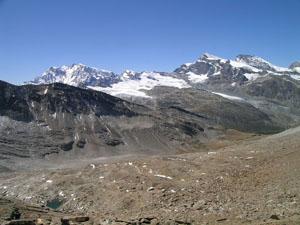
The rocky meadows soon give way to scree covered slopes and views open to the saddle on the ridge to the right (east) of the Jazzihorn, this is our destination. The final push to the pass is very steep, zigzagging up through boulders and loose rock to Jazzilucke/Passo di Cingino (10,108-ft.), atop the ridge on the Swiss-Italian border, at 4.8 miles.
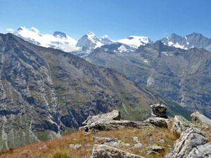
From Jazzilucke the Schwarzberghorn, Strahlhorn, Rimpfischhorn and, in the distance, the Monte Rosa massif dominates the view to the west/southwest. On the Italian (east) side of the pass, sheer rugged slopes drop to a deep valley. The peaks forming the south wall of a large cirque fill the skyline across the valley. On a clear day views extend north toward the Latelhorn rising above Furggtal Valley.
Jazzilucke is a excellent destination and a good turn around point for hikers who are not comfortable on exposed trails or anyone with a fear of heights. It is also a good turn around point if the weather is taking a turn for the worse. Simply retrace your steps to the trailhead at Mattmark Dam for a very scenic and satisfying 9.6 mile round-trip hike.
If the weather is good, I recommend sure-footed hikers with the time and energy continue to Antrona Pass.
Jazzilucke to Antrona Pass
Distance from Trailhead: 5.6 miles (one way)
Ending/Highest Elevation: 9,311-ft.
Elevation Gain: -818-ft.
A sign at the pass points north to Antrona Pass (1-hr), Heidbodme (3-hr 30-min) and Saas Almagell (5-hr). Note: The route between Jazzilucke and Antrona is not recommended for anyone with a fear of heights. It should never be attempted in bad weather or if the trail is covered by ice or snow.
To continue to Antrona Pass, follow the trail as it weaves through large boulders to the east side of the ridge. Here a narrow, exposed trail travels along ledges, clinging to the sheer east face of the Jazzihorn. Fixed ropes and fencing provide a level of security as you navigate the challenging trail. Soon the trail climbs a little and then crosses a boulder field marked with blazes, arrows and metal posts. It is easy to get off track if you are not paying attention. At the end of the boulder field the trail crosses a gully that is often covered in snow. A rope strung across the gully provides a handhold to facilitate the slippery traverse.
Beyond the gully the rocky trail ascends along a bench to the Jazzihorn’s east ridge. The low point on this ridge, extending between the Jazzihorn and the Latelhorn is Antrona Pass. At 5.1 miles the trail starts descending along the ridge crest to Antrona Pass, climbing down rocky slopes and around huge rocky slabs. Red and white markers along with metal posts mark the way.
At 5.5 miles, a descending traverse along a narrow, winding path on the east side of the ridge goes by old stone buildings without roofs. Pass the buildings the trail reaches Antrona Pass (9,311-ft.) at 5.6 miles. The pass was formerly used by mule trains going between Italy and Switzerland. The buildings are believed to be either stables or salt storage sheds.
From the pass enjoy fine views of the peaks forming the ridge along the east side of the Furgg Valley and the Stellihorn to the west. To the southeast views extend to the peaks rimming the south wall of the Troncone Valley in Italy. Beneath the Italian side of the pass the Lago del Cingino (Lake Cingino) lies in a rugged bowl.
Antrona Pass to Heidbodme
Distance from Trailhead: 10.8 miles (one way)
Ending/Highest Elevation: 7,698-ft.
Elevation Gain: -2,000-ft.
After taking a break, follow the trail dropping down the west side of the pass toward Furggstalden and Heidbodme. At 5.8 miles reach at large boulder with an arrow point left toward Furggu (Furggstalden) and right toward Heidbodme. The trail from Antrona to Furggstalden drops to the valley floor and then descends through pretty meadows, losing over 3,000-ft in 5.2 miles. See the Antrona Pass trail description for more information.
The new trail from Antrona to Heidbodme travels along the valley’s northwest wall, rising and falling to circumvent ridges and landslides. Sections of the trail are prone to rock slides and may be exposed and/or covered in loose rock. Over the 5.2 miles the trail loses a little over 2,000-ft. and climbs about 500-ft. At Heidbodme there is a chair lift that descends to the Furggstalden area where you catch a second chair lift to Saas Almagell.
If you are tired and/or pressed for time the route to Furggstalden is the best bet. If you have the time and energy then select the trail to Heidbodme, which has the best views but involves some climbing and sections of exposed trail, which makes it more strenuous and difficult. For more information see the Antrona Pass via Furggstalden and Antrona Pass via Heidbodme hikes. The mileage and elevation profile for this hike assumes you return via Heidbodme.
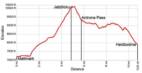
Elevation Profile
Driving Directions
From Saas Fee to Mattmark: Obtain a bus ticket from Saas Fee to Mattmark, a large dam at the head of the Saastal Valley. Take the bus heading toward Saas Grund/Brig. At Saas Grund, change for the bus heading south toward Mattmark and get off at the last stop at the dam.
Return directions from Furggstalden (Saas Almagell) to Saas Fee: Take the Furggstalden lift down to Saas Almagell and then follow the signs to the post bus stop. Get on a bus bound for either Saas Fee or Saas Grund. If you are on a Saas Grund bus, change at Saas Grund for a bus going to Saas Fee. (During busy times in the summer extra buses are run that do not follow the typical routes. Always check the front of the bus to see its ultimate destination.) For more information on the chairlift see the Saas Fee Lift Schedule and look at the section labeled Saas-Almagell.
Return directions from Heidbodme (Saas Almagell) to Saas Fee: At Heidbodme, purchase a ticket for the two stage lift to Saas Almagell. Take the Heidbodme Sesselbahn (chair lift) and then walk north, following the signs to the Furggstalden Sesselbahn (chair left) in Furggstalden. The walk is a little over a quarter mile long. Take the Furggstalden lift down to Saas Almagell and then follow the signs to the postbus stop. Get on a bus bound for either Saas Fee or Saas Grund. If you are on a Saas Grund bus, change at Saas Grund for a bus going to Saas Fee. (During busy times in the summer extra buses are run that do not follow the typical routes. Always check the front of the bus to see its ultimate destination.) For more information on the lifts see the Saas Fee Lift Schedule and look at the section labeled Saas-Almagell.
Trail Resources
Trail Intro / Trail Photo Gallery / Trail Map
Basecamp(s) Information:
Saas Fee
Region Information:
The Valais
Other Hiking Regions in:
Switzerland