Details: Plattjen to Saas Fee (Gemsweg Part 2) 
Distance: 3.9 miles (one way)
near Saas Fee in The Valais
By: Diane Greer
Hike Facts
- Distance: 3.9 miles (one way)
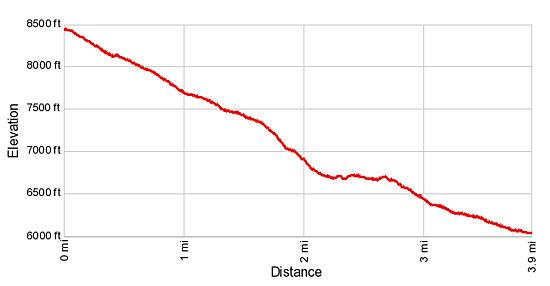
- Elevation: 8,447-ft. - 5,854-ft.
- Elevation Gain: -2,593-ft.
- Difficulty: moderate
- Trail Highlights: See Trail Intro
- Basecamp(s): Saas Fee
- Region: The Valais

Great views of the Mischabel peaks towering above Saas Fee and the Saas Valley are the highlights of this short trail descending from Plattjen to Saas Fee along the Gemsweg.
Plattjen to Saas Fee
Take the gondola from Saas Fee to Plattjen. (See trailhead directions below.) Upon exiting the lift walk behind the restaurant, heading southeast on a track that ascends a short distance to an overlook with wonderful panoramic views. Looking west from the overlook a wall of 13,000-ft. (4,000-meter) peaks in the Mischabel Range, including the Taschhorn, Dom and Lenzspitze, dominate the view. To the east the peaks rising along the Saastal (Saas Valley) fill the skyline. To the north views extend up the Saas Valley to the distinctively shaped Bietschhorn (the triangular peak) and nearby summits of the Bernese Alps.
To start the hike, return to the sign post behind the lift station. Here the Gemsweg heads west in the direction of the Plattjen Berghaus (20-min), Gletschergrotte (1-hr 15-min), Hannig (3-hr 5-min) and Saas Fee (1-hr 30-min). Soon the trail turns northwest and descends through rocky meadows on a series of moderately-steep switchbacks with terrific views of the Mischabel Range. After walking about 0.4 miles take a detour to the ridge to the right (east) of the trail for stunning views of the Saastal.
Reach the Plattjen Berghaus and the Restaurant V at 0.7 miles. Beyond the Berghaus, the trail descends a series of tight, steep switchbacks that end at 0.9 miles. From this vantage point enjoy lovely views of Saas Fee and the Saastal Valley.
The trail now curves to the left (west/southwest) and reaches a trail junction at 1.1 miles. Ignore the broad track to the right which makes a “U” turn and drops down to Saas Almagell and instead continue straight ahead. A short distance beyond pass a trail branching right (northwest) that descends steep switchbacks to Saas Fee. We continue heading southwest, passing to the right of a small cement building with signs pointing straight ahead toward the Gemsweg (Gletschergrotte, Thrift and Hannig).
Follow the trail as it descends on moderate grades through pretty meadows sprinkled with wildflowers. Along the way enjoy fine views of the peaks and glaciers of the Mischabel Range towering over the west side of Saas Fee and the Saas Valley to the north. Below are good bird’s-eye views of Saas Fee.
Soon the meadows give way to low lying shrubs and scattered larches. At 1.6 miles the path starts dropping down a series of steep switchbacks beneath sheer rock slopes, passing a few pretty waterfalls. Fixed ropes along sections of the trail provide a level of security on steep sections that could be problematic if wet or covered with ice. As you descend, pass a trail junction where you continue straight ahead on the Gemsweg.
The grade abates as the path enters a larch forest at 2.1 miles. The easy walking is short lived. Soon the trail drops steeply down a wooded hillside and curves to the right (northwest) as it crosses a bridge over a raging torrent of meltwater from the Fee Glacier. On the other side of the bridge the trail ascends a forested hillside, crosses a ski run and then reenters the trees, traveling through an undulating landscape.
Cross a bridge over another stream at 2.7 miles. Beyond the second bridge the trail reaches an area where several gravel roads converge. These roads are used by mountain bikes and are best avoided when possible. My advice is to travel along the road heading toward the Café Gletschergrotte for a short distance. Before arriving at the café reach a junction where you turn right on a trail toward Saas Fee (35-min).
There are now several routes heading back to Saas Fee. The best option is to watch for a trail to the left that drops down to a glacial lake. Reach at “T” intersection near the lake and turn right, following the trail as it crosses the lake's outlet stream and then curves around the base of a small hill to the pastures to the south of Saas Fee. In the pastures broad walkways lead back the main street in Saas Fee at 3.9 miles.
If you miss the turn for the trail heading down to the lake, the trail you are on soon rejoins the road where it crosses the stream. Follow the road as it drops down to the pastures to the south of Saas Fee. Here broad walkways head northeast toward the town, meeting the main street at 3.9 miles.
For a longer, more challenging hike, combine this hike with the reverse of the Hannig to Saas Fee hike. To continue the hike to Hannig, follow the signs near the Café Gletschergrotte pointing toward Hannig along the Gemsweg trail.
Elevation Profile
Driving Directions
From the Saas Fee Bus Terminal to the Plattjen Gondola: Walk southwest along the Postplatz, past the Post Office. Take Stadelweg, the street heading southwest that drops steeply down the hill, passing some old wood building along the way. Signs point to the Alpin Express and the gondola to Plattjen.
At the “Y” intersection, bear left (south) on Panoramastrasse (Panorama Street). Follow the road as it crosses the bridge over the Fee-Vispa River and then curves to the southwest, skirting the west side of the Alpin Express Station.
Beyond the lift, the road joins with Mischiweg Strasse, which dead ends at Gletscherstrasse (Glacier Street). Turn left on Gletscherstrasse and travel along the road a short distance to the Plattjen lift Station. Sign along the way pointing to the Plattjen lift should keep you on track.
Trail Resources
Trail Intro / Trail Photo Gallery / Trail Map
Basecamp(s) Information:
Saas Fee
Region Information:
The Valais
Other Hiking Regions in:
Switzerland