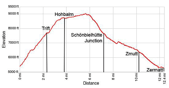
Hike Facts
- Distance: 7.6 - 12.3 miles (loop)
- Elevation: 5,325-ft. - 9,016-ft.
- Elevation Gain: 2,342-ft. - 3,691-ft.
- Difficulty: strenuous
- Trail Highlights: See Trail Intro
- Basecamp(s): Zermatt
- Region: The Valais
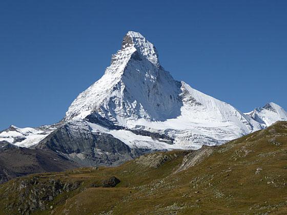
Our favorite hike in Zermatt features magical views of the majestic Matterhorn and stunning panoramas of the 4,000-meter peaks towering above the Zermatt area.
Trailhead to Trift

Distance from Trailhead: 2.3 miles (one way)
Ending/Highest Elevation: 7,667-ft.
Elevation Gain: 2,352-ft.
The Hohbalm hike begins at the corner of Chrum and Bahnhofstrasse (the main street), a quarter mile south of the train station (Bahnhof), in Zermatt. (See directions below.) Start walking uphill on Chrum, a narrow alley. Signs a short distance up the alley indicate you are on Chrum and point toward the Trift, Alterhaupt, Hohbalm and Arbenbach trails.
Bear left where the alley splits and about 500-ft. further along turn left onto Triftweg, a paved walkway. (Look for a blue metal Triftweg sign embedded in the stone wall along the right side of the pavement.) The steep walkway initially climbs south but soon curves to the right (north/northwest) at the corner of the Omnia Hotel. Past the hotel the path turns into a dirt track ascending through meadows with nice views of Zermatt.
The trail now climbs toward the Trift Gorge, the obvious cleft in the hillside carved by the waters of the Triftbach. Pass trail junctions at 0.3 miles and 0.5 miles. At each intersection continue in the direction of Trift and Alterhaupt (Edelweiss). Note: Ignore signs pointing to an alternative route climbing the Hohbalm. In my opinion the trail to Trift is the better hike with superior scenery.
After a slight bit of downhill cross the Triftbach on a good wooden bridge and then ascend to join a track coming up from town. Turn right at the signed junction toward Alterhaupt (Edelweiss), Trift and the Hohbalmen, a popular viewpoint on the Hohbalm plateau.
Follow the trail as it climbs switchbacks through a forest of larch and fir trees, leaving the river briefly to circumvent a large rock outcropping. Arrive at the Alterhaupt (6,345-ft.) and the Café Edelweiss at 0.9 miles. This beautiful overlook enjoys bird’s-eye views of Zermatt and nice vistas of the Mattertal (Matter Valley) along with the Dom (14,911-ft.) and the Taschhorn (14,733-ft.) to the northeast.
Just beyond the restaurant the track splits. The trail to the left signed for Hohbalmen (2-hr) and Arbenbach (3-hr 40-min) is a shorter and steeper route to the Holbalm plateau that is not recommended since it misses some spectacular scenery. Our trail toward Trift (1-hr 10-min) and the Wisshorn (3-hr 10-min) continues straight ahead up the gorge, ascending slightly before dropping gently down to the river (Triftbach).
When the trail reaches the river it resumes its ascent up the gorge, crossing a bridge to the right (north) side of the Triftbach at 1.5 miles. As you climb, periodically turn around for good views of the Oberrothorn and the Monte Rosa massif across the Mattertal to the southeast.
During late July and early August the meadows along the gorge feature an impressive display of wildflowers. Signs along the way identify the flowers and describe their unique habitat. Keep an eye out for the elusive Edelweiss with its delicate white petals.
Not far beyond the bridge views open to the Wellenkuppe’s (12,805-ft.) snow covered summit rising above the head of the Trift Valley. With each step the views improve and soon the pyramid-shaped Ober Gabelhorn (13,330-ft.) joins the scene followed by the rugged crags of the Unter Gabelhorn (11,125-ft.).
Reach the Hotel du Trift (7,667-ft.) at 2.25 miles. The hotel, situated in a lovely alpine valley at the head of the gorge, is surrounded by a gorgeous cirque of high peaks and glaciers. Views (from right to left) encompass the Zinalrothorn (13,848-ft.), Trifthorn (12,230-ft.), Wellenkuppe, Ober Gabelhorn, Mittel Gabelhorn and Unter Gabelhorn. The Trift and Gabelhorn glaciers along with numerous snow fields adorn the flanks of the peaks. Turn around for equally impressive views of the Monte Rosa massif rising above Gornergrat (Gorner Ridge) to the southeast.
This is a great spot for a break and to contemplate the next phase of your ascent to the Hohbalm. The Trift Hotel provides 30 dormitory spaces and 9 private rooms along with beverages, snacks and meals. Picnic tables in front of the hotel offer a front row seat to the panorama of peaks rising above the valley. Alternately, find a nice spot in the meadows to the west of the hotel to enjoy a picnic lunch and the terrific views.
Trift Hotel to Hohbalm Viewpoint

Distance from Trailhead: 3.8 miles (one way)
Ending/Highest Elevation: 8,750-ft.
Elevation Gain: 3,425-ft.
Just beyond the hotel signs point right to the trail leading to the Wisshorn (2-hr) and the routes to the Rothhornhutte (2-hr 30-min), Platthorn (3-hr 5-m) and Mettelhorn (3-hr 40-min). Another group of signs point left toward the Hohbalmen (1-hr 5-min) and Schonbielhutte (4-hr 10-min). To your left the Hohbalm trail is clearly visible climbing the steep grassy hillside forming the valley’s south wall.
To continue the hike turn left (west) toward the Hohbalmen. The trail wanders through the meadow, crossing the nascent Thriftbach on a wood bridge. Beyond the bridge the path curves to the left (south) and begins a moderately steep ascending angling up the valley’s south wall.
As you climb enjoy ever improving views of the cirque at the head of the Trift valley. To the northeast the Dom, Taschhorn and Alphubel soar above the Mattertal.
At 3.25 miles the grade abates as the trail curves to the right (west). As you crest the hill, reaching the high alpine meadows of the Hohbalm plateau, the Matterhorn burst onto the scene. No matter how many times I hike this trail I'm still surprised and delighted by the view.
The worst of the climb is now over and it is time to enjoy the fruits of your hard work. The Hohbalm plateau, located 3,400-ft. above the Zermatt valley, offers phenomenal views in all directions. To the south the Matterhorn’s distinct east and north faces command your attention. A massive wall of 4,000 meter peaks, including the Breithorn (13,665-ft.), Pollux (13,425-ft.), Castor (13,864-ft.), Lyskamm (14,852-ft.) and the Monte Rosa massif (15,203-ft.) fill the skyline to the southeast. To the east the Oberrothorn towers above the Findel Valley. The Mischabel Range, with the Dom and the Taschhorn, dominate the view the northeast.
These marvelous views, from different perspectives, will be your constant companion for the next 2.8 miles as the trail traverses the Hohbalm plateau, a broad shoulder extending from the Unter Gabelhorn’s southeast ridge. Follow the trail as it heads southwest, gently ascending broad grassy slopes dotted with tiny wildflowers.
Views soon open to the Findel Glacier to the east. The glacier starts on the slopes of the Cima di Jazzi (12,477-ft.) on the Swiss-Italian border and flows west between the Strahlhorn and Rimpfishhorn, to the north, and the Stockhorn, to the south.
At 3.8 miles reach a trail junction at Hohbalmen, a wonderful viewpoint (8,750-ft.). Here a signs point left (southeast) to Alterhaupt (1-hr 05-min) and Zermatt (1-hr 45-min) and straight ahead (southwest) toward Arbenbach (1-hr 40-min) and Schonbielhutte (3-hr). The junction is a popular lunch spot and a good place to turn around if you want a shorter hike.
If you decide to turn around at this point there are two options. We recommend simply retracing your steps to Zermatt via the Trift Gorge for a very satisfying 7.6 mile day. Alternatively you can take the trail to the left towards Alterhaupt. The narrow path drops very steeply to Alterhaupt where it rejoins the trail down the Trift Gorge to Zermatt for a 6.5 mile round trip hike.
Complete the Loop

Distance from Trailhead: 12.3 miles (loop)
Ending/Highest Elevation: 9,016-ft.
Elevation Gain: 3,690-ft.
If time, energy and the weather permit we recommend crossing the Hohbalm plateau toward Arbenback and Schonbielhutte (Schonbiel Hut). Beyond the viewpoint the trail follows a gentle ascending traverse toward the Matterhorn, gradually bearing right (west/southwest) along a narrow shoulder below the Unter Gabelhorn.
This portion of the trail offers numerous lunch spots with stunning, front row seats with views of the Matterhorn. The Findel Glacier and its surrounding peaks fill the skyline to the east while the snowcapped peaks between Monte Rosa and the Breithorn dominate the view to the southeast. At 4.2 miles the trail curves to the right (west) around a grassy outcropping and views open to the Tiefmatten and Stockji glaciers spilling down the cirque at the head of the Zmutt Valley.
At 5.0 miles the path heads west along grassy slopes beneath the south face of the Unter Gabelhorn, crossing occasional rock slides and avalanche chutes. The trail is narrow in spots and may feel a bit exposed but is quite safe.
Reach the high point of the trail (9,015-ft.) at 5.8 miles. The trail initially descends west on moderately easy grades for 0.2 miles to a broad grassy knoll directly across from the Matterhorn’s north face, another great overlook. Past the overlook, the path drops on moderately steep grades toward the Arben Valley. Along the way views open to the Arben Glacier nestled beneath the Ober Gabelhorn and Mont Durand rimming the head of the Arben Valley.
At 6.6 miles the trail turns to the left (south) and steeply descends the east side of the Arben valley on long switchbacks with wonderful views of the Matterhorn and the peaks rising above the head of the Zmutt Valley. Reach the junction with the trail branching right (west/southwest) to Schonbielhutte at 7.2 miles. We turn left (east) toward Chalbermatten, Zmutt, Furi and Zermatt.
The trail descends on moderately-easy grades for a short distance along the left side of a small stream before curving around and dropping down a gully on a series of tight, moderately steep switchbacks, passing a photogenic waterfall at 7.4 miles.
At the bottom of the falls the trail briefly travels beside cliffs along the valley’s north wall before arriving at a trail detour. (The original trail was wiped out by a rockfall and the area is still unstable.) Turn right (southeast) at the detour and follow the rerouted trail as it descends through larch trees, passing a somewhat confusing sign for a route to Zermatt and Furi branching off to the right. Ignore this trail and continue straight ahead in the direction of Chalbermatten, Zmutt and Zermatt.
At 8.0 miles reach a bridge crossing the Zmuttbach (Zmutt River). Do not cross the bridge but instead go left (east/northeast), following the trail as it drops around the bottom of the landslide and then climbs steep, dusty switchbacks to the continuation of the main trail at 8.5 miles.
A good path now descends steadily, heading east through meadows to Chalbermatten (6,906-ft.), the site of a defunct restaurant, at 9.0 miles. The Findel Glacier, Riffelalp and Gornergrat dominate the view to the east.
Beyond Chalbermatte the trail continues it moderate descent, passing above the Zmutt reservoir and then traveling through pastures to Zmutt at 10.2 miles. The small village is a popular lunch spot and a favorite destination for tourist seeking a short walk from Zermatt. (See the Zmutt Loop hike for more information.)
The remainder of the hike follows a popular trail descending along a wide, pleasant track that pass some old buildings and grain storehouses. At 10.6 miles the trail drops steeply down a few switchbacks and then curves left (northeast) as it heads back to Zermatt.
Reach the south end of Zermatt at 11.9 miles. From here you can either hop on an electric shuttle bus (fee required) or walk 0.4 miles through town to the start of the trail for a 12.3 miles hike. (When in doubt, follow signs pointing to the Zermatt Bahnhof.)
Elevation Profile
Driving Directions
From the Zermatt Bahnhof (Train Station): Walk south on Bahnhofstrasse, the main street, for 0.25 miles and turn right on Chrum, a small alley. Chrum is the first street on the right after the Mont Cervin Hotel (left).
From the Church in Zermatt: From the south end of town, walk to the church at the corner of Kirchstrasse and Bahnhofstrasse. Walk 0.15 miles (820-ft.) north on Bahnhofstrasse and turn left on Chrum, a small alley. Chrum is the first street on the left after the Hotel Monte Rosa.
Note: The Unique Hotel Post is located across from Chrum street. Gees Cockoo Club, with Grampi’s on the second floor, is located at the southeast corner of Bahnhofstrasse and Chrum.
As you head up the alley you will see signs indicating you are on Chrum and pointing toward the trails to Trift, Alterhaupt, Hohbalm and Arbenbach. At 0.1 miles the alley splits. Bear left at the split and about 500-ft. further along turn left onto Triftweg, a paved walkway, marked with a blue metal sign embedded in the stone wall running along the right side of the street. Follow the hiking directions above.
Trail Resources
Trail Intro / Trail Photo Gallery / Trail Map
Basecamp(s) Information:
Zermatt
Region Information:
The Valais
Other Hiking Regions in:
Switzerland