Hike Facts
- Distance: 5.6 - 10.5 miles (round trip)
- Elevation: 8,490-ft. - 10,695-ft.
- Elevation Gain: 2,205-ft.
- Difficulty: strenuous
- Trail Highlights: See Trail Intro
- Basecamp(s): Zermatt
- Region: The Valais
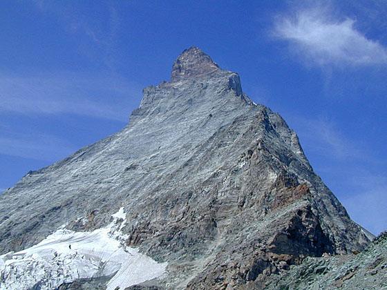
The short, steep hike to Hornlihutte offers a unique, up-close opportunity to experience the iconic Matterhorn from the base of the most popular climber’s route to the summit.
Hornlihutte with Return to Schwarzsee or Zermatt

Note: This description of the Hornlihutte (Hornli Hut) trail starts atop the Matterhorn Plateau at Schwarzsee, reached by taking the Matterhorn Paradise / Schwarzsee Gondola. If you choose to walk from Zermatt to Schwarzsee add four to five miles (depending on the route) and 3,100-ft. in elevation gain to the hike. (See the directions to the trailhead for more information.)
Schwarzsee (8,490-ft.), a popular viewpoint, sits beneath the Matterhorn’s northeast ridge known as the Hornligrat – considered to be the easiest route to the summit. Looking up from the viewpoint visitors are treated to expansive views of the Matterhorn’s east and north faces. Hornlihutte, the base camp for climbers tacking the Hornligrat, is clearly visible at the base of the ridge.
The viewpoint also enjoys panoramic views of Monte Rosa (15,203-ft.), Lyskamm (14,852-ft.) and the Breithorn (13,665-ft.) to the southeast. The Mischabel Range, with its two highest peaks -- the Dom (14,911-ft.) and the Taschhorn (14,733-ft.), along with the Findel Glacier fill the skyline to the northeast while Dent Blanche (14,291-ft.) and the Ober Gabelhorn (13,330-ft/4,063-meters) massif dominate the view to the northwest. These marvelous views will only get better on your climb to the hut.
When you are done taking in the views find the trail signs near the Hotel Schwarzsee. Walk southwest on the broad track toward Hirli (40-min), Hornlihutte (2-hr 10-min) and Trockener Steg (2-hr 15-min). The trail ascends a grassy bench on moderate grades, curving around and above Schwarzsee Lake and its pretty little chapel.
The grade abates briefly as the path crosses a bench and a small gully before resuming its steep ascent on switchbacks up the hillside. As you crest the hill the rocky meadows give way to talus slopes.
The trail now heads west, passing under a ski lift at 0.9 miles and then ascends along a cliff face beneath Hirli (9,478-ft.), the rocky knob at the end of the Matterhorn’s east ridge. Past the junction with the trail to Trockener Steg, metal stairs and cantilevered walkways bolted to the sheer rock face provide safe passage for hikers where the trail has eroded and fallen away.
Back on solid ground the trail climbs moderately steep switchbacks up a rocky cliff face to the top of the ridge at 1.4 miles. Atop the ridge, follow the trail ascending southwest on moderately grades for half a mile. Along the way pass a trail branching right and dropping down to Stafelalp and Zermatt.
At 1.9 miles the trail starts ascending very steep switchbacks up a knife edge ridge to the hut, gaining more than 1,000-ft. over 0.8 miles. Fixed ropes along the way provide a level of security on extremely steep and/or exposed trail segments that could be problematic when covered with snow and ice.
Reach the recently rebuilt Hornlihutte (10,695-ft.) at 2.7 miles. After viewing the Matterhorn from afar it is truly amazing to stand this close to the majestic peak soaring above the hut. For even better views walk a short distance up the ridge beyond the hut to where the climbing route starts. With binoculars it is possible to see climbers on the Hornligrat ridge.
The hut and the shelf where it resides offer marvelous views of the surrounding summits. Across the valley to the north a wall of 4,000-meter peaks, from Dent Blanche to the Weisshorn, fill the skyline. The Mischabel Range rises above Zermatt to the northeast. To the southeast an incredible spectacle of peaks and glaciers along the Swiss-Italian border, including Monte Rosa, Lyskamm and the Breithorn, command your attention. Nearer at hand to the west is the Matterhorn Glacier, clinging to the rugged slopes along the peak’s north face.
After enjoying the views, retrace your steps to Schwarzsee. Here you can either ride the gondola back to Zermatt for a 5.6 mile round-trip hike or walk back to Zermatt. To hike back to Zermatt find the signpost near the Schwarzsee Hotel. Here signs point to two routes descending to Zermatt. The trail leading to Hermettji, Furi and Zermatt is, in my opinion, the nicest. Another route drops down to Zermatt via Furgg and Furi.
From Schwarzsee both the trails head east on a broad track through meadows for 0.3 miles to a junction where the tracks diverge. The trail to Furgg turns right (south), descending on a dirt road to Furi. The trail to Hermetje continues straight ahead on a descending traverse through meadows and then switchbacks down steep forested slopes to Furi. I prefer this option since it has better views and keeps you off the roads. The trail to Furgg is not quite as steep but requires you to watch for bikes whizzing down the road.
From Furi, follow the signs toward Zum See, a small hamlet with traditional wooden structures and a small chapel. Beyond Zum See the path crosses a bridge to the west bank of the Zmuttbach and then follows the well beaten path back to the Schwarzsee lift station in Zermatt. Total hiking distance from Schwarzsee to Zermatt is 4.4 to 4.9 miles depending on the route. Total round trip distance from Schwarzsee to Hornlihutte to Zermatt is 10.0 to 10.5 miles, again based on the route.
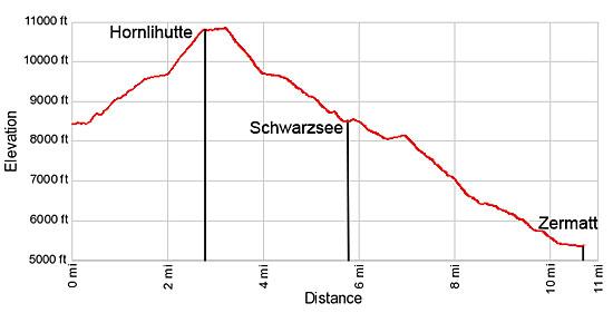
Elevation Profile
Driving Directions
Walking Directions from the Zermatt Bahnhof (Train Station) to the Schwarzsee Lift Station: Walk south/southwest on Bahnhofstrasse, the town’s main street, for 0.3 miles and then turn left onto Kirchstrasse (Church Street). You will pass the Matterhorn Museum on the left just before the turn. The Pfarrkirche St. Mauritius (church) is located on the southeast corner of Bahnhofstrasse and Kirchstrasse.
Walk down Kirchstrasse for 0.1 miles, crossing the bridge over the river, and then turn right on Schluhmattstrasse (Schluhmatt Street), the first street past the river. Follow Schluhmattstrasse for 0.4 miles to the Matterhorn Glacier Paradise / Schwarzsee Gondola Station. Purchase a ticket to Schwarzsee. For more information see Schwarzsee Information on the Matterhorn Paradise lift pages.
Hiking to Schwarzsee: Walking from the lift station to Schwarzsee adds 4.0- to 5.0-miles (depending on the route) and over 3,100-ft. in elevation gain to the hike. To walk from the bottom of the Schwarzsee lift station, follow the yellow trail signs for Blatten, Zum See, Furi and Schwarzsee. The trail ascends through trees and meadows to Schwarzsee on the Matterhorn plateau. The section of the trail from Zermatt to Furi walks under or near the gondola. Beyond Furi, a mid-station for the gondola, the route enjoys some nice views of the Gorner Glacier Garden area.
Trail Resources
Trail Intro / Trail Photo Gallery / Trail Map
Basecamp(s) Information:
Zermatt
Region Information:
The Valais
Other Hiking Regions in:
Switzerland