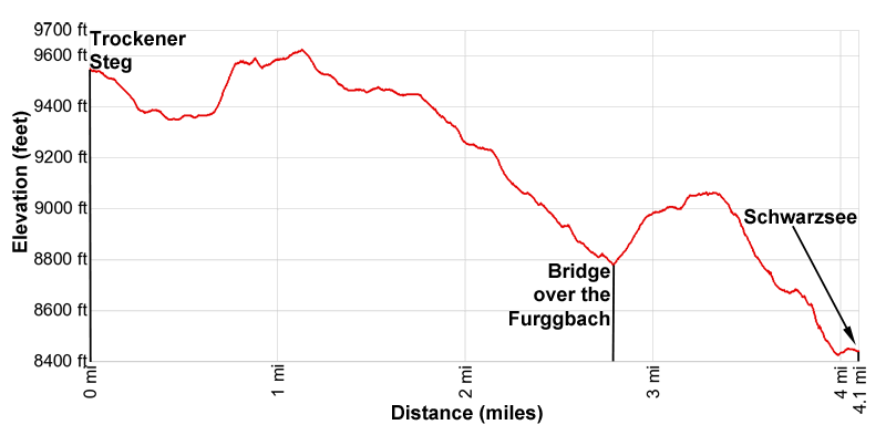
Hike Facts
- Distance: 4.1 miles (one way)
- Elevation: 9,565-ft. - 9,625-ft.
- Elevation Gain: 565-ft.
- Difficulty: moderate
- Trail Highlights: See Trail Intro
- Basecamp(s): Zermatt
- Region: The Valais
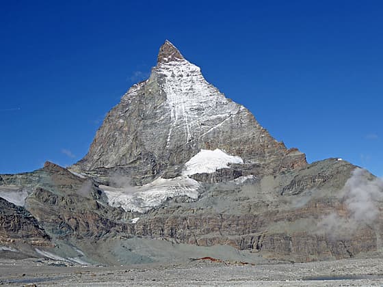
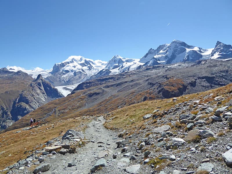
Stunning, panoramic views of the Matterhorn and the summits rimming the Zermatt area are the highlights of this scenic hike through the stark landscape left by retreating glaciers. En route pass glacial lakes, colorful rock outcroppings and learn about the local geology.
Matterhorn Glacier Trail
Note: The elevation gain/loss for this hike is +565-ft. / - 1650-ft. (172-meters / -502-meters)
The day starts by taking the Schwarzsee gondola to Trockener Steg. (See trailhead directions below.) From Zermatt the gondola travels through intermediate stations at Furi, Schwarzsee and Furgg before arriving at Trockener Steg. The doors of the gondola will open at these stations to allow people to get on and off. Stay seated on the gondola until you arrive at Trockener Steg.
At Trockener Steg exit the gondola station. With your back to the station descend south down a broad, steep track to a cement building (about 300-ft /90-meters). Attached to the building you will see a small sign for the Matterhorn Glacier Trail pointing right (west/northwest) to a broad track dropping down to the Theodulgletschersee (Theodul Glacier Lake), a large lake. A red and white striped marker is found below the sign. For the remainder of the hike watch for these red and white markers on rocks along with red and white stripped poles to stay on the trail.
Descend the track on moderate to moderately-steep grades accompanied by grand views of the east face of the Matterhorn. To the left (south) the Theodul glacier spills down the slopes of Theodulhorn and the Furgghorn. The summits of the Zinalrothorn, Wellenkuppe and Ober Gabelhorn dominate the view to the north.
Reach the lake at 0.3 miles (0.5 km). On a calm day the Matterhorn is beautifully reflected in the still waters. Here the trail turns right (north) and traverses above the east side of the lake, traveling through the barren, rocky landscape left by the receding Theodul and Furgg glaciers.
Soon the path curves to the left, swinging around the north end of the lake where it crosses a wood bridge over the outlet stream. Turn around for views of the Klein Matterhorn and Breithorn rising to the southeast. Beyond the bridge the trail curves to the left around the west side of the lake. Here views to the north expand to include Weisshorn.
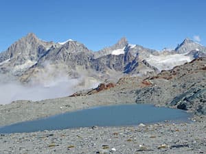
Near the southwest end of the lake the trail makes a short, steep climb to a bench, studded with small lakes, at 0.75 miles (1.2 km). As you crest the bench turn around for grand views of the peaks rising to the northeast including the Dom, the Taschhorn, the Rimpfischhorn and the Strahlhorn.
Atop the bench the path turns right (west/northwest), following an undulating course through striking red rock outcroppings and glacial deposits. To the south are more good views of the Theodulhorn, the Furgghorn and the Theodul glacier.
At 0.9 miles (1.4 km) the path reaches a junction and the first of several lakes along the bench. Here a route branches left (south) toward Gandegghutte and Theodulpass. Take a brief detour along to the lake for reflections of the Matterhorn and panoramic views that stretch northeast from the Dom to the Breithorn.
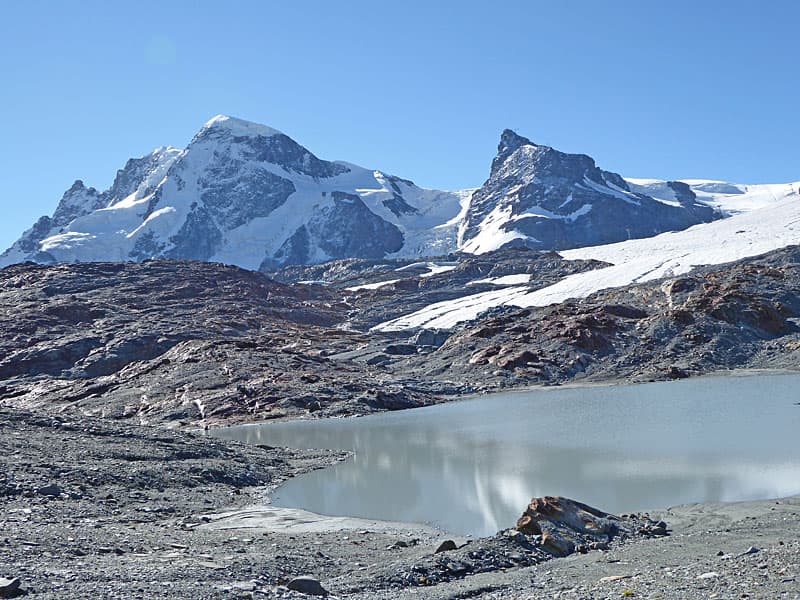
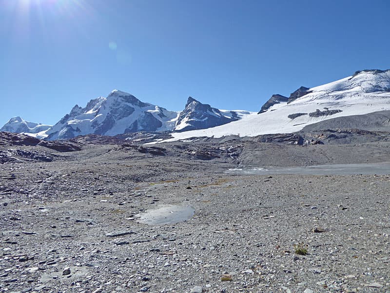
After enjoying the views, continue along the signed Matterhorn Glacier Trail toward Hirli and Schwarzsee. The path now passes a succession of lakes as it travels through the barren landscape. The Matterhorn fills the skyline to the west. Behind you, to the east, views extend from the Klein Matterhorn to Monte Rosa and the massive Gorner Glacier. To the north the serrated profiles of the Weisshorn, Zinalrothorn and the Ober Gabelhorn dominate the view.
The trail hits the high point of the hike at 1.1 miles (1.8 km) and then curves to the right (northwest) an it descends to a lower bench at 1.3 miles (2.1 km). Here the Matterhorn towers over the Furggsee, a large lake, fed by glacial meltwater.
The path soon curves to the left (west), traveling high above the north side of the lake and its inlet streams. Turn around (east) for more views stretching from the Klein Matterhorn to Monte Rosa. You are now close enough to the Matterhorn to see Hornlihutte, a hut situated at the foot of the peak's northeast ridge (Hornli Ridge), a famous climbing route to the summit.
At 1.7 miles (2.7 km) the trail begins descending. The path soon curves to the right (north/northwest) as it drops on moderate to steep grades down rugged slopes and the remains of the eastern lateral moraine of the Furgg Glacier. Pay close attention to trail markers, posts and cairns marking the trail down rocky switchbacks. The Matterhorn looms overhead. The toe of the Furgg Glacier, mostly covered in rock debris, is seen below the trail.
At 2.5 miles (4.0 km) the path reaches the outwash plain for the Furgg Glacier. The trail now travels along the east side of the outwash plain where the Furggbach (Furgg stream) and its braided tributaries flow along channels in the rocky debris.
At 2.7 miles (4.3-km) the braided channels coalesce into a single stream that curves to the right (east) and flows through a break at the end of the moraine. Cross the torrent on a metal bridge accompanied by fine views of Monte Rosa and the Gorner Glacier to the east.
A rocky path now climbs steeply up a narrow valley, rimmed by rugged cliffs to the west. Above the trail a metal walkway, cantilevered to the cliff face, is used by hikers and climbers heading to Hornlihutte. As you climb turn around for views of the Furgg and Theodul glaciers flowing down the slopes of the Furgghorn and Theodulhorn.
Near the top of the hill the grade eases and the markers for the trail lead off the right. Ignore these markers and instead stay on the well-defined trail that leads to the lift station at the top of the hill. Hirli, a peak at the north end of the cliff, rises to the west of the lift. More great views extend to the high peaks, from the Klein Matterhorn to Monte Rosa, towering above the Gorner Valley.
Reach the Hirli junction, just beyond the north end of the lift station, at 3.3 miles (5.3 km). Here the trail to Hornlihutte branches left (west). We turn right (east) on the continuation of the Matterhorn Glacier Trail toward Schwarzee. This section of the trail, shared by hikers heading to Hornlihutte from Schwarzsee, switchbacks steeply down meadow clad slopes.
The descent is accompanied by panoramic views of Zermatt and the peaks rising above Zermatt and the Gorner Valley. Dent Blanche and the Ober Gabelhorn tower above the Zmutt Valley to the north. Nearer at hand is Schwarzsee, set atop the Matterhorn plateau.
At 3.6 miles (5.8 km) the trail crosses a service road and then ascends on easy grades to cross a low, meadow-clad hill. A brief, steep descent through meadows soon passes above the south end of a small pond and pretty chapel, before ascending gently to the lift at Schwarzsee at 4.1 miles (6.6 km).
Elevation Profile
Driving Directions
Walking Directions from the Zermatt Bahnhof (Train Station) to the Schwarzsee Lift Station: Walk south/southwest on Bahnhofstrasse, the town's main street, for 0.3 miles (0.5 km) and then turn left onto Kirchstrasse (Church Street). You will pass the Matterhorn Museum on the left just before the turn. The Pfarrkirche St. Mauritius (church) is located on the southeast corner of Bahnhofstrasse and Kirchstrasse.)
Walk down Kirchstrasse for 0.1 miles (0.2 km), crossing the bridge over the river, and then turn right on Schluhmattstrasse (Schluhmatt Street), the first street past the river. Follow Schluhmattstrasse for 0.4 miles (0.6-km) to the Matterhorn Glacier Paradise / Schwarzsee Gondola Station.
When purchasing lift tickets be sure to tell the agent you are doing the hike so you can purchase a combination ticket that takes you from Zermatt to Trockener Steg and then from Schwarzsee to Zermatt. The other option is to purchase a ticket to the Matterhorn Glacier Paradise, visit the Matterhorn Paradise in the early morning and then on the way back down get off a Trockener Steg and do the hike. For more information see the Schwarzsee Gondola Information on the Matterhorn Paradise lift pages.
Trail Resources
Trail Intro / Trail Photo Gallery / Trail Map
Basecamp(s) Information:
Zermatt
Region Information:
The Valais
Other Hiking Regions in:
Switzerland