Hike Facts
- Distance: 3.8 - 9.1 miles (round trip)
- Elevation: 10,162-ft. - 11,190-ft.
- Elevation Gain: 1,400-ft.
- Difficulty: strenuous
- Trail Highlights: See Trail Intro
- Basecamp(s): Zermatt
- Region: The Valais
The second highest hiking trail in Switzerland leads to the summit of the Oberrothorn (11,200-ft.) with splendid, 360-degree views of 38 peaks over 13,000-ft. (4,000-meters).
Rothorn to Oberrothorn
Distance from Trailhead: 3.8 miles (round trip)
Ending/Highest Elevation: 11,190-ft.
Elevation Gain: 1,400-ft.
To start the hike from the top of the Rothorn cable car, follow the directions (below) to the Sunnegga Funicular in Zermatt. Get a ticket from Zermatt to the Rothorn station and a return ticket from Sunnegga to Zermatt. (Other options are available.)
Take the funicular to Sunnegga, a popular overlook with panoramic views of the Matterhorn, and then catch the gondola to Blauherd. Upon exiting the Blauherd gondola follow the signs to the Rothorn cable car, which ends atop the Unterrothorn (10,180-ft.).
The lifts are timed to facilitate transfers without long waits. Both Sunnegga and Blauherd (8,435-ft.) are popular viewpoints. My advice is to take a short break between rides to take in the morning views.
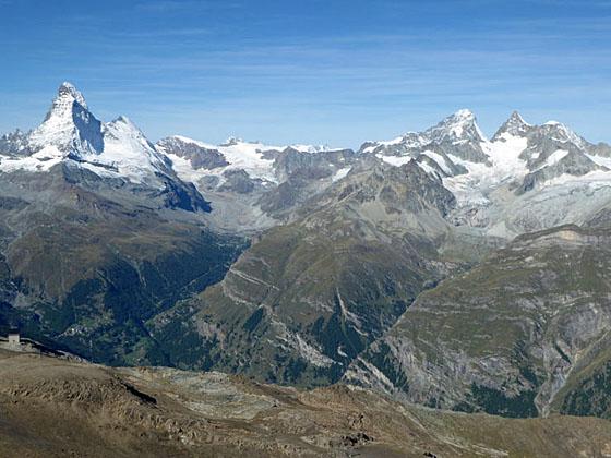
At the top of the Unterrothorn enjoy wonderful views of the Matterhorn to the southwest. Across the Zermatt valley a massive wall of 4,000-meter peaks, including the Ober Gabelhorn massif, the Wellenkuppe, the Zinalrothorn and the Weisshorn, fill the skyline. To the south, Monte Rosa and Lyskamm form the backdrop for the long ridge running between Gornergrat and Hohtalli. Signboards near the lift station help you identify the peaks.
From the signpost near the cable car station, descend east on a broad rutted path in the direction of Furggli, Fluhalp and the Oberrothorn. Reach a junction on the saddle on the ridge between the Unterrothorn and the Oberrothorn at 0.5 miles after losing 400-ft. Here a sign points left (north) to Tufterchumme (Tufternkumme). We continue straight ahead toward the Oberrothorn, reaching a junction at Furggli (9,970-ft.) at 0.6 miles. Here a broad track branches right to Blauherd, Stellisee and Sunnegga. We head east toward the Oberrothorn.
Skip down to the section entitled, “Hiking to the Summit,” to continue the description
From Blauherd to the Oberrothorn
- Distance from Trailhead: 5.4 miles (round-trip)
9.1 miles (point-to-point) Blauherd - Oberrothorn - Sunnegga - Elevation: 8,453-ft. at Blauherd
- Elevation at the Oberrothorn: 11,190-ft.
- Elevation Gain: 2,755-ft.
Start the day by riding the funicular to Sunnegga, a popular overlook with panoramic views of the Matterhorn, and then catch the gondola to Blauherd (8,435-ft.). You can purchase a ticket from Zermatt to Blauherd and a return ticket from Sunnegga to Zermatt. Other options are available. (See the trailhead directions below.)
At the top of the Blauherd lift enjoy wonderful views of the Matterhorn to the southwest. Across the Zermatt valley a massive wall of 4,000-meter peaks, including the Ober Gabelhorn massif, the Wellenkuppe, the Zinalrothorn and the Weisshorn, fill the skyline. To the south, the Monte Rosa massif and Lyskamm form the backdrop for the long ridge running between Gornergrat and Hohtalli.
From the signpost near the gondola station, walk east on a broad track ascending toward the Unterrothorn (1-hr 40-min) and Oberrothorn (3-hr 10-min). The trail curves around the base of the Unterrothorn, reaching a junction at 0.8 miles. Along the way the path enjoys great views of the Matterhorn and Monte Rosa-Breithorn group.
At the junction, turn left (north) on a dirt road climbing steeply toward the Unterrothorn and Oberrothorn. As you climb, watch for a trail branching left (north) off the road at 1.0 mile. Take the trail, which ascends through meadows paralleling the road. (It is best to leave the road since it is used by mountain bikers that fly down the hill from the Rothorn lift.)
Reach a junction at Furggli (9,970-ft.), a saddle on the ridge between the Unterrothorn and the Oberrothorn, at 1.4 miles. Turn right (east) toward the Oberrothorn. Ignore the trail to the left that climbs to the Rothorn cable car station on the summit of the Unterrothorn.
Hiking to the Oberrothorn Summit
(The description below includes two mileage numbers for each point along the trail. The first is the distance from the Rothorn lift and the second is the distance from the Blauherd lift.)
From Furggli, the trail heads east, ascending the south face of the Oberrothorn on moderate grades. At 0.8 miles/1.6 miles the grade steepens as the path turns left (northeast) and starts climbing a series of switchbacks up rocky slopes littered with shale.
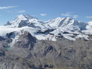
As you climb, enjoy marvelous views south to the glaciated chain of 13,000-ft. (4,000-meter) peaks forming the border between Switzerland and Italy, including Monte Rosa, Lyskamm, Castor, Pollux and the Breithorn. Bookending the western end of the visible chain is the distinctive pyramid-shaped Matterhorn. To the southeast the Findel Glacier flows down the slopes of the Cima di Jazzi (12,477-ft.) between the Strahlhorn and Rimpfishhorn, to the north, and the Stockhorn, to the south.
At 1.2 miles/2.0 miles fix ropes offer a level of security where a section of exposed trail climbs very steeply around a rock outcropping. The trail should not present any problems to experienced hikers unless it is covered with snow and/or ice.
Reach a ridge extending southeast at 1.4 miles/2.2 miles. Take a short detour to an overlook at the edge of the ridge for terrific views of the Mischabel Range, including the Strahlhorn, Rimpfischhorn and the Allalinhorn. The trail now turns northwest, climbing up the ridge on steep switchbacks.
Attain the south ridge of the Oberrothorn at 1.7 miles/2.5 miles. Follow the trail as it heads north on an ascending traverse along the west side of the ridge, reaching the top of the Oberrothorn (11,200-ft.) at 1.9 miles/2.8 miles. Use caution if snow is present atop the peak.
From the summit, marvelous panoramic views extend in all directions. Across the valley to the west Dent Blanche, the Ober Gabelhorn massif, the Zinalrothorn and the Weisshorn tower above the Zermatt Valley. Looking north, the Dom, Taschhorn and Alphubel dominate the view. To the east, glaciers cling to the flanks of the Rimpfischhorn, Strahlhorn and Adlerhorn. An incredible spectacle of peaks and glaciers along the Swiss-Italian border, including Monte Rosa, Lyskamm and the Breithorn, fill the skyline to the south while the majestic Matterhorn stands alone at the head of the valley.
Oberrothorn to Sunnegga
Distance from Trailhead: 9.1 miles (round trip)
Ending/Highest Elevation: 7,217-ft.
Elevation Gain: -3,973-ft.
When you are done enjoying the views head back down the trail. At 3.2 miles/4.0 miles (1.3 miles from the summit), reach a signpost at Furggli. Here you have a choice of heading to the Rothorn cable car (a 3.8 mile/4.6 mile hike) and taking the lifts back to Sunnegga, walking down to Blauherd or walking all the way back to Sunnegga. If it is a nice day, I recommend walking to Sunnegga.
To walk to Sunnegga, turn left (south/southwest) at the signpost in the direction of Fluealp, Blauherd and Sunnegga. Descend steeply down a dirt road for a short distance, watching for a trail breaking off to the right. Take the trail, which parallels the road, descending through meadows. (It is best to leave the road since it is used by mountain bikers that fly down the hill from the Rothorn lift.)
Reach at junction at 3.8 miles/4.6 miles. The trail branching right (west) to Blauherd (25-min) and Sunnegga (1h 10min) is the fastest route. This path curves around the base of the Unterrothorn, reaching Blauherd in 0.9 miles. Along the way enjoy great views of the Matterhorn and Monte Rosa-Breithorn group.
The trail to the left (south/southwest), signed for the Stellisee (50min), Sunnegga (1-hr 55-min) and Fluealp, is longer but offers the opportunity to visit the Stellisee, a small lake famous with photographers for its wonderful views of the Matterhorn perfectly reflected on the lake’s crystalline waters.
If you are not in a hurry and are enjoying the hike, turn left toward the Stellisee. Travel along the ski area service road for 0.2 miles and then take the trail branching right, which zig-zags down rocky meadows to rejoin the road at 4.3 miles/5.1 miles.
Upon reaching the road ignore the trail directly across the way pointing toward Flue and Fluealp. Instead turn right (south) onto the broad track heading toward the Stellisee and Sunnegga. As you descend the Berghaus Flue at Fluehalp is visible to the southeast.
At 4.4 miles/5.2 miles watch for an unmarked trail (a short-cut) that heads right (east) through meadows and an old rock slide toward the Stellisee. Take this trail. If you miss the turn you will reach a road where you should turn right (east) toward the lake.
Arrive at the east end of the Stellisee at 4.8 miles/5.6 miles. Views of the Matterhorn from the mirror-like surface of the lake are sublime. The lake is a great spot for a picnic and to soak in the sun while gazing at the Matterhorn.
When you are ready to move on, walk along the north side of the lake to a signpost at the west end of the lake at 5.0 miles/5.8 miles. Here you have several options. The shortest is to walk to Blauherd and take the gondola back to Sunnegga. From Blauherd there three options for walking back Sunnegga. Looking at the map you will see other options that take you past the Leisee, a popular tarn.
At the west end of the Stellisee turn right (northwest) toward Blauherd. The path climbs on gentle grades to the top station for the Blauherd gondola (8,435-ft.), at 5.7 miles/6.5 miles. The walk features nice views of the Matterhorn and the Findel Glacier area (behind you to the east).
At Blauherd either take the gondola to Sunnegga or hike down to Sunnegga. If you decide to hike there are three options. Along the south side of the gondola/lift station, a trail drops steeply down the hillside and then descends through meadows to the south of the gondola, arriving in Sunnegga after 1.4 miles for a total hiking distance of 7.1 miles/7.9 miles. A road, which departs from the north side of the gondola/lift station, parallels the route of the gondola slightly to the north of the lift line, dropping on steep grades to Sunnegga in 1.2 miles for a 6.9 mile/7.7 mile hike.
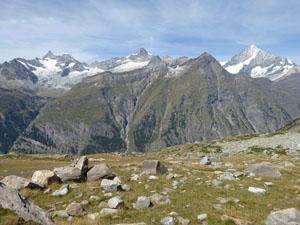
For hikers looking for a longer, more scenic and less traveled route, I recommend taking a side trip to Tufteren and then head back to Sunnegga. From the signpost near the lift station, walk northwest on a broad track toward Tufteren and Zermatt. Shortly after passing under a chair lift the track reverts to a trail that descends through beautiful wildflower-filled meadows strewn with large boulders. The Weisshorn, Zinalrothorn and Ober Gabelhorn group along with the Matterhorn dominate the views along this scenic trail.
At 7.1 miles/7.9 miles arrive at a junction. The trail heading right previously lead to Ober Sattla, a lovely viewpoint above Tasch, that is now closed due to a landslide. We turn left (southwest) toward Tufteren and Sunnegga.
Reach Tufteren (7,267-ft.), a small village of wooden houses and barns set amid lovely meadow high above the Zermatt Valley, at 7.3 miles/8.1 miles. A few restaurants serve refreshments from sun terraces with great views of the Matterhorn. Here signs point left to the track heading south toward Sunnegga.
The rest of the walk is mostly level, following a broad, dirt track lined with larches growing amid pretty meadows. Openings in the trees offer nice views of the Matterhorn. As you near Sunnegga you may run into some mountain bikes.
Bear left at a junction at 8.2 miles toward Sunnegga. In a short distance you will see doorways that lead to the funicular station. Total hiking distance, including the side trip to Tufteren, is 8.3 miles/9.1 miles.
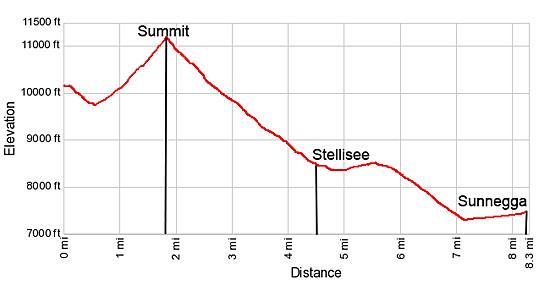
Elevation Profile
Driving Directions
Walking from the Zermatt Train Station to the Sunnegga Funicular: Directly across from the Zermatt train station is the station for the Gornergrat Cog Railway. The first street to the south of the Gornergrat Station is Getwingstrasse (Getwing Street), which runs east. Find Getwingstrasse and walk east along the street for 0.2 miles (300-meters). The street will curve to the southeast and cross the Vispa River.
On the other side of the river turn left (east/northeast) on Vispastrasse (also labeled as Rechte Uferstrasse on some maps). Walk about 0.1 miles, following the street as it curves to the north/northeast. The Sunnegga Funicular Station is on the right side of the road at Vispastrasse 34.
After obtaining funicular tickets, walk through a long underground tunnel to get to the base of the funicular. The schedule for the funicular is found on the Matterhorn Paradise time table page. Select the Sunnegga – Rothorn option.
Note: At the top of the funicular take the gondola to Blauherd. (Exit the funicular building and follow the signs to the Blauherd gondola.) At Blauherd you catch the cable car to Rothorn. Round-trip tickets are available for a variety of ride combinations. For example you can purchase tickets from Zermatt to Rothorn going up and from Sunnegga to Zermatt going down.
Trail Resources
Trail Intro / Trail Photo Gallery / Trail Map
Basecamp(s) Information:
Zermatt
Region Information:
The Valais
Other Hiking Regions in:
Switzerland