Hike Facts
- Distance: 13.7 miles (round trip)
- Elevation: 8,490-ft. - 8,916-ft.
- Elevation Gain: 0-ft. - 1,800-ft.
- Difficulty: strenuous
- Trail Highlights: See Trail Intro
- Basecamp(s): Zermatt
- Region: The Valais
Two great trails with terrific views of the Matterhorn are combined to create a fantastic hike to Schonbiel Hut, sitting atop a scenic overlook at the head of the Zmutt Valley.
Trailhead to Stafelalp
Distance from Trailhead: 2.0 miles (one way)
Ending/Highest Elevation: 8,490-ft.
Elevation Gain: -1,276-ft.
Note: This description of the Schonbielhutte (Schonbiel Hut) trail starts on the Matterhorn Plateau at Schwarzsee, reached by taking the Matterhorn Paradise / Schwarzsee Gondola. If you choose to walk from Zermatt to Schwarzsee add four to five miles (depending on the route) and 3,100-ft. in elevation gain to the hike. (See the directions to the trailhead for more information.)
Most people walk to Schonbielhutte via a 14.6 mile out-and-back trail that passes through Zmutt and Chalbermatten. My recommended route to the hut starts at Schwarzsee and combines two great trails, the Matterhorn and Schonbielhutte trails, for a fantastic point-to-point hike with stunning views of the Matterhorn, Dent Blanche and the Ober Gabelhorn massif.
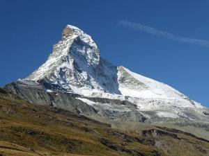
Schwarzsee (8,490-ft.), a popular viewpoint, is located on the Matterhorn plateau beneath the Matterhorn’s northeast ridge known as the Hornligrat – considered to be the easiest route to the summit. From the viewpoint visitors are treated to expansive views of the Matterhorn’s east and north faces. Hornlihutte, the basecamp for climbers tackling the Hornligrat, is clearly visible at the base of the ridge.
The viewpoint also enjoys panoramic views of Monte Rosa (15,203-ft.), Lyskamm (14,852-ft.) and the Breithorn (13,665-ft.) to the southeast. The Mischabel Range, with its two highest peaks -- the Dom (14,911-ft.) and Taschhorn (14,733-ft.), along with the Findel Glacier dominate the view the northeast while Dent Blanche (14,291-ft.) and the Ober Gabelhorn (13,330-ft.) massif fill the skyline to the northwest.
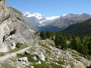
When you are done taking in the views find the signpost near the Hotel Schwarzsee (accommodations and restaurant) where markers point to broad track descending northwest across the plateau toward Stafelalp (25-min), Schonbielhutte (3-hr 20-min) and the Matterhorn Trail. Follow the track as it drops through meadows sprinkled with wildflowers, passing a pretty little chapel near a tarn. Herds of blacknose sheep are often seen grazing in the meadows.
After walking 0.75 miles stunning views open to the Matterhorn’s sheer north face and the Matterhorn glacier. This view, from different perspectives, will be your constant companion for much of the hike. Across the valley the Ober Gabelhorn massif and Dent Blanche dominate the view. As you continue descending views of the peaks and glaciers at the head of the Zmutt Valley join the scene.
The meadows soon give way to a scattered forest of larch and pine trees as the trail passes a small pond at 1.5 miles. Beyond the pond the grade steepens. Clearings now offer views of the settling ponds and buildings on the valley floor that form part of the Grande Dixence hydroelectric system. The trail soon crosses a stream and then descends to the Stefelalp Restaurant (7,214-ft.) at 2.0 miles.
Stafealp to Schonbiel Hut
Distance from Trailhead: 6.4 miles (one way)
Ending/Highest Elevation: 8,916-ft.
Elevation Gain: 1,800-ft.
Near the restaurant signs points left (west) toward Arbenbach and Schonbielhütte and right (east) to Zmutt and Zermatt. Turn left and descend along a broad track to a junction with a dirt road at 2.2 miles. Turn left onto the dirt road in the direction of Arbenbach and Schonbielhutte. The Matterhorn’s north face now towers overhead. Several waterfalls, fed by glacial melt, tumble down crevasses in the cliff face below the Matterhorn Glacier. Straight ahead to the west are nice views of the peaks and glaciers at the head of the valley.
At 2.5 miles reach a junction and turn right on the road that heads toward the hydroelectric project. The turn is marked with two small yellow signs. Our path now leads through an unattractive area housing hydroelectric buildings and equipment along with settling ponds amid the gravelly remains of the receding Zmutt Glacier. Signs near the buildings describe the immense Grande Dixence hydroelectric project.
The area around the hydro project is an unfortunately an eyesore. Divert your attention from the man-made structures by turning around for more great views of the Matterhorn. To the east the Oberrothorn, Rimpfishhorn, Strahlhorn and Adlerhorn rise above the Findel Glacier. Across the valley a pretty waterfall tumbles down a rock outcropping. The trail to Schonbielhutte climbs switchbacks up the right side of the falls.
A short distance beyond the hydroelectric building cross a bridge and follow the road as it skirts the right (east) side of a large settling pond. Just beyond the settling pond turn right (east) on a road, which may be unmarked. This trail will cross a bridge and reach a signed junction with the Schnobielhutte trail at 3.0 miles. Turn left in the direction of Schonbielhutte and Arbenbach.
The trail now travels beside a rock face and then climbs moderately steep switchbacks up the right (east) side of a gully across from a photogenic waterfall. At the top of the switchbacks the path crosses the gully and then climbs to a bench beside the north lateral moraine of the Zmutt Glacier. Follow the trail as it heads west ascending through meadows on easy grades, paralleling the stream and moraine wall to your left.
Reach the junction with the Hohbalm Trail branching to the right (north) at 3.8 miles. Continue straight ahead toward Schonbielhutte. Be sure to turn around at this point for nice views of Monte Rosa and Lyskamm rising beyond the Matterhorn plateau.
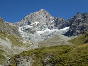
Soon the trail crosses a bridge over a stream at the mouth of the Arben Valley. The Ober Gabelhorn towers above the head of the valley. Just beyond the bridge reach a junction for the route to Platten splitting off to the right (north). We proceed straight ahead in the direction of the Schonbielhutte (1-hr 20-min).
The moderate ascent up the valley is delightful, traveling through rocky meadows sprinkled with wildflowers. Views soon open to waterfalls cascading off the rock face below the Hohmang Glacier, spilling down the north side of the valley between the Ponte de Zinal and Mont Durand. The Matterhorn’s north face looms above the valley to the south while straight ahead the cirque of mountains adorned with glaciers at the head of the Zmutt valley become more impressive with each step.
Reach a junction at 5.0 where an old trail, blocked by rocks, climbs along the top of the glacial moraine. (This trail is no longer safe due to extensive eroding of the moraine wall.) Bear right on the new trail, marked with a rusty metal sign, which travels beside a small pond and then climbs moderately steep grades up the trough between the moraine wall and the sheer south face of the Gemssptiz.
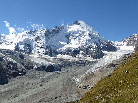
For a brief period the moraine wall blocks views to the south. Soon the trail climbs out of the trough and moves to the top of the moraine wall, which is now wider and safe for travel. Views open to the Zmutt Glacier’s massive river of ice, masked with rock debris and pitted with crevasses, covering the valley floor. Dent d’ Herens, Tete de Valpelline and Tete Blanche, draped with glaciers, ring the head of the valley. Schonbiel Hut is now clearly visible on the hill above the trail.
At 5.7 miles the trail swings off the moraine wall and starts a steep ascent up a long series of switchbacks to Schonbielhutte. (Note: You may see two trails at the bottom of the switchbacks. The correct trail is the one branching to the right. Red arrows on the rocks will keep you on track.) Take a rest as you climb to enjoy the views.
Reach Schonbielhutte (8,840-ft.) at 6.2 miles after gaining 500-ft. The hut, providing dormitory accommodations and refreshments, sits atop a small grassy plateau overlooking the Zmutt Glacier. From the hut's sun terrace enjoy stunning 270-degree views that encompass the Findel Glacier, the Monte Rosa massif, the Matterhorn's north and west faces and Dent d'Herens. At the head of the valley the Tiefmatten, Stockji and Schonbiel glaciers combine with the Zmutt Glacier to form the massive river of ice, covered in huge boulder and rock debris, flowing along the valley floor.
After enjoying the views from the hut, travel around the front of the hut and follow a use trail that leads west to the end of the plateau (an additional 0.2 miles). Here a marvelous overlook offers front row seats to the glaciers tumbling down the valleys between Dent d’Herens, Tete de Valpelline, Tete Blanche, Wandfluehorn, Dent Blanche and Pte de Zinal. Directly in front of you a glacier hangs from cliff face. Occasionally chunks of the glacier breakoff and crash to the valley floor.
Schonbiel Hut to Zermatt
Distance from Trailhead: 13.7 miles (round trip)
Ending/Highest Elevation: 5,325-ft.
Elevation Gain: -3,591-ft.
When you are done taking in the views, return to Zermatt by reversing the route to the point directly below the waterfall, about 3.0 miles from the viewpoint and 9.4 miles from the start. Do not cross the valley near the hydro facility but instead continue along the north side of the valley following signs toward Zmutt.
At the bottom of the falls the trail briefly travels beside cliffs along the valley’s north wall before arriving at a trail detour. (The original trail was wiped out by a rockfall and the area is still unstable.) Turn right (southeast) at the detour and follow the rerouted trail as it descends through larch trees, passing a sign for a route to Zermatt and Furi branching off to the right. Ignore this trail and continue straight ahead in the direction of Chalbermatten, Zmutt and Zermatt.
At 9.8 miles reach a bridge crossing the Zmuttbach (Zmutt River). Do not cross the bridge but instead go left (east/northeast), following the trail as it drops around the bottom of the landslide and then climbs up steep, dusty switchbacks to the continuation of the main trail at 10.3 miles.
A good path now descends steadily east through meadows to Chalbermatten (6,906-ft.), the site of an old restaurant, at 10.8 miles. The Findel Glacier, Riffelalp and Gornergrat dominate the view to the east.
Beyond Chalbermatte the trail continues it moderate descending traverse, passing above the Zmutt reservoir and then traveling through pastures to Zmutt at 12.0 miles. The small village is a popular lunch spot and a favorite destination for tourist seeking a short walk from Zermatt.
The rest of the hike is on a popular trail that descends along a wide, pleasant track, passing some old buildings and grain storehouses. At 12.4 miles the trail drops steeply down a few switchbacks and then curves left (northeast) as it heads back to Zermatt..
Reach the south end of Zermatt at 13.7 miles. From here you can either hop on an electric shuttle bus (fee required) or walk 0.8 miles back through town to the start of the hike for a total distance of 14.5 miles. (When in doubt, follow signs pointing to the Zermatt Bahnhoff.)
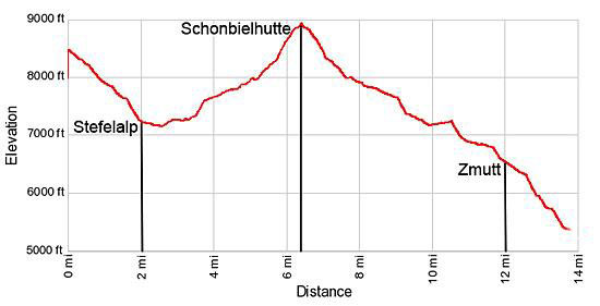
Elevation Profile
Driving Directions
Walking Directions From the Zermatt Bahnhoff (Train Station) to the Schwarzee Lift Station: Walk south/southwest on Bahnhoffstrasse, the town’s main street, for 0.3 miles and then turn left onto Kirchstrasse (Church Street). You will pass the Matterhorn Museum on the left just before the turn. (The Pfarrkirche St. Mauritius (church) is located on the southeast corner of Bahnhoffstrasse and Kirchstrasse.)
Walk down Kirchstrasse for 0.1 miles, crossing the bridge over the river, and then turn right on Schluhmattstrasse (Schluhmatt Street), the first street past the river. Follow Schluhmattstrasse for 0.4 miles to the Matterhorn Glacier Paradise / Schwarzsee Gondola Station. Purchase a one-way ticket to Schwarzsee.
Hiking to Schwarzee: Walking from the lift station to Schwarzsee adds 4 to 5 miles (depending on the route) and over 3,100-ft. in elevation gain to the hike. To walk from the bottom of the Schwarzsee lift station, follow the yellow trail signs for Blatten, Zum See, Furi and Schwarzsee. The trail ascends through trees and meadows to the Schwarzee on the Matterhorn plateau. The section of the trail from Zermatt to Furi walks under or near the gondola. Beyond Furi, a mid-station for the gondola, the route enjoys some nice views of the Gorner Glacier Garden area.
Trail Resources
Trail Intro / Trail Photo Gallery / Trail Map
Basecamp(s) Information:
Zermatt
Region Information:
The Valais
Other Hiking Regions in:
Switzerland