Hike Facts
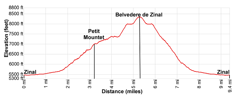
- Distance: 9.4 miles (round trip)
- Elevation: 5,450-ft. - 8,345-ft.
- Elevation Gain: 2,971-ft.
- Difficulty: strenuous
- Trail Highlights: See Trail Intro
- Basecamp(s): Zinal
- Region: The Valais
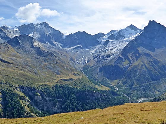
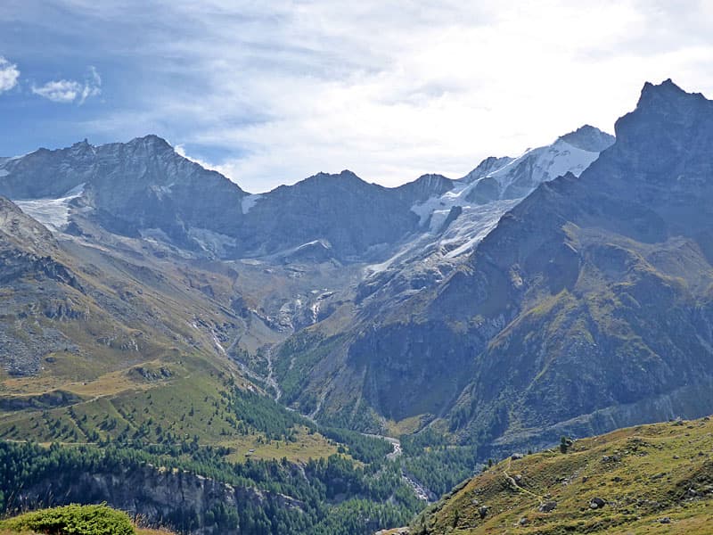
A stiff climb to a high belvedere features dramatic, nonstop views of the summits rising above the east side and the head of the Zinal Valley. Along the way the path visits the Petit Mountet hut and travels through beautiful meadows with see-forever views.
Belvedere Zinal
From the center of Zinal walk toward the head of the valley (south) on the main street. Reach a car park at 0.6 miles (1.0 km) and turn right (west), crossing a wood bridge over the La Navisence River, the river draining the Zinal Valley. On the west side of the river turn left (south) and continue walking up the Zinal Valley in the direction of the Petit Mountet (1h 50min) and Grand Mountet (4h 10min). The broad track ascends through pastures on easy grades with nice views of Besso towering above the east side of the valley.
Pass a junction at 1.7 miles (2.7-km) with a route branching left toward Lac Arpitettaz and the Arpitettaz Hut. Our track continues south and soon starts ascending on moderately-steep grades through meadows and scattered trees.
At 2.2 miles (3.5 km) the trail travels by a pretty waterfall, climbs a switchback and soon reaches a junction at Le Vichiesso (6,109-ft.). Here we turn right on a trail toward the Petit Mountet (45min). This is a shorter, steeper trail to the hut. The trail continuing along the main track toward the Petit Mountet (1h), Grand Mountet (3h 20min) and the Arpitettaz Hut is not as steep but will add 0.75 miles (1.2-km) to the hike.
The narrow path to the Petit Mountet ascends on steep grades through meadows and trees. Chain affixed to rocks secure climbs up rocky sections of the path. Along the way the trail crosses two streams on wood bridges. Openings offer views of Besso rising to the southeast. Soon the Pointe de Zinal and the Grand Cornier, towering above the head of the valley, join the scene. The Weisshorn soars about the shallow tributary valley to the east.
At 3.1 miles (5.0 km) the trail reaches a junction where it rejoins the main track coming up the valley. The final section of the climb is very steep, reaching the Petit Mountet at 3.2 miles (5.1 km). The hut is set atop the lateral moraine along the east side of the upper Zinal Valley. Here you can stop for some refreshments and enjoy the views before continuing the hike.
A short distance past the hut is a trail junction. Here we turn right toward Alpage de la Lee (45 min) and the route to Sorebois (3h 10). The path now descends switchbacks down the backside of the moraine and then turns right (northwest) as it ascends on moderate grades through pretty meadows. Along the way pass a route branching left toward the Moiry and Grand Mountet huts.
As you climb enjoy ever improving views of the Weisshorn and the Schalihorn rising to the northeast. Behind you are fine views of the Pointe de Zinal and Mont Durand. At 3.8 miles (6.1 km) the themed Tour des Myrtille (Blueberry trail) branches right. We continue straight ahead.
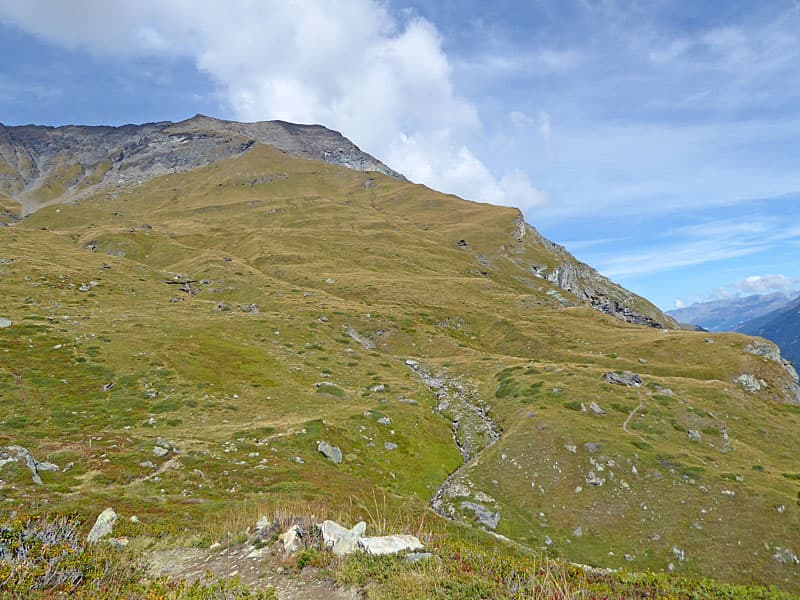
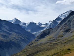
Above the trail a ridge of 9,800-ft. (3000-meter) peaks, the Aiquilles de la Le, rim the valley to the west. Ahead views open to Peak 3274 rising above a grassy ridge. Our destination is at the lower end of the ridge.
Pass a second route branching left toward the Moriy Hut at 4.1 miles (6.6-km). Our trail soon dips into a shallow drainage, crosses two streams and then reaches a junction at 4.3 miles (6.9-km). To the right is a trail dropping down to Vichiesso and Zinal, which we will use on the return leg of the hike. We turn left (west) on the route (signified by a blue sign) toward Sorebois.
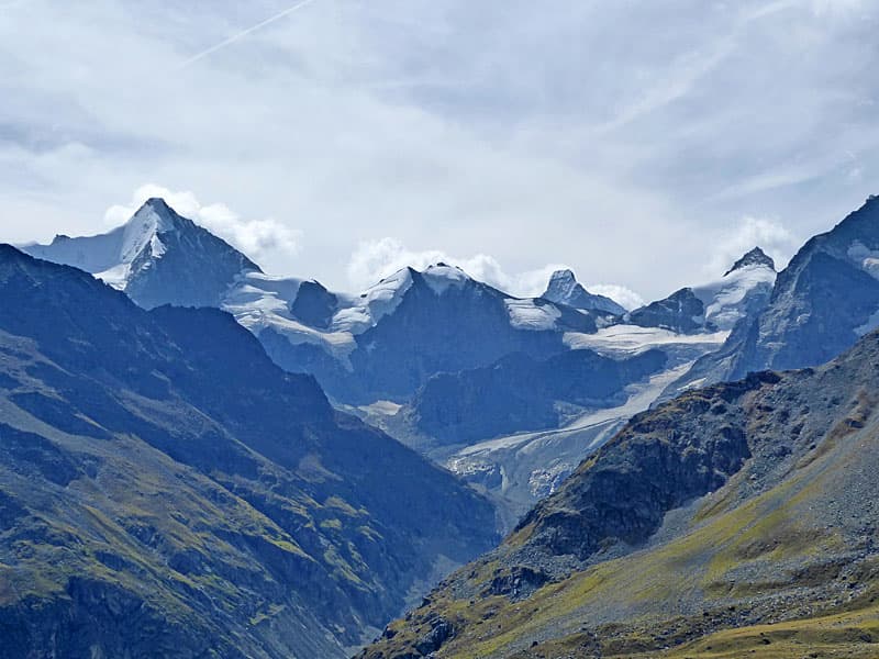
The path climbs on very steep grades up a grassy slope, staying to the north side of a stream. Turn around for fantastic views of the Weisshorn, Schalihorn and Zinalrothorn rimming the shallow tributary valley to the east. Besso and the Pointe d'Ar Pitetta guard the entrance to the tributary valley. To the southeast at the head of the valley, the Ober Gabelhorn towers above Mont Durand. Soon the summit of the Matterhorn is seen rising beyond Mont Durand.
At 4.7 miles (7.6 km) the trail passes a small building set behind a boulder. A short distance beyond the grades abates as the path curves to the right (north). This is a good spot to catch your breath and enjoy the views.
The trail now traverses along the grassy slopes. Soon you will pass a sign, leaning against a rock, pointing back to the Cabane Petit Mountet along with blue and white strips painted on the rock, signifying that you are on a route and not a trail. Above the trail are great views of the Aiquilles de la Le ridge. The Pigne de la Le anchors the ridge to the south.
As you continue along the trail enjoy ever improving views of the peaks rimming the head of the Zinal Valley. Dent Blanche and the Grand Cornier soon join the scene. On a clear day the Matterhorn is now clearly seen rising in the gap between the Pointe de Zinal and Mont Durand. Les Diablons rises to the northwest.
At 5.0 miles (8.0 km) the trail starts the final, very steep climb toward the overlook. Progress will be slow on this stretch as you will pause often to take in the amazing views of the peaks rising to the east side and the summits forming the cirque at the head of the valley.
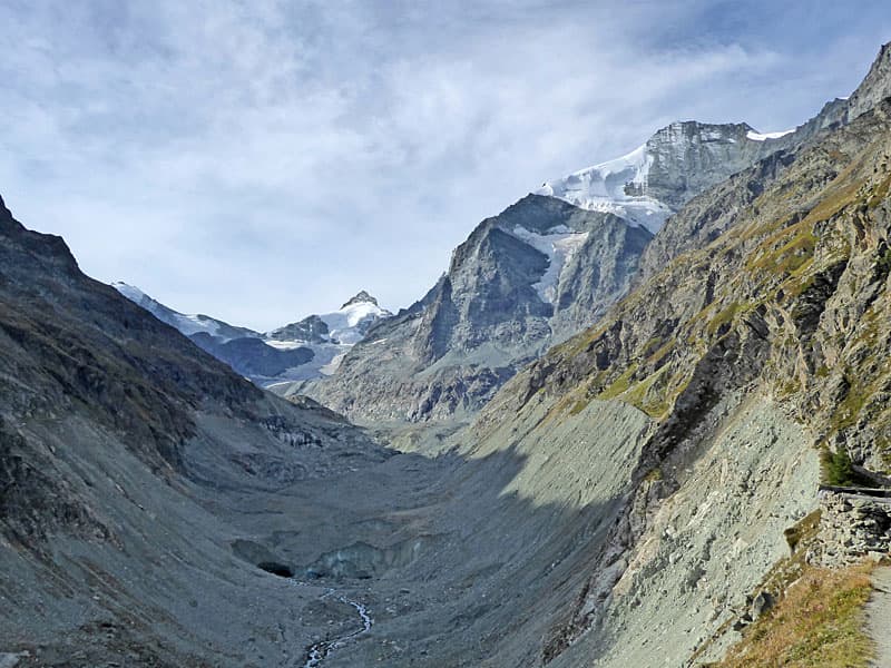
Soon the grade abates as the trail curves around a shoulder on a ridge and arrives at the overlook at 5.3 miles (8.5 km). At the overlook a rock outcropping is marked with blue and white route marker. Here views open to a large rock slide along the east facing slopes of Peak 3274. Zinal is seen along the valley floor. View stretch down the valley to the summits rising above the Rhone Valley to the north.
This is the turnaround point for the hike. Beyond the overlook the route climbs down a rocky ledge before traveling along increasingly steep slopes to the edge of a broad rock slide in 0.3 miles (0.5 km). The slide is still active. The narrow, exposed route through the debris is constantly changing. Do no expect stable footing. Beyond this slide the route passes through scree-covered slopes and additional avalanche chutes/rock slide.
These slides are responsible for the large debris fields covering sections of the pastures to the south of Zinal. Over the years the debris fields in the valley are expanding and will continue to do so.
Turn around after taking in the views and find a resting place for a snack or picnic. I personally prefer curving back around the ridge and then finding a spot to sit and enjoy the incredible views.
After taking in the views retrace your steps down the grassy slopes, enjoying the views all over again. At 6.25 miles (10.1 km) reach the junction with the trails to Vichiesso and the Petit Mountet. I recommend turning left and taking the trail to Vichiesso, which is steeper but shorter. Alternative you can turn right and retrace your steps back to the Petit Mountet and then Zinal for a 10.6 mile (17 km) hike.
The trail to Vichiesso descends on steep grades through meadows, bushes and scattered trees, crossing two streams along the way. Openings offer fine views of the Weisshorn, Shalihorn and Besso and a waterfall along the Torrent de l’Arpitetta, the tributary stream draining into La Navisence. At 7.1 miles (11.4 km) the trail reaches the junction with the path we originally used to climb to the Petit Moutet. Turn left here toward Zinal.
At 7.2 miles (11.6 km) reach the junction at Le Vichiesso. Here we turn left on the main track to Zinal. Retrace your steps back to the village for a 9.4 mile (15.1 km) hike.
Route from Sorbois to the Petit Mountet
This trail is only recommended for experienced, sure-footed hiker comfortable on exposed routes with poor footing. A long section of the hike is along a narrow, exposed route traveling through avalanche/landslides with unstable/shifting rocks. Before attempting this route it is imperative that you check on current conditions at the Zinal Tourist Office.
Start the day by riding the cable car to Sorebois. Find the trail signpost behind the lift station and then walk south on a broad track toward the Petite Mountet. Note this is a blue sign meaning that it is a route and not a trail.
At 0.3 miles (0.5 km) pass a junction with a trail branching left and dropping down to Zinal. At 0.5 miles (0.8 km) bear left on a narrow route marked by arrows on a rock. Across the valley are grand views of Les Diablons and the cirque formed by the Weisshorn, Schalihorn, Zinalrothorn and Le Besso. The Moming Glacier spills down the slopes of the Zinalrothorn and Schalihorn. These views will improve and evolve as you continue along the route.
The route ascends through rocky meadows, crossing a stream carrying meltwater from snowfields above the trail at 1.5 miles. At 2.0 miles the trail crosses a gully where chains attached to the rock face provide a level of security.
Over the next 0.5 miles the route passes beneath the steep, east facing slopes of the Garda Bordon and Peak 3274. The narrow, undulating route, with exposed sections, ascends through scree covered slopes along with avalanche/rockslide areas with unstable and shifting rocks. The conditions change every year and even during the hiking season after rain/snow events. ALWAYS check with the Zinal Tourism Office to determine the current condition of the trail. At times this route is closed for unsafe conditions.
Near the end of the final rockslide, beneath the slopes of Peak 3274, we reach the high point of the hike. The path now descends along a section of the route with some exposure before a short ascent up a ledge leads to a broad, grassy bench along a ridge at 2.9 miles (4.7 km). The author calls this spot the Belvedere de Zinal.
The path now curves around the ridge. Here the terrain opens to broad meadows beneath the Aiquilles de la Le ridge. Stunning views expand to include the peaks towering above the head of the Zinal Valley including the Ober Gabelhorn, Mont Durand, Point de Zinal, Dent Blanche and the Grand Cornier. On a clear day you can see the summit of the Matterhorn rising between Mont Durand and the Point de Zinal.
The route now descends on very steep grades accompanies by terrific views of the peaks rimming the east side of the valley and the summits ringing the head of the valley. At 3.2 miles (5.1 km) the grade briefly abates as the narrow trails travels through pastures. The respite is short lived. At 3.5 miles (5.6 km) the path curves to the left and again descends on steep grades. At 3.8 miles (6.1 km) reach the junction with trails to Vichiesso and the Petit Mountet. I recommend turning left and taking the trail to Vichiesso, which is steeper but shorter, resulting in a 7.0 miles (11.3 km) hike. Alternative you can turn right toward the Petit Mountet and then descend to Zinal for an 8.2-mile (13.2km) hike.
See the description of the Belvedere Zinal hike for more detail on the two trails back to Zinal.
Elevation Profile
Driving Directions
Directions in Zinal: This hike starts from the Zinal Centre Bus stop, located in front of the Swisspeak Resort Office in Zinal. Walk south along Rue des Cinque 4000 (the town’s main street), following the signs to the Petit Mountet.
From Grimentz to Zinal: From one of several bus stops in Grimentz, board the bus to Zinal and get off at the Zinal Centre stop, located in front of the Swisspeak Resort office. If possible, catch a direct bus to Zinal. Otherwise, take the Vissoie Bus to Vissoie where you will need to change for a bus heading up the valley to Zinal. The direct buses take 15 minutes. If you need to change in Vissoie the ride will take 50 minutes or slightly longer, depending on the time of day.
Buses make several stops in Grimentz. Schedules are posted at the bus stops. Departure times are also available online at the SBB website and the SBB app.
Directions to the Sorbois lift for the Route:
From Zinal to the Sorebois Cable Car: From the Zinal Centre Bus Stop, in front of the Swisspeak Resort office, walk north along the main street for a short distance to the Zinal Telepherique (Cable Car station) and take the cable car to Sorebois.
From Grimentz to the Sorebois Cable Car: From Grimentz, board the bus to Zinal and get off at the Zinal Telepherique (Gondola) station and take the gondola to Sorebois (do not take the lift all the way to La Vouarda). If possible, catch a direct bus to Zinal. Otherwise, take the Vissoie Bus to Vissoie where you will need to change for a bus headed up valley to Zinal. The direct buses take 15 minutes. If you need to change in Vissoie the ride will take 50 minutes.
Buses make several stops in Grimentz. Schedules are posted at the bus stops and are available online at the SBB website and the SBB app.
Trail Resources
Trail Intro / Trail Photo Gallery / Trail Map
Basecamp(s) Information:
Zinal
Region Information:
The Valais
Other Hiking Regions in:
Switzerland