Details: Cabane du Grand Mountet 
Distance: 12.2 - 14.1 miles (round trip)
near Zinal in The Valais
By: Diane Greer
Hike Facts
- Distance: 12.2 - 14.1 miles (round trip)
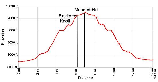
- Elevation: 5,480-ft. - 9,520-ft.
- Elevation Gain: 3,804-ft. - 4,040-ft.
- Difficulty: strenuous-difficult
- Trail Highlights: See Trail Intro
- Basecamp(s): Zinal
- Region: The Valais
Magnificent views of one of the most stunning glacial cirques in the Pennine Alps is the reward for hikers completing this long and very strenuous hike to the Cabane du Grand Mountet at the head of the Zinal Valley.
Rocky Knoll
Distance from Trailhead: 12.2 miles (round trip)
Ending/Highest Elevation: 9,284-ft.
Elevation Gain: 3,804-ft.
Walk south, up the valley, on Zinal’s (5,479-ft) main street along the left (east) side of La Navisence, the river draining the Zinal Valley. Reach a car park at 0.6 miles and turn right (west), crossing the wood bridge over the river. On the west side of the river turn left (south) and continue walking up the Zinal valley in the direction of the Petite Mountet (1-hr 50-min) and Grand Mountet (4-hr 10-min). The broad track travels through pastures on easy grades with nice views of Besso towering above the east side of the valley.
Pass a junction at 1.7 miles with a route branching left toward Lac Arpitetta and the Arpitetta Hut. Our track continues south and soon starts ascending on moderately-steep grades up a wooded hillside along the west side of the valley.
At 2.2 miles the trail travels by a pretty waterfall and then climbs a switchback. Soon the path reaches a junction at Le Vichiesso (6,109-ft.). Here a trail branches right toward the Petite Mountet (45-min). We continue on the main track toward Petite Mountet (1-hr), Grand Mountet (3-hr 20-min) and the Arpitetta Hut.
The grade eases at 2.5 miles as the trail ascends the hillside. La Navisence tumbles down the rocky riverbed below the trail. Reach a junction at 2.9 miles and turn left (east) on the trail toward the Grand Mountet. The trail to the right leads to the Petite Mountet Hut.
Our trail drops down to and crosses La Navisence on a bridge. On the east side of the river is a “Y” intersection. We turn right toward the Grand Mountet. The trail to the left heads to the Arpitetta Hut and Roc de la Vache.
Follow the trail as it travels southeast through thick willows and then ascends steep switchbacks up the east side of the valley. As you climb, scattered trees soon give way to shrubs and rocky meadows. At 3.4 miles the trail briefly climbs along the remains of an old moraine wall, with nice views of the Grand Cornier, before continuing its stiff climb up the hillside on steep to very steep switchbacks. As you gain height, enjoy nice views to the north of the Garde de Bordon rising above the west side of Zinal. Pique de la Le, the Bouquetins and the Grand Cornier fill the skyline to the southwest.
At 4.4 miles the grade abates briefly as the trail contours through rocky meadows beneath the west face of Besso. To the north views open to Point Arpitetta and Les Diablons rising above the east side of the Zinal Valley. Soon the trail resumes its steep ascent. To the south Dent Blanche and the Pointe de Zinal enter the scene.
At 5.25 the trail drops down to and crosses a man-made, partially covered bridge providing safe passage across an avalanche chute. The descent to the bridge is quite steep. Use caution if the trail or the bridge is wet.
Follow the trail as it climbs out of the chute and then travels on easy grades for a short distance. At 5.6 miles the path starts an extremely steep ascent, aided by switchbacks, up the rocky flanks of Besso’s northwest ridge. Fixed chains provide a level of security and handholds to facilitate the climb up rocky, exposed and very steep sections of the trail. This is an extremely tiring section of the path. Take your time.
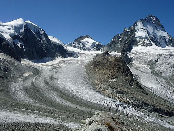
As you crest the ridge at 5.9 miles enjoy splendid views across the valley to the south/southwest of the Grand Cornier, Dent Blanche and the Pointe de Zinal. The Bouquetins, Grand Cornier and Durand glaciers spills down the flanks of the rugged peaks to join the Zinal Glacier, flowing along the valley floor. To the southeast views open to Mont Durand, the Ober Gabelhorn and the Wellenkuppe. These peaks along with the Zinalrothorn, still hidden from view, form the spectacular glacial cirque at the head of the valley.
Beyond the ridge crest the trail curves to the southeast as it climbs steeply through a boulder field. Red/white blazed rocks will keep you on track. The grade abates at 6.1 miles as the path ascends on easy to moderate grades to a rocky knoll (9,284-ft.). Along the way pass a wood sign indicating that the Cabane Grand Mountet is still 30 minutes away.
The knoll is a fabulous place to take a break and soak in the stunning views stretching from the ice-shrouded peaks of the Wellenkuppe and Ober Gabelhorn to the Grand Cornier. Glaciers, clinging to the flanks of the rugged peaks, glisten in the sun. Below you the Zinal Glacier, a massive river of ice flows down the valley. Besso rises above the trail to the northeast.
For many hikers the knoll is a good destination for a day hike. If you are tired or it’s getting late in the day or if the weather is taking a turn for the worse you should turn around at this point. The final mile to the hut crosses boulder fields and will take much longer than 30 minutes for hikers that are not adept at walking through piles of rock.
Cabane du Grand Mountet
Distance from Trailhead: 14.1 miles (round trip)
Ending/Highest Elevation: 9,520-ft.
Elevation Gain: 4,040-ft.
To continue to the hut, follow the trail as it ascends through the boulder fields on easy to moderate grades. Look ahead to find the next red/white markers to stay on route. In some areas that trail is clear, in other places you will need to take your time and scan for markers.
At 6.7 miles the trail skirts the southwest end of the Le Mammouth ridge, a massive granite fin protruding from the Dome that has been blocking views to the east. Beyond Le Mammouth, views open to the top of Zinalrothorn and the Trifthorn to the east/southeast. Directly across the valley are terrific views of Dent Blanche, towering above the valley, and the Durand and Grand Cornier glacier flowing around Roc Noir, a horn rising in front of the Pointe de Zinal.
The hike now gets easier. Reach the Cabane du Grand Mountet (9,459-ft.), with incredible views of the glacial cirque ringing the head of the valley, at 6.9 miles. The hut, offering dormitory accommodations and meals, is a base camp for climbers tackling the high peaks and hikers wishing to spend more time exploring this amazing place.
For the best views continue beyond the hut and climb to the crest of the Mountet Glacier’s northwest moraine wall at 7.05 miles. From atop the wall enjoy breathtaking views of the Mountet Glacier spilling down the flanks of the Zinalrothorn. The ice and snow-cloaked Wellenkuppe and Ober Gabelhorn rise to the south of the Zinalrothorn. To the south huge sheets of ice pour down the flanks of Mont Durand, Pointe de Zinal and Dent Blanche.
Hikers staying overnight will want to follow the use trail as it climbs along the crest of the moraine wall for ever improving views of the high peaks. At some point day hikers will need to pull themselves away from the glorious scene and retrace their steps to the trailhead.
Whether this trail is done as a day hike or an overnight excursion you will arrive back in Zinal tired but elated after tackling this very strenuous hike to a very special place in the Pennine Alps.
Note: The day hike to the hut is only recommended for strong, well acclimated hikers. Pick a clear day, get a very early start and take plenty of food and water. The hike will take longer than you expect. An overnight visit to the hut is a more viable proposition for many hikers and allows extra time to explore this amazing landscape.
Elevation Profile
Driving Directions
Directions in Zinal: From the Post Office/bus stop in Zinal walk south along the Rue des Cinque 4000, the town’s main street. The mileage in this description starts the hike a few blocks beyond, near the tennis courts and ice skating rink. Add 0.3 miles if starting the hike from the bus stop.
From Grimentz to Zinal: From the Grimentz post, board the bus to Zinal and get off at the post office stop. If possible catch a direct bus to Zinal. Otherwise, take the Vissoie Bus to Vissoie where you will need to change for a bus headed up the valley to Zinal. The direct buses take 15 minutes. If you need to change in Vissoie the ride will take 58 minutes or longer.
Buses make several stops in Grimentz. Schedules are posted at the bus stops and are available online at the SBB website and the SBB app.
Trail Resources
Trail Intro / Trail Photo Gallery / Trail Map
Basecamp(s) Information:
Zinal
Region Information:
The Valais
Other Hiking Regions in:
Switzerland