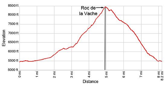
Hike Facts
- Distance: 8.2 miles (loop)
- Elevation: 5,480-ft. - 8,468-ft.
- Elevation Gain: 1,895-ft. - 2,988-ft.
- Difficulty: strenuous
- Trail Highlights: See Trail Intro
- Basecamp(s): Zinal
- Region: The Valais
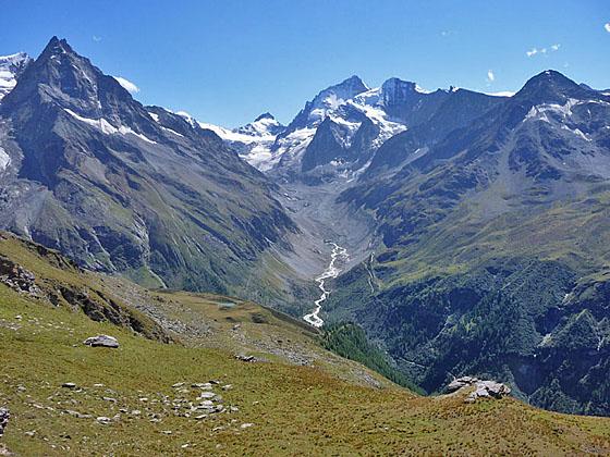
This steep hike leads to Roc de la Vache, a panoramic overlook high above the east side of the Zinal Valley.
From Zinal to Lac d’Arpitetta
Distance from Trailhead: 4.1 miles (one way)
Ending/Highest Elevation: 7,375-ft.
Elevation Gain: 1,895-ft.
Note: This hike can be done in either direction. The description below describes the hike in the counter-clockwise direction, which is not quite as steep. Hiking the trail clockwise is steeper but you are facing up valley, which means the views to the head of the valley are in front of you. I’ve done the hike in both directions. My favorite option is to hike to the Roc de la Vache viewpoint after visiting the Cabane Arpitettaz.
This hike starts on Zinal's (5,479-ft.) main street. (See trailhead directions below.) Walk south (up valley) along the main street to a car park at 0.6 miles. Turn right (west) and cross the wood bridge over the La Navisence River, the river draining the Zinal Valley. On the west side of the river turn left (south) and continue walking up the Zinal valley toward the Petite Mountet (1-hr 50-min) and Grand Mountet (4-hr 10-min). The broad track ascends through pastures on easy grades with nice views of Besso towering above the east side of the valley.
Pass a junction at 1.7 miles with a route branching left toward Lac Arpitetta and the Arpitettaz Hut. We continue heading south on the track, which starts ascending on moderately-steep grades up a wooded hillside along the west side of the valley.
At 2.2 miles the trail travels by a pretty waterfall and then climbs a switchback. Soon the path reaches a junction at Le Vichiesso (6,109-ft.). Here a trail branches right toward the Petite Mountet (45-min). We continue along the main track toward Petite Mountet (1-hr), Roc de la Vache (2-hr 30-min), Grand Mountet (3-hr 20-min) and Arpitettaz Hut.
The grade eases at 2.5 miles as the trail ascends along the hillside. La Navisence tumbles down the rocky riverbed below the trail. Reach a junction at 2.9 miles and turn left (east) on the trail toward the Roc de la Vache, Grand Mountet and Arpitettaz. The trail to the right leads to the Petite Mountet Hut.
Our trail drops down to and crosses La Navisence River on a bridge. On the east side of the river is a “Y” intersection. Here we turn left toward Arpitettaz and Roc de la Vache. The trail to the right heads to Cabane du Grand Mountet.
Follow the trail a short distance as it curves to the right (east) and crosses a bridge over the Torrent de l'Arpitetta, a glacial stream draining the Arpitetta Valley, at 3.1 miles. On the north side of the stream the trail climbs steep switchbacks up a wooded hillside on the north side of the Arpitetta Valley.
At 3.5 miles the trees give way to grassy slopes and pastures of Le Chiesso, a small alp. From the Alp fine views open to Pigne de la Le, the Grand Cornier, Dent Blanche and Pointe de Zinal rising along the west side of the Zinal Valley. Besso, Blanc de Moming and Pointe Sud de Moming tower above the southeast side of the Arpitetta valley.
Beyond the Alp the trail climbs a long, steep switchback through low-lying shrubs and scattered trees, passing a junction with a route branching left that descends to Zinal. At 3.9 miles the trail curves to the right and reaches a “Y” intersection at Lac Arpitetta (7,375-ft.). (The lake is actually a short distance beyond the sign.) The trail to the left climbs to Roc de la Vache (1-hr 10-min) while the trail to the right (southeast) heads toward the Arpitettaz Hut (1-hr 40-min). At this point I suggest a detour to the Lac d'Arpitetta, which will add a quarter of a mile to the hike.
To visit the lake, turn right toward the Arpitettaz Hut and ascend along a gully with nice views of Besso. Reach Lac d'Arpitetta, a popular picnic spot, at 4.1 miles. The small lake boasts terrific views of the Weisshorn, Schalihorn, Pointe Sud de Moming, the Zinalrothorn, Blanc de Moming and Besso, forming the east and south sides of the beautiful glacial cirque at the head of the Arpitetta valley. The Pigne de la Le, Bouquetins, Grand Cornier, Dent Blanche and the Pointe de Zinal fill the skyline to the south.
To Roc de la Vache and back to Zinal
Distance from Trailhead: 8.2 miles (loop)
Ending/Highest Elevation: 8,468-ft.
Elevation Gain: 2,988-ft.
After soaking in the views continue along the trail as it heads east for about 300-ft. to a junction. Take the trail branching left toward Roc de la Vache (45-min) and the Cabane de Tracuit (2-hr 30-min), which ascends on moderate grades for 0.25 miles to join the main trail to Roc de la Vache. Turn right and follow the main trail as it ascends on very steep grades up the grassy slopes beneath the west face of Pointe d'Arpitetta. Along the way enjoy fine views of the Zinal Valley to the south and the Arpitetta valley to the southeast.
Reach Roc de la Vache (8,468-ft.) at 5.0 miles after gaining over 1,000-ft. from the lake. The viewpoint offers a superb perspective of the Zinal area. To the north Zinal lies cradled 3,000-ft. below on the valley floor while further to the north views extend down the Val de Anniviers to the Bernese Alps rising beyond the Rhone Valley. Across the valley to the west are the rugged profiles of the Garde de Bordon and Corne de Sorebois.
To the south Besso and the Pigne de la Le guard the entrance to the head of the Zinal valley. The Grand Cornier, Dent Blanche and the Pointe de Zinal, adorn with glaciers, tower above the west side of valley. The Zinalrothorn, Moming massif and the Moming glacier dominate to the view to the southeast while Tete de Milon and the Pointe d’Arpitetta frame the Weisshorn at the head of the Arpitetta Valley.
After enjoying the views, descend northeast on the trail toward Zinal. The path drops into a grassy bowl and crosses the Torrent du Barme, a stream draining the slopes below Tete de Milon and the Diablon des Dames, at 5.2 miles. Beyond the stream the trail turns left (northwest) and descends to a junction at 5.3 miles. Here a trail branches right (northeast) toward the Cabane de Tracuit, located on the ridge between Tete de Milon and the Diablon des Dames. We continue straight ahead toward Zinal on a path dropping down very steep switchbacks along the north side of a Torrent du Barme.
At 5.7 miles the trail turns right (north) away from the stream and continues its steep descent down long switchbacks accompanied by fine views of the peaks rising along the west side of the Zinal Valley. To the north are distant views of the Bernese Alps.
At 6.3 miles pass a junction with the Sentier des Arolles trail. We turn left and descend on switchbacks toward Zinal. Look up to see the Torrent du Barme plunging down the steep hillside as you descend.
The trail drops on very steep grades through pastures, passing a small Alp at 6.8 miles. Beyond the Alp descend a wide track on very steep switchbacks along the south side of a deep gully channeling the Torrent de Tracuit. Drop down to and cross the gully at 7.4 miles. On the north side of the stream the track skirts the east side of a large bowl and soon reaches a junction with Tracuit Street in Zinal. Follow the street as it switchbacks down the hillside on moderate grades, passing chalets and the Reka Zinal resort.
Reach a junction at 7.8 miles with Peterey Street and turn right (north/northwest). Follow Peterey Street to the center of Zinal at 8.2 miles. The post bus stop is on the left (west) side of the main street (one block to the west of Peterey Street) in the northern part of the village.
Walking in the Reverse Direction: If walking the route in the reverse direction, head south along the main street from the post office. Near the south end of the tennis courts, located on the right (west) side of the street, turn left on a side street. At the next street turn right (south) and walk south for about 0.3 miles to the corner of Peterey and Tracuit Street. Turn left onto Tracuit and follow the signs toward Roc de la Vache (4-hr) and Cabane Tracuit (5-hr).
Elevation Profile
Driving Directions
Directions in Zinal: From the Post Office/Bus stop in Zinal, walk south along Rue des Cinque 4000 (the town’s main street). The mileage in this description starts the hike a few blocks beyond, near the tennis courts and ice skating rink. Add 0.3 miles (round-trip) to the hike if you start from the bus stop.
From Grimentz to Zinal: From the Grimentz post, board the bus to Zinal and get off at the post office stop. If possible catch a direct bus to Zinal. Otherwise, take the Vissoie Bus to Vissoie where you will need to change for a bus headed up the valley to Zinal. The direct buses take 15 minutes. If you need to change in Vissoie the ride will take 58 minutes or longer.
Buses make several stops in Grimentz. Schedules are posted at the bus stops and are available online at the SBB website and the SBB app.
Trail Resources
Trail Intro / Trail Photo Gallery / Trail Map
Basecamp(s) Information:
Zinal
Region Information:
The Valais
Other Hiking Regions in:
Switzerland