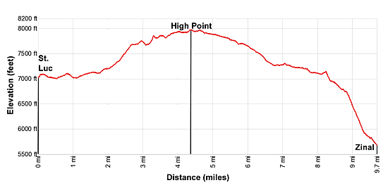
Hike Facts
- Distance: 9.7 miles (one way)
- Elevation: 7,145-ft. - 7,975-ft.
- Elevation Gain: 830-ft.
- Difficulty: moderate-strenuous
- Trail Highlights: See Trail Intro
- Basecamp(s): Zinal
- Region: The Valais
Highlights of this scenic walk between St. Luc and Zinal include magnificent views of the high peaks and glaciers gracing the skyline at the head of the Zinal Valley and panoramic views of the rugged summits towering above the Rhone and Anniviers Valleys.
St. Luc to Zinal

In St. Luc, take the funicular to Tignousa (7,145-ft.). (See trailhead directions below.) Outside the station find the trail signs and start hiking along the broad track heading southeast toward the Hotel Weisshorn and Zinal.
As you walk ignore the nearby ski lifts and pistes and instead focus on the great views to the south where the distinctively shape summit of the Matterhorn (14,692-ft.) towers above the peaks at the head of the Zinal Valley. To the southeast Les Diablons (11,840-ft.), the Bishorn (13,625-ft.) and the Weisshorn (14,783-ft.) rise above the ridge separating the Anniviers and Turtmann valleys. Below the trail vistas stretch southwest to Grimentz at the foot of the Moiry Valley.
The path, known as the Planets trail, travels through meadows and forest around a shallow side valley, passing short spur paths leading to sculptures of the sun and the planets. The meadows offer fine views of the ridge rimming the west side of the Anniviers valley and Les Diablerets, a flat topped peak, rising above the north side of the Rhone Valley. The white building setting atop a knoll across the valley is the Hotel Weisshorn.
At 0.8 miles pass a side trail at Chalet Blanc. A short distance beyond ignore trails branching right and dropping down to St. Luc. Soon you will start seeing rocks painted with the letter “Z” in yellow. These markers, in additional to the trail signs pointing toward Zinal, will help keep you on track.
Reach the Alp at Touno and a junction at 1.9 miles. Bear right on the trail toward the Hotel Weisshorn and Zinal. The path climbs through rocky meadows on moderate grades, reaching the Weisshorn at 2.9 miles. The circa 1880’s Victorian Hotel set atop a grassy knoll features panoramic views of the high peaks towering above the Rhone and Anniviers Valleys.
Behind the hotel is the continuation of the trail to Zinal. The undulating path ascends along meadow-clad slopes beneath the rugged Points de Nava ridge with more fine views. Depending on the time of year, patches of heather and clusters of fireweed enliven the scene.
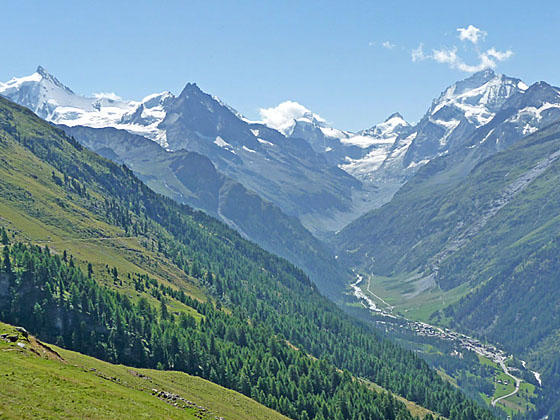
Near the high point on the hike views slowly unfold to the magnificent cirque at the head of the Zinal Valley, formed by Dent Blanche (14,294-ft.), Pointe de Zinal (12,431-ft.), Mont Durand (12,182-ft.), the Ober Gabelhorn (13,330-ft.) and Le Besso (12,001-ft.). The summit of the Matterhorn rises beyond the head of the cirque. Glaciers cling to the high peaks and the Zinal Glacier spills down the valley beneath the cirque.
Reach the high point (7,975-ft.) on the trail at 4.3 miles. The path now descends on easy grades with ever evolving and expanding views of the high peaks at the head of the valley. Soon the Zinalrothorn (13,848-ft.) and Blanc de Moming (11,936-ft.), along with the Moming Glacier, join the scene.
At 4.5 miles the trail briefly travels along a farm road before branching right onto the continuation of the trail. A large rock painted with the word Zinal and red/white slashes mark the trail.
The meadows along this section of the trail are a great place to stop and take a break to enjoy the magnificent views. Below us the Anniviers Valley splits into two branches; the Zinal Valley to the southeast and the Moiry Valley to the southwest. Grimentz lies at the foot of the Moiry Valley, beneath the rugged Becs de Besson (10,328-ft). The Zinal Valley, to southeast, is ringed by photogenic peaks clad in glistening glaciers. The Corne de Sorebois (9,501-ft.) rises above the confluence of the two valleys.
The path now continues its gentle descent, slowly curving to the left (southeast) as it follows the contours of a shallow side valley beneath the Montagne de Nava. At 4.9 miles reach the junction at Bella Le (7,874-ft.) where a trail branches left toward Forcletta and Gruben. Another path heads right, dropping down to Ayer on the valley floor. We stay on the path toward Barneuza and Zinal.
Gradually we lose our views as the path nears the head of the side valley. At 5.5 miles the trail crosses a steam on a wood bridge and then turns right, descending around the head of the valley on moderate grades. Along the way pass a second junction with a trail climbing to Forcletta and Gruben at 5.6 miles. A short distance beyond the path crosses a second stream on a bridge near an old building and then curves to the right (southwest), descending on easy grades.
At 6.4 miles the path leaves the side valley as it curves to the left (south/southeast), crosses a low ridge and emerges high above the Zinal Valley. Here breathtaking views reopen to the peaks towering above the head of the valley. The town of Zinal is visible on the valley floor. This area is another great place to take a break.
The trail now descends through meadows and then scree covered slopes before curving left into the Barneuza Valley. Travel through pastures and then around the small alp of Sierra Zinal, ignoring the signed trail branching right and dropping down to Ayer on the valley floor.
Beyond the alp the path descends to cross a stream draining the Barneuza valley and then passes a few cement buildings, part of a hydroelectric project. Soon the trail emerges from the side valley and begins a descent on easy to moderate grades through meadows and clusters of tree. Below are views of a large settling pond in Mottec, another part of the hydro system powering the Zinal and Anniviers Valleys.
At 8.2 miles reach a junction with the Promenade des Arolles branching left. We bear right on the trail to Lirec and Zinal that descends on moderate to moderately-steep grades through trees to a wood gate at 8.7 miles. Go through the gate and continue the descent on very steep grades, passing through the alp at Lirec. Here an old two-track road and braided trails drop through the pastures. Both the trail and the road are very steep. Pick the route that looks best to you. Take a break as you descend to appreciate the fine views toward the head of the Zinal Valley.
Below the pastures the trail plunges back into the trees and goes through a second gate before continuing its relentless descent on switchbacks. The grade briefly abates at 9.25 miles as the path crosses a gully, passes a few buildings and then traverses an avalanche chute. Beyond the chute the path travels through a tunnel built beneath an avalanche control barrier.
The final steep descent ends at the parking lot of the Arellaz condo complex along the east side of Zinal. Walk to the road in front of the complex. Here signs direct you to the center of the village where you will find grocery stores, bakeries, outdoor stores, hotels and the bus station.
Elevation Profile
Driving Directions
From Zinal to St Luc, Bella Tola: From the post office in Zinal, board Bus #453 bound for Vissoie. At Vissoie Post change to Bus #454 to Chandolin, Poste. Get off the bus in St. Luc at the Bella Tola stop. The bus ride from Zinal to St. Luc takes 48 minutes.
From Grimentz to St Luc, Bella Tola: From one of the several bus stops in Grimentz, board Bus #452 bound for Vissoie Poste. At Vissoie Poste, change to Bus #454 to Chandolin, Poste. Get off the bus in St. Luc at the Bella Tola stop. The bus ride takes 46-53 minutes.
From the Bella Tola bus stop walk southeast (in the direction the bus is traveling) along the main road. Soon you will reach a hairpin curve. Exit the main road and follow the Route Vieux Village toward the funicular. You will see blue signs for the funicular marking the route. At the next intersection bear left (funicular signs mark the turn). Pass a small side street on the left, the Rue du Cervin. At the next street bear left and in a short distance turn the right onto the Route de Funiculaire. Again, all of these turns are marked with signs. Walk up the road (Route de Funiculaire) to the funicular station on your left. The walk should take about 9 minutes.
See the SBB website or download the app for the current schedule. See the Val Anniviers website for more information about the St. Luc Funicular schedule.
If Walking the Trail in Reverse
Directions to the Trailhead from Zinal: From the Pam Supermarket on the main street in Zinal (just south of the bus station), cross the street and take the steps leading up to the Poste Hotel. At the top of the stairs turn right (south), walk up the street past the Thrift Hotel and then turn left (east) on the next street. Follow this street as it passes a church (on your right) and a large hotel complex (on your left).
At the east end of the hotel take the path branching to the left (northeast) through the grass. The track climbs to meet a road near an intersection. Cross the street and head up the road directly in front of you. There is a sign post along the left side of the road pointing straight ahead (northeast) toward Lirec, Barneuza Alpage and Hotel Weisshorn. Walk in the direction indicated by the sign.
The road ascends between two large apartment complexes, Les Erables and Les Arellaz. Follow the road as it curves to the left behind Les Erables to meet a dirt road ascending the hill. This is the way to the Hotel Weisshorn, Forcletta Pass and St. Luc. (On the first part of this walk, follow the signs pointing toward Lirec, Barneuza Alpage and Hotel Weisshorn.)
Trail Resources
Trail Intro / Trail Photo Gallery / Trail Map
Basecamp(s) Information:
Zinal
Region Information:
The Valais
Other Hiking Regions in:
Switzerland