Mule Ears
The Mule Ears Spring trail travels through classic Chihuahuan Desert terrain along the foothills to the south of Trap Mountain to a spring set amid a lush oasis of cottonwoods, shrubs, ferns and cattails. Extend the hike by continuing toward Smoky Creek for great views of Mules Ears Peak.
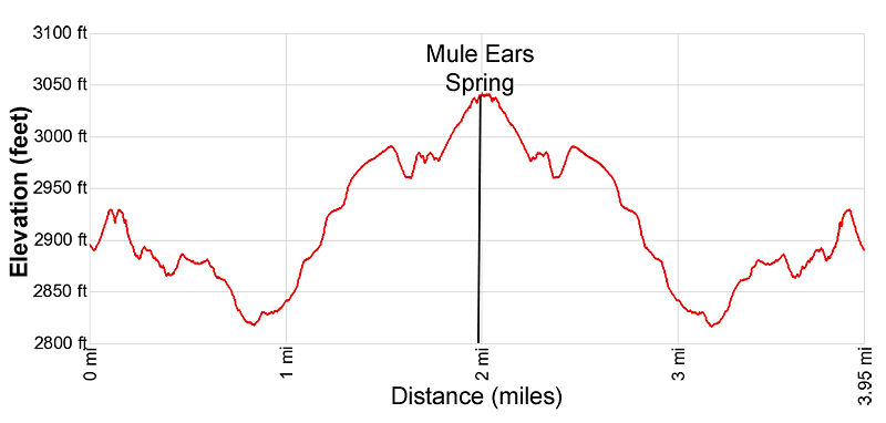
- Distance: 4.0 - 5.9 miles (RT)
- Elevation: 2,815-ft. at Trailhead
Maximum elevation - 3,040-ft. - Elevation Gain: 225-ft.
- Difficulty: easy-moderate
- Basecamp: Big Bend
- Region: Texas Parks
Trail Description - Mule Ears
Note: There are two destinations for this hike. Most people hike to Mule Ears Spring, a 3.95 miles round-trip hike with a 225-ft. elevation gain. The trail continues beyond the spring to vantage point with unobstructed views of the Mule Ears Peak for a 5.9 miles round-trip hike with a 530-ft. elevation gain.
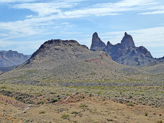
The Mule Ears trail starts at the Mule Ears Overlook parking lot (see driving directions below), located at the end of a spur road along the east side of the Ross Maxwell Scenic Drive. From the overlook enjoy nice views of Trap Mountain rising to the north and the twin pillars of Mule Ears Peak towering above the desert floor to the southeast.
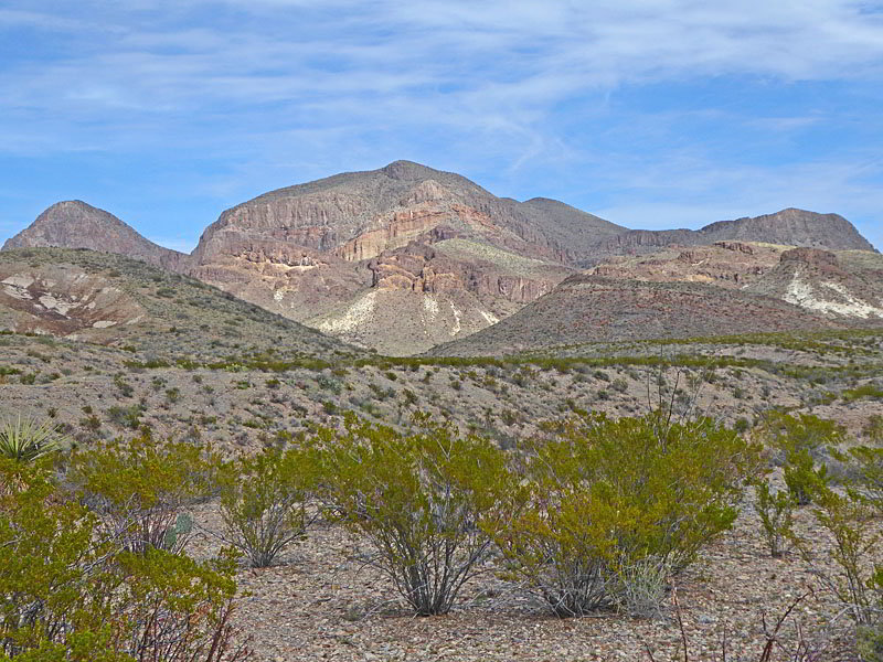
Follow the Mule Ears trail as it heads east/southeast, ascending to a viewpoint atop a low hill. Here we enjoy more fine views of the peaks and surrounding area. The path now descends through classic Chihuahuan Desert terrain, skirting the south facing slopes of Trap Mountain.
At 0.3 miles the trail dips in and out of a drainage before continuing along a bench to the south of Trap Mountain. At 0.7 miles the path drops into a wash and briefly follows the wash up stream (northeast) before climbing out of the wash to a bench at 1.1 miles. Atop the bench look left (north) to see Goat Mountain. The cottonwood trees in the wash below the trail mark the location of Trap Springs. Intervening hills now obscure all but the top of the Mule Ears summit.
The path now ascends along the bench to the south of the wash before dropping back into the wash at 1.55 miles. Cross the wash and them ascend northeast on easy grades that soon steepen. At 1.9 miles reach the remains of an old stone corral. This corral was on one of the old Castolon Ranch properties.
Follow the trail as it skirts the south side of the corral, passes a metal pipe and soon reaches a trail junction. Straight ahead is the spur trail to Mule Ear Springs. To the right is the continuation of the Mule Ears trail toward Smoky Creek.
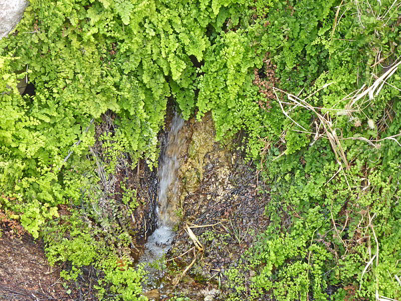
Walk straight ahead toward Mule Ears Spring. The vegetation thickens and the path soon reaches the spring at 1.975 miles. The spring is set amid cottonwood trees, shrubs ferns and cattails. After exploring the area around the springs, retrace your steps to the trailhead for a 3.95 miles hike.
Hikers looking for a longer day can continue on the Mule Ears trail toward Smoky Creek. This undulating trail heads southeast, crossing benches and two washes to reach a viewpoint to the north of Mule Ears Peak (3,425) at 2.95 miles. This vantage point offers terrific, unobstructed views of the distinctive twin pillars of eroded rhyolite dikes known as Mule Ears, once part of the core of a volcano.
Turn around here and return to the trailhead for a 5.9 mile hike. Beyond the viewpoint the trail drops into Smoky Creek’s broad wash. Note: There are two destinations for this hike. Most people hike to Mule Ears Spring, a 3.95 miles round-trip hike with a 225-ft. elevation gain. The trail continues beyond the spring to vantage point with unobstructed views of the Mule Ears Peak for a 5.9 miles round-trip hike with a 530-ft. elevation gain.
The Mule Ears trail starts at the Mule Ears Overlook parking lot (see driving directions below), located at the end of a spur road along the east side of the Ross Maxwell Scenic Drive. From the overlook enjoy nice views of Trap Mountain rising to the north and the twin pillars of Mule Ears Peak towering above the desert floor to the southeast.
Follow the Mule Ears trail as it heads east/southeast, ascending to a viewpoint atop a low hill. Here we enjoy more fine views of the peaks and surrounding area. The path now descends through classic Chihuahuan Desert terrain, skirting the south facing slopes of Trap Mountain.
At 0.3 miles the trail dips in and out of a drainage before continuing along a bench to the south of Trap Mountain. At 0.7 miles the path drops into a wash and briefly follows the wash up stream (northeast) before climbing out of the wash to a bench at 1.1 miles. Atop the bench look left (north) to see Goat Mountain. The cottonwood trees in the wash below the trail mark the location of Trap Springs. Intervening hills now obscure all but the top of the Mule Ears summit.
The path now ascends along the bench to the south of the wash before dropping back into the wash at 1.55 miles. Cross the wash and them ascend northeast on easy grades that soon steepen. At 1.9 miles reach the remains of an old stone corral. This corral was on one of the old Castolon Ranch properties.
Follow the trail as it skirts the south side of the corral, passes a metal pipe and soon reaches a trail junction. Straight ahead is the spur trail to Mule Ear Springs. To the right is the continuation of the Mule Ears trail toward Smoky Creek.
Walk straight ahead toward Mule Ears Spring. The vegetation thickens and the path soon reaches the spring at 1.975 miles. The spring is set amid cottonwood trees, shrubs ferns and cattails. After exploring the area around the springs, retrace your steps to the trailhead for a 3.95 miles hike.
Hikers looking for a longer day can continue on the Mule Ears trail toward Smoky Creek. This undulating trail heads southeast, crossing benches and two washes to reach a viewpoint to the north of Mule Ears Peak (3,425) at 2.95 miles. This vantage point offers terrific, unobstructed views of the distinctive twin pillars of eroded rhyolite dikes known as Mule Ears, once part of the core of a volcano.
Turn around here and return to the trailhead for a 5.9 mile hike. Beyond the viewpoint the trail drops into Smoky Creek’s broad wash.
Elevation Profile
Driving Directions
From the Big Bend National Park Headquarters at Panther Junction: From Panther Junction, at the intersection of the Persimmon Gap Road and the West Entrance Road, head west on the West Entrance (Gano Springs) road toward Basin Junction. Follow the road for 12.7 miles and then turn left on the Ross Maxwell Scenic Drive. Continue on the Ross Maxwell Scenic Drive for 15.4 miles and then turn left onto the Mule Ears Overlook Road. The road ends in 0.5 miles at the Mule Ears Overlook and Mule Ears Spring trailhead.
From the Chisos Mountain Lodge Area: Head northeast on Chisos Basin Road for 6.4 miles and then turn left onto the West Entrance Road. Follow the West Entrance Road for 9.5 miles and the turn left onto the Ross Maxwell Scenic Drive. Drive 15.4 miles on the Ross Maxwell road and then turn left onto the Mule Ears Overlook Road. The road ends in 0.5 miles at the Mule Ears Overlook and Mule Ears Spring trailhead.
Trail Resources
- Trail Photo Gallery
- Trail Maps
- Basecamp(s) Information: Big Bend
- Region Information: Texas Parks
- Other Hiking Regions in: Texas