Cohab Canyon 
Distance: 1.7 - 2.2 miles
Fruita District, Capitol Reef National Park, near Capitol Reef in South Central Utah
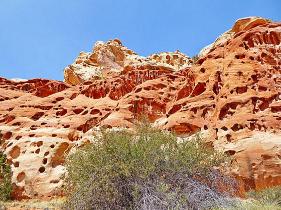
Walls of Cohab Canyon
The short steep climbs leads to a colorful hanging canyon with sculpted, pockmarked walls that look like geological Swiss cheese. Short, narrow side canyons and two overlooks with views of the Fremont River Valley and Fruita add interest to the hike that ends at UT-Highway 24.
- Distance: 1.7 - 2.2 miles (RT)
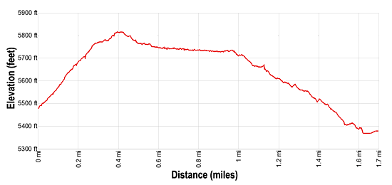
- Elevation: 5,480-ft. at Trailhead
Maximum elevation - 5,820-ft. - Elevation Gain: 340-ft.
- Difficulty: moderate
- Basecamp: Capitol Reef
- Region: South Central Utah
Trail Description - Cohab Canyon
Distances:
- 1.7 miles point-to-point hike to Highway 24
- 2.2 miles RT to Junction with the Fryingpan trail and back
- Add 0.4 miles to North Overlook
- Add 0.5 miles to South Overlook
- Add 1.1 miles to both Overlooks
From the Fruita parking area (see driving directions below), walk southeast along Scenic Drive to the Cohab Canyon trailhead on the left (east) side of the road. The trail immediately starts gaining altitude, climbing steep switchbacks with great views of the Fruita Area and the red rock cliffs towering above the north side of the Fremont River and Highway 24.
After 0.25 miles the grade eases a bit as the trail turns right (south) and travels along sheer Wingate cliffs to the head of Cohab Canyon, a hanging valley. After going over a minor hump the trail drops into Cohab Canyon on easy grades.
The narrow canyon’s terracotta and beige walls are highly eroded and in place look like geologic Swiss cheese. Initially the trail travels down the sandy wash scattered with junipers and pinyon pines. Several side canyons invite exploration.
At 0.7 miles the canyon widens and the walls become lower. Soon obstacles in the wash prevent further progress. The trail now leaves the wash and travels on slickrock along the left (north) side of the canyon.
At 1.0 mile reach a junction. To the left is a trail to two overlooks that climbs the canyon’s north wall and then spits after 0.3 miles. The trail to the right heads north to an overlook with views of the Fremont River Canyon in 0.1 miles and the trail to the left leads southwest to an overlook with views of the Fruita area in 0.2 miles. The total round-trip to visit both overlooks is 1.1 miles.
Beyond the junction with the overlooks the Cohab Canyon trail continues straight ahead toward Utah Highway 24. In a short distance the path drops into the wash and then climbs a short distance up the canyon’s south wall to a junction with the Fryingpan Trail. You now have a choice, either to retrace your steps to the trailhead or continue to Highway 24.
I personally prefer to retrace my steps to the trailhead, enjoying the colorful canyon from a slightly different perspective. This options results in a 2.2 mile round-trip hike or a 3.3 miles hike if you also visit the overlooks.
Hikers with a prearranged car shuttle can continue along the Cohab trail by turning left at the junction. (The Fryingpan Trail, to the right, eventually leads to Cassidy Arch and the Grand Wash.) The trail now descends on easy grades along a bench above the south side of the wash. At 1.3 miles the wash widens and views open to the white Navajo sandstone formation towering above the north side of the Fremont River Valley.
Soon the trail curves to the left, crosses a drainage and then briefly descends along a bench before dropping down to Utah Highway 24 at 1.6 miles. You are now just east of the Hickman Bridge parking area. To reach the park lot, carefully cross the highway and then turn left, walking along the shoulder of the road to the parking area at 1.7 miles.
Elevation Profile
Driving Directions
Capitol Reef Visitor Center to Campground/Scenic Drive Trailhead: Turn right out of the Visitor Center on Campground Road and drive for 1.0 miles to the large parking area on the left (east) side of the road. Along the way Campground Road turns into Scenic Drive. Park in the lot and then walk 0.1 mile south on Scenic Drive to the Cohab Canyon trailhead, located on the left (east) side of the road. Along the way you will pass the Gifford Homestead and the Fruita Barn.
Capitol Reef Visitor Center to Hickman Bridge/Highway 24 Trailhead: Turn left out of the Visitor Center on Campground Road and after 100-ft. turn right onto UT 24 East. Drive 1.9 miles and turn left into the Hickman Bridge/Rim Overlook/Navajo Knobs trailhead parking lot. The trail starts on the northeast side of the parking area. This is a very small parking lot and can be very busy. There is a fair amount of turnover since most people only hike to Hickman Bridge.
Trail Resources
- Trail Photo Gallery
- Trail Maps
- Basecamp(s) Information: Capitol Reef
- Region Information: South Central Utah
- Other Hiking Regions in: Utah