Details: Navajo Knobs and Rim Overlooks 
Distance: 4.5 - 9.4 miles (round trip)
Fruita District, Capitol Reef National Park, near Capitol Reef in South Central Utah
Hike Facts
- Distance: 4.5 - 9.4 miles (round trip)
- Elevation: 5,340-ft. - 6,920-ft.
- Elevation Gain: 1,580-ft.
- Difficulty: moderate-strenuous
- Trail Highlights: See Trail Intro
- Basecamp(s): Capitol Reef
- Region: South Central Utah
Another great hike in Capitol Reef, the Navajo Knobs trail ascends along a bench with non-stop, birds-eye-views of some of the parks iconic landmarks along with impressive vistas of Waterpocket Fold. Distant views extend to the Henry Mountains and beyond.
Trailhead to Navajo Knobs

From the Hickman Bridge / Rim Overlook / Navajo Knobs trailhead, the path heads east along a low cliff, briefly following the Fremont River as it heads downstream. Soon the trail curves left (north/northwest), climbing 120-ft. on moderately-steep switchbacks through a break in the cliff and then up grassy hillsides to the junction with the Hickman Bridge trail, branching left, at 0.3 miles.
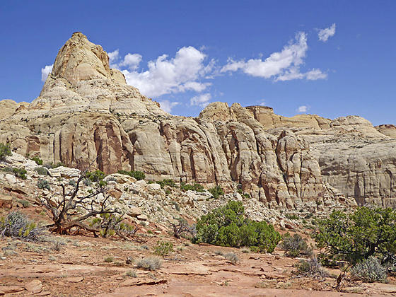
Turn right (north) at the junction on the Navajo Knobs trail. In a short distance crest the top of the hill and then descends to cross a dry wash. Along the way enjoy nice views of the Navajo sandstone formations to the north. The path briefly travels along the right (east) side of the wash before turning left (west) at 0.6 miles and ascending along grass and sandstone benches scattered with black basalt and andesite boulders. Here views stretch south/southeast to Pectols Pyramid (6,526-ft.) and Fern’s Nipple (7,050-ft.). Sheer Navajo sandstone cliffs tower above the trail to the north.
Reach Hickman’s Bridge Overlook at 0.9 miles. The overlook enjoys great views of the 125-ft. tall natural bridge with a span of 133-ft. carved out of the Kayenta formation. Photogenic knobs and cliffs rise above the overlook. To the south are a sea of white knobs, domes and buttes.
Beyond the overlook the boot-beaten trail briefly turns to the north as it crosses the drainage at the foot of a side canyon. The path now ascends along the bench in a westerly direction, ducking in and out of three more side canyons as it follows the contours of the landscape. Rock cairns mark the trail as it crosses sections of slickrock. Your progress will be slowed as you stop to take in the ever evolving views of the heart of Capitol Reef to the south/southeast and the formations to the north of the trail.
At 2.25 miles reach the Rim Overlook offering birds-eye-views of the Fruita Section of Capitol Reef, an oasis of greenery located directly below the viewpoint. The Henry Mountains form a scenic background for tilted landscape of the Waterpocket Fold where white Navajo sandstone knobs, blocks and domes are layered atop multi-hued layers of Kayenta, Wingate, Chinle and Moenkopi formations.
From the Rim Overlook the trail turns sharply right (northwest) and descends on easy grades to cross a drainage. Here the trail again turns in a westerly direction and resumes it ascending traverse that echoes the contours of the bench. This section of the route crosses large expanses of slickrock. Keep an eye out for the cairns marking the route as it twists in and out of small drainages and around pour-offs.
At 2.9 miles the trail again turns sharply right (northwest), descending on an undulating trail above a large side canyon. Below you will see the Castle (6,312-ft.), a distinctive red Wingate formation sitting atop a rugged butte.
At 3.6 miles the descent abates as the trail crosses the drainage above the Castles and then curves to the left (west/southwest), ascending on moderately steep grades along a bench that curves around massive sandstone domes and blocks with sheer cliff. As you climb turn around for great views back at your route.
At 4.3 miles the grades briefly abates. To the west views open to the Navajo Knobs. Soon the climb resumes as the route arcs around another drainage. At 4.6 miles the trail swings to the right and follows a cairned route that climbs steeply up the backside of the Navajo Knobs to an overlook at 4.7 miles. Some people may find the climb to the top is out of their comfort zone. If so, enjoy the views from the bench in front of Navajo Knobs.
Views from overlook stretch west/northwest to Thousand Lake Mountain and east to the Henry’s. Below you to the southeast are the Castles and Fruita. Look closely and you should see Scenic Drive. This high viewpoint offers a fascinating perspective on how tilting and uplifting created Waterpocket Fold and how erosional forces subsequently sculpted the surrounding landscape.
When you are done taking in the views retrace your steps to the trailhead for a 9.4 miles round-trip hike.
Travel along this trail is only recommended during spring and the fall when temperatures are cooler. There are no dependable water sources along the trail so carry plenty of water. This trail traverses slickrock ramps, marked with rock cairns. Make sure you pay attention to the cairns to stay on course.
Elevation Profile
Driving Directions
Capitol Reef Visitor Center: Turn left out of the Visitor Center on Campground Road and after 100-ft. turn right onto UT 24 East. Drive 1.9 miles and turn left into the Hickman Bridge/Rim Overlook/Navajo Knobs trailhead parking lot. The trail starts on the northeast side of the parking area. This is a very small parking lot and can be very busy. There is a fair amount of turnover since most people only hike to Hickman Bridge.
Trail Resources
Trail Intro / Trail Photo Gallery / Trail Map
Basecamp(s) Information:
Capitol Reef
Region Information:
South Central Utah
Other Hiking Regions in:
Utah