Details: Lower Escalante River Trail 
Distance: 4.0 - 14.0 miles (round trip)
Grand Staircase-Escalante National Monument, near Escalante in South Central Utah
Hike Facts
- Distance: 4.0 - 14.0 miles (round trip)
- Elevation: 5,190-ft. - 5,760-ft.
- Elevation Gain: 105-ft. - 570-ft.
- Difficulty: moderate
- Trail Highlights: See Trail Intro
- Basecamp(s): Escalante
- Region: South Central Utah
A scenic canyon with an interesting natural bridge, an arch, rock art and a small ruin make for a nice day hike in the Grand Staircase-Escalante National Monument.
To the arch
Distance from Trailhead: 4.0 miles (round trip)
Ending/Highest Elevation: 5,295-ft.
Elevation Gain: 105-ft.
The trailhead is located 14.4 miles east of Escalante, Utah off Utah 12, just north of the bridge over the Escalante River (see driving directions below). From the trailhead located at the south end of the parking area, walk south and wade across the Escalante River. Hikers should not attempt to cross the river during high water conditions. If in doubt, check with the Escalante Interagency Visitor Center.
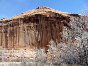
On the south side of the river the trail turns (right) west. Follow the trail as it travels on easy grades up the broad canyon on the bench to the south of the river. Along the way enjoy nice views of the sandstone walls decorated with desert varnish rising 400-ft. above the canyon floor. Cottonwoods, willows, tamarisk and grasses grow along the side of the river while the benches are clad in grasses, sagebrush, juniper and scrub growth.
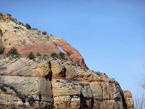
As you head up the canyon the trail crosses the river at 0.8 miles, 1.1 miles and 1.4 miles to short-cut meanders in the river. Just beyond the last crossing look up the canyon to the southwest to see natural arch high along the canyon’s south wall.
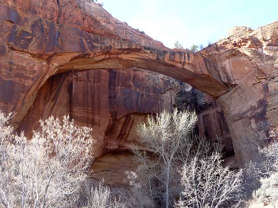
The trail now cuts southwest across the bench. Ahead, in a bay along the south wall, is the Escalante Natural Bridge. Reach the viewpoint for the bridge on the north side of the river at 1.6 miles. The 130-ft high bridge, with a span of 100-ft., serves as the entrance to a deep alcove on the south wall. You can either cross the river here for a closer view of the bridge or follow the trail up canyon for a tenth of a mile to a crossing. On the south side of the river a trail heads back down canyon to the bridge.
After marveling at this amazing span, continue up the canyon. At 1.9 miles, just before the trail crosses back to the north bench, look for an alcove with a small ruin and rock art along the south wall. On the wall along the back of the alcove is a red pictograph of a long squiggly red line. One wonders if the pictograph depicts the river. Unfortunately there is also graffiti defacing the back wall.
Please remember not touch rock art panels as the oil on your fingers can speed the erosion of the rock art. Do not vandalize the panels by taking latex mold prints or rubbings from rock art or adding modern additions.
Near the base of the wall below the ruins are some excellent petroglyphs that include a sun, a row of human-like figures holding hands, two foot prints and geometric forms. Some of the human figures in the panel are wearing headdresses and carrying shields.
The ruins and the rock art are very near the natural arch we seen earlier from a distance. To see the arch, follow the trail as it crosses the river. On the north side of the river, about 2.0 miles from the trailhead, stop and look up at the south wall to see the natural arch from a different perspective. This is a good turn around point for people looking for a short day hike.
To Death Hollow
Distance from Trailhead: 14.0 miles (round trip)
Ending/Highest Elevation: 5,390-ft.
Elevation Gain: 200-ft.
If time and energy permit continue wandering up the canyon as far as you like, admiring the sheer sandstone walls streaked with desert varnish. At 2.4 miles pass the confluence with Sand Creek. Reach a section of heavy vegetation at 3.0 miles where it is best to follow the trails along the south side of the canyon. A half a mile further the canyon narrows. Between this point and Death Hollow at 7.0 miles, the trail traverses sections of thick vegetation where it may be easier to walk in the river.
See the description of the Escalante River hike if you wish to continue up canyon beyond Death Hollow.
Be forewarned that the hike requires frequent river crossing so be prepared to get your feet wet. Before setting out, check on water levels and current conditions with the Escalante Interagency Visitor Center at 775 Main Street in Escalante, Utah.
Note: Due to the amount of walking in water that is required, this hike is best done during warm weather months to avoid hypothermia. High water levels during spring runoff or flash floods may make walking in the river corridor impossible. Hikers should not attempt to walk in the river when water levels exceed knee depth. Hikers must be extremely cautious during flash flood season. The Escalante River drains a large area and is prone to big floods which may cause the river to rise rapidly due to runoff from side canyons. Biting deer flies can be bad in the late spring/early summer. Wear long pants to avoid bites.
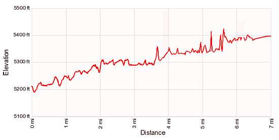
Elevation Profile
Driving Directions
From Escalante, UT: From the intersection of Main Street and Center Street in downtown Escalante, drive east/southeast on Main Street (Utah 12 E) for 14.4 miles and turn left (west) into the signed trailhead parking area. The trailhead parking area is located just after crossing the bridge over the Escalante River.
From Boulder, UT: From the intersection of the Burr Trail Road and Utah 12 (near the Burr Trail Grill), head south on Utah 12 W for 12.5 miles and turn right (west) into the signed trailhead parking area. The trailhead parking area is located just after crossing the bridge over the Escalante River.
Trail Resources
Trail Intro / Trail Photo Gallery / Trail Map
Basecamp(s) Information:
Escalante
Region Information:
South Central Utah
Other Hiking Regions in:
Utah