Details: Zebra Canyon and Tunnel Slot 
Distance: 5.3 - 7.2 miles (round trip)
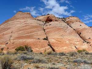
Grand Staircase-Escalante National Monument, near Escalante in South Central Utah
Hike Facts
- Distance: 5.3 - 7.2 miles (round trip)
- Elevation: 5,350-ft. - 5,125-ft.
- Elevation Gain: -225-ft.
- Difficulty: easy-moderate
- Trail Highlights: See Trail Intro
- Basecamp(s): Escalante
- Region: South Central Utah
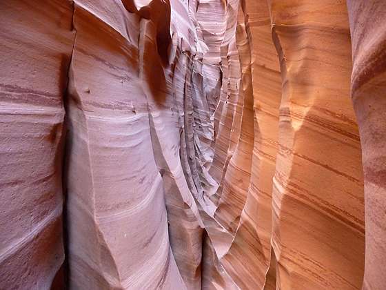
Beautiful Zebra Canyon, a narrow, convoluted slot streaked with pink and white stripes, will delight hikers of all ages. Combine the hike with nearby Tunnel Slot, a long narrow slot, for a great day hike down the Hole in the Rock Road.
To Zebra Canyon
Distance from Trailhead: 5.3 miles (round trip)
Ending/Highest Elevation: 5,125-ft.
Elevation Gain: -225-ft.
Note: This is an unmarked route. Make note of landmarks as you hike to facilitate finding your way back to the trailhead.
The route to Zebra Canyon starts 8.0 miles down the Hole in the Rock Road. (See driving directions below). From the parking area near the cattle guard, cross to the east side of the road and follow a boot beaten path east through scrub growth and junipers with distant views of Red Breaks. At 0.6 miles the route intersects the wash of Halfway Hollow. Initially the route does not travel in the sandy wash but instead periodically cuts across the wash and then traverses the adjacent benches to cut off meanders and walk along packed sand paths.
After walking a little over a mile Halfway Hollow starts looking less like a draw and more like a real canyon with sculpted sandstone walls. Watch for the boot beaten path that exits the wash at 1.5 miles. The trail now follows an ascending traverse along the north bench. The route reaches the high point on the bench at 1.9 miles. Here views extend east/northeast to the sandstone walls and formations along Harris Wash.
Descend the bench and reach Harris Wash at 2.0 miles. (Turn around and make note of the visible landmarks so you do not miss this turn on the return leg of the hike.) Turn left (northeast) and hike up the wide wash. The going is slow as you slog through the deep sandy wash.
Walk at tenth of a mile to a fork. Here Harris Wash curves left (northwest). We stay right and head into a side drainage. In a short distance a boot beaten path exists the wash and travels along the right (east) bench where the walking is considerably easier.
Travel along the side drainage for 0.4 miles. Soon you will see a narrow opening at the end of the drainage. This is Zebra Canyon. The canyon is short and quickly narrows. It is best to leave your backpack at the entrance to the slot. In places you will need to scramble over obstacles to work your way further up the canyon. The slot ends in about 0.25 miles at an impassable pour-off.
Nature’s artistry is finely displayed in this stunning slot. The further you go up the canyon the better it gets. The walls are decorated with intricate patterns of pink and white stripes. Wind and water have sculpted the walls into undulating surfaces. Cross cuts in the rock face twist and bend the patterns.
After exploring the slot retrace your steps to Harris Wash. If time and energy permits I suggest taking a side trip to Tunnel Slot.
To Tunnel Slot
Distance from Trailhead: 7.2 miles (one way)
Ending/Highest Elevation: 5,125-ft.
Elevation Gain: -225-ft.
To visit Tunnel Slot turn left (south) and head down Harris Wash. In a short distance you will see a boot beaten path that climbs the bench on the east side of the wash. This trail cuts off a sandy slog along a meander in Harris Wash.
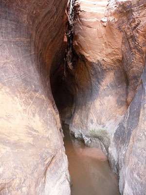
Continue down Harris Wash, opting to walk along the adjacent benches wherever possible to stay out of the deep sand in the wash. After walking a little over a mile from the mouth of Zebra Canyon you will see a north trending side canyon opening on your left. Turn left (north) and travel up the side canyon for 0.2 miles to Tunnel Slot. The “tunnel” slot is over 200-ft. long and is usually filled with water. Depending on the temperate and the time of year a wade through the tunnel may be a welcome relief from the hot sun.
When you are done playing in Tunnel Slot retrace your steps up Harris Wash and Halfway Hollow to your vehicle, at distance of a little over 3 miles from the mouth of Tunnel Slot. Total distance of the hike visiting both Zebra Canyon and Tunnel Slot is 7.2 miles.
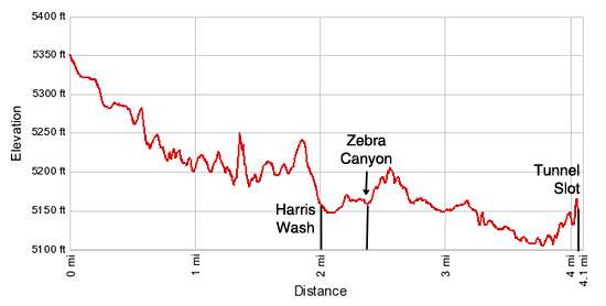
Elevation Profile
Driving Directions
From Escalante, UT: From the intersection of Main Street and Center Street in downtown Escalante, drive east/southeast on Utah 12 E (Main Street) for 4.9 miles and turn right on the Hole in the Rock Road. Follow the dirt road for 8 miles and turn right into an obvious parking area adjacent to a cattle guard on the road. The trail starts on the east side of the Hole in the Rock Road.
From Boulder, UT: From the intersection of the Burr Trail Road and Utah 12 (near the Burr Trail Grill), head south on Utah 12 W for 21.6 miles and turn left on the Hole in the Rock Road. Follow the dirt road for 8 miles and turn right into an obvious parking area adjacent to a cattle guard on the road. The trail starts on the east side of the Hole in the Rock Road.
Trail Resources
Trail Intro / Trail Photo Gallery / Trail Map
Basecamp(s) Information:
Escalante
Region Information:
South Central Utah
Other Hiking Regions in:
Utah