Details: Delicate Arch 
Distance: 3.1 miles (round trip)
Arches National Park, near Arches in Southeast Utah
Hike Facts
- Distance: 3.1 miles (round trip)
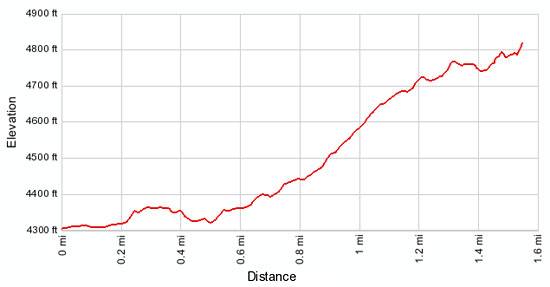
- Elevation: 4,300-ft. - 4,850-ft.
- Elevation Gain: 550-ft.
- Difficulty: moderate
- Trail Highlights: See Trail Intro
- Basecamp(s): Arches / Moab
- Region: Southeast Utah
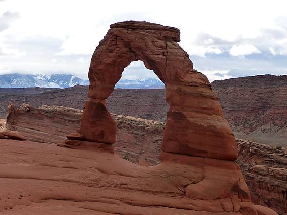
A short hike to a stunning, iconic arch perched on the edge of a huge sandstone bowl and framed by the scenic La Sal Mountains.
Trailhead to Delicate Arch
The path to Delicate Arch starts on the northeast side of the trailhead parking area (see driving directions). Follow the broad dirt trail as it heads northeast. In 140 yards arrive at a spur trail branching left (north) to the Wolfe Cabin, the home of James Wesley Wolfe and his family between 1888 and 1910. Our trail continues straight ahead, crossing a footbridge over Salt Wash at 0.1 miles.
Just beyond the bridge is a trail junction. To the left (northwest) is the Petroglyph trail, a short trail leading to a small panel of petroglyphs on a rock face. The panel, depicting images of horses, hunters and big horn sheep, are believed to be drawn by Ute and/or Paiute Indians that once roamed the Salt Wash drainage. The trail to Delicate Arch continues straight ahead on easy grades through desert scrub.
Reach a second junction with the Petroglyph trail heading left at 0.2 miles. Again stay straight. Just beyond the second junction the trail ascends a pair of switchback to climb over a small hill and then resumes its easy traverse across the rolling landscape.
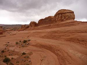
At 0.6 miles the trail ascends, on moderate grades, a scrub covered hillside that leads to a slickrock slope. Upon reaching the slickrock follow rock cairns up the moderately steep rock face. As you climb enjoy views of the red rock ridges and sandstone formations rising above scrub covered mesas to the south.
The grade moderates at 1.1 miles as the trail curves to the north, following an ascending traverse across a sandstone bench. Scattered Utah Junipers and desert shrubs grow amid small pockets of soil in the sandstone crevasses.
At 1.3 miles the trail curves to the east and soon makes a short steep climb to a wide ledge chiseled out of the side of a cliff. Follow the trail along the ledge for about 500-ft. (People with a fear of height might be uncomfortable on this short, exposed section of the trail.) To the north, below the trail, are bizarrely sculpted sandstone formations. As you reached the end of the exposed section look up to see a window, dubbed Frame Arch, in the cliff face above the trail.
So far the cliff rising to the south of the trail effectively blocks any views of Delicate Arch. Just beyond Frame Arch the cliff ends, revealing stunning views of Delicate Arch straddling the southern rim of a huge sandstone bowl. The La Sal Mountains, typically covered in snow during the spring, frame the view to the east. Red rock cliffs tower above the Cache Valley to the south.
Work your way around the bowl and stand beneath the abutments of the arch to appreciate the size of this incredible span, which measures 45-ft. high and 33-ft wide. Directly to the south of the arch a steep cliff plummets over 400-ft to the desert floor.
The bowl itself is a work of art. Multi-hued sandstone whorls surround a small basin. Knobs and fins decorate the sandstone ridge rising along the bowl’s northern rim.
When you are done marveling at this amazing work of Mother Nature, retrace your steps to the trailhead. If time and energy permit on the return trip, the 0.25 miles hike to see the petroglyphs is highly recommended.
For the best views, visit the arch in the early morning or around sunset. No matter what time of day you choose to hike to the arch you will not be alone. This is a very popular trail and the area around the arch can get quite crowded.
Spring and fall are the best seasons to hike to the arch. The hike is brutally hot in the summer, with temperatures often exceeding 100 degrees F. If you do go during the summer carry plenty of water (at least one quart per person) and try to hike the trail in the early morning or late afternoon when it is cooler.
Elevation Profile
Driving Directions
From Moab: Drive north on US 191-N for 4.6 miles and turn right (east) into the main entrance for Arches National Park. Follow the entrance road for 0.8 miles to the visitor’s center and entrance kiosk where you pay the entrance fees and pick up brochures and maps. Continue along Arches Scenic drive for 11.5 miles and turn right on Delicate Arch Road. Travel 2.3 miles along the road to the trailhead parking area on the left (north) side of the road.
From I-70: Take exit 182, signed for US 191 S/ Crescent Junction / Moab. Turn south onto US 191-S and travel for 26.9 miles and turn left (east) into the main entrance for Arches National Park. Follow the entrance road for 0.8 miles to the visitor’s center and entrance kiosk where you pay the entrance fee and pick up brochures and maps. Continue along Arches Scenic drive for 11.5 miles and turn right on Delicate Arch Road. Travel 2.3 miles along the road to the trailhead parking area on the left (north) side of the road.
Trail Resources
Trail Intro / Trail Photo Gallery / Trail Map
Basecamp(s) Information:
Arches / Moab
Region Information:
Southeast Utah
Other Hiking Regions in:
Utah