Details: Natural Bridges National Monument Loop Trail 
Distance: 8.6 miles (loop)
Natural Bridges National Monument, near Blanding in Southeast Utah
By: Diane Greer
Hike Facts
- Distance: 8.6 miles (loop)
- Elevation: 6,210-ft. - 5,650-ft.
- Elevation Gain: -560-ft.
- Difficulty: moderate
- Trail Highlights: See Trail Intro
- Basecamp(s): Blanding / Natbridge
- Region: Southeast Utah
This great loop hike in Natural Bridges National Monument visits three majestic natural bridges, crosses a high desert landscape and wanders along two scenic canyons with rock art panels and ancestral Puebloan ruins
Trailhead to Owachomo Bridge
Distance from Trailhead: 2.2 miles (one way)
Ending/Highest Elevation: 5,958-ft.
Elevation Gain: -252-ft.
The Natural Bridges loop trail can be hiked in either direction. I prefer saving the best for last so this description describes starting the loop at the Sipapu Bridge trailhead and heading southwest across the mesa toward Owachomo Bridge.
At the Sipapu parking area look south across the road and locate the start of the Mesa Trail heading southeast across the mesa. Follow the trail as it travels through a high desert landscape of pinion pines, junipers and sagebrush. Along the way the trail drops in and out of a minor drainages and crosses sections of slickrock, marked by rock cairns.
At 0.8 miles reach a signed junction where a segment of the Mesa Trail branches right (west) toward Kachina Bridge. Continue straight ahead on the Mesa Trail toward Owachomo Bridge. The trail crosses the loop road at 1.1 miles, drops in and out of two minor drainages, crosses the loop road again at 1.8 miles and then descends to the Owachomo Bridge parking area at 2.0 miles, after crossing the loop road one last time.
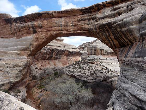
Owachomo means “rock mound” in Hopi, and is named after the rock formation on top of the east end of the bridge. From the parking area a short, easy spur trail leads to an overlook with good views of the bridge and the twin buttes called “The Bear’s Ears” to the east.
Return to the parking area from the overlook at head down the Owachomo Bridge trail. The moderately difficult trail descends steps and drops down slickrock ledges to the wash beneath the bridge, losing 190-ft. in 0.25 miles.
Owachomo is a stunning example of the forces of erosion. The bridge, just 9-ft. thick, is the most fragile and elegant of the monument’s three spans. It is also the smallest, with a height of 106-ft. and a span of 180-ft., and commonly through to be the oldest.
Owachomo to Kachina Bridge
Distance from Trailhead: 5.7 miles (one way)
Ending/Highest Elevation: 5,650-ft.
Elevation Gain: -560-ft.
Cross beneath the Owachomo Bridge and find the signed trail heading right (southwest) down Armstrong Canyon toward Kachina and Sipapu Bridges. Initially the cairned trail travels along slickrock ledges to the east of the wash but soon drops into the wash. During the course of the hike the trail along the canyon bottom will weave between the wash and it adjacent benches to circumvent obstacles in the wash and detour around pouroffs.
The canyon’s beautiful sandstone walls are stained with desert varnish. Juniper, pinion pine, sagebrush and desert scrub grow along the canyon’s floor and the ledges protruding from the sandstone walls. Cottonwoods, oaks, willows and grasses make an appearance in the wetter sections of the drainage.
Follow the trail as it echoes the canyon’s serpentine course. At 4.4 miles, look for a ruin nestled in an alcove along the canyon’s western wall. Soon the route passes an east trending side canyon and bends to the west, where a long meander travels around a gooseneck. As the canyon bends back to the east, the trail climbs a slickrock ledge along the south side of the canyon that bypasses a narrow pouroff and plunge pool at 5.3 miles.
Past the pouroff the trail travels along the slickrock ledge high above the wash. Soon views open to Kachina Bridge to the northwest. At 5.4 miles reach a junction with the trail descending from the rim to Kachina Bridge, branching to the right. Turn left and steeply descends slickrock slopes to the wash. Handrails, a short wood ladder and toes holes chiseled in the rock aid the descent.
A short distance to the northwest is Kachina Bridge, located at the confluence of Armstrong Canyon with White Canyon, 5.7 miles from the trailhead. The bridge is larger than Owachomo but smaller than Sipapu, with a span of 204-ft. and a height of 210-ft. It is the chunkiest of the three spans, with a thickness of 93-ft. Mother Nature is slowly sliming the Bridge. In June of 1992 approximately 4,000-tons of sandstone feel from the inside of the span.
Rock art, including both pictographs and petroglyphs are located along the base on both sides of the Bridge. To the southwest of the bridge is a trail climbing a steep sandy slope to an alcove sheltering a small ruin and more rock art.
Completing the Loop to Sipapu Bridge
Distance from Trailhead: 8.6 miles (loop)
Ending/Highest Elevation: 6,210-ft.
Elevation Gain: 560-ft.
After exploring the around the Kachina Bridge, go through the bridge and follow the trail as it heads up White Canyon. White Canyon is quite scenic, flanked by red and white sandstone walls stained with desert varnish. The trail meanders along the wash and across sandy benches, following the canyon’s twist and turns.
About a mile beyond Kachina Bridge scan the canyon’s northwestern wall for a small ruin, probably a granary, in a small alcove at 6.7 miles. A half mile beyond, at 7.2 miles, in an alcove on the canyon’s northwest wall is Horsecollar ruin. The well preserved ruin is named because the doorways of two granaries resemble horsecollars. The site, thought to be abandoned more than 700 years ago, includes a Kiva with its original roof and interior.
(Note: The Horsecollar Ruin Overlook trail provides a bird’s-eye view of the ruin. The short, mostly level trail begins from the loop road, shortly beyond the Sipapu trailhead.)
Beyond the ruins the trail passes the confluence of Deer Canyon at 7.4 miles and continues its circuitous course up White Canyon. At 7.9 miles, as the trail heads northeast around a bend, Sipapu Bridge springs into view. This massive span, the second largest natural bridge in the world, is 220-ft. high and spans 268-ft. In Hopi mythology a “sipapu” is an opening through which souls may pass to the spirit world.
At the base of the bridge, reached at 8.0 miles, a trail climbs steeply up slickrock friction pitches, with the aid of ladders and railing, to a series of switchbacks that ascend a rocky slope through junipers, pinion pines and scrub growth to a sandstone ledge. A spur trail heads right along the ledge to an overlook with stunning views of Sipapu Bridge.
After taking in the view head back to the main trail and follow the path along the ledge as it curves left (southeast) to a long wooden ladder. Ascend the ladder and then, in quick succession, climb two sets of metal stairs. The final section of the path to the parking area ascends moderately steep switchbacks up a slickrock slope. A series of notches chiseled in the slickrock facilitates the climb. Reach the rim in just under 0.6 miles after gaining about 440-ft. The total distance for the loop hike is 8.6 miles or 8.8 miles, including side trips.
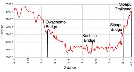
Elevation Profile
Driving Directions
From Blanding: Drive south on US 191 S for 4 miles and turn right (west) on UT-95 N. Follow UT-95 for 30.2 miles and turn right (north) on UT-275 N, signed for Natural Bridges. Follow UT-275 N for 4.5 miles to the Visitor Center, on the right, where you need to pay the entrance fee for the national monument. After paying the fee continue on UT-275 for 0.5 miles to a “T” intersection and turn right on the one-way loop road circling the monument. Drive along the loop road for 2.1 miles to the Sipapu Bridge trailhead parking area.
From Mexican Hat: Head east on US 163 N for 3.9 miles and turn left on (north) on UT 261 N. Follow UT261 N for 32.7 miles to its end at UT 95. (Note: a short section of UT-261 climbs steep gravel switchback up the Moki Dugway.) Turn left (west) on UT 95 N. Follow UT 95 N for 1.8 miles and turn right (north) on UT-275 N, signed for Natural Bridges. Follow UT-275 N for 4.5 miles to the Visitor Center, on the right, where you need to pay the entrance fee for the national monument. After paying the fee continue on UT-275 for 0.5 miles to a “T” intersection and turn right on the one-way loop road circling the monument. Drive along the loop road for 2.1 miles to the Sipapu Bridge trailhead parking area.
From Hite: Drive south on UT-95 S for 42.6 miles and turn left (north) on UT-275 N, signed for Natural Bridges. Follow UT-275 N for 4.5 miles to the Visitor Center, on the right, where you need to pay the entrance fee for the national monument. After paying the fee continue on UT-275 for 0.5 miles to a “T” intersection and turn right on the one-way loop road circling the monument. Drive along the loop road for 2.1 miles to the Sipapu Bridge trailhead parking area.
Trail Resources
Trail Intro / Trail Photo Gallery / Trail Map
Basecamp(s) Information:
Blanding / Natbridge
Region Information:
Southeast Utah
Other Hiking Regions in:
Utah