Details: Lathrop Trail 
Distance: 5.0 - 12.2 miles (round trip)
Island in the Sky District, Canyonlands National Park, near Canyonlands in Southeast Utah
Hike Facts
- Distance: 5.0 - 12.2 miles (round trip)
- Elevation: 6,120-ft. - 4,400-ft.
- Elevation Gain: -1,720-ft.
- Difficulty: strenuous
- Trail Highlights: See Trail Intro
- Basecamp(s): Canyonlands / Moab
- Region: Southeast Utah
This trail offers options for all levels of hikers as it travels through diverse landscapes with terrific view of the maze of canyons and red rock formation beneath the Island in Sky mesa. Far reaching vistas stretch east to the La Sal Mountains and south to the Abajo Mountains.
Trailhead to Canyon Rim
Distance from Trailhead: 5.0 miles (round trip)
Ending/Highest Elevation: 5,810-ft.
Elevation Gain: -650-ft.
From the trailhead parking area (see driving directions below) the Lathrop Trail heads southeast across Gray’s Pasture, an open grassland with Navajo sandstone outcroppings. Ranchers used the pasture for grazing sheep until the 1960’s when the area became Canyonlands National Park. As you cross the pasture enjoy fine views of the La Sal Mountains rising to the east.
After 0.5 miles the trail starts ascending on gentle grades. The ascent abates at 1.1 miles where the trail climbs over a low rise and then descends on easy grades toward the edge of the mesa. Near the edge of the mesa look left (east) to see a blue metal shack used by ranchers to store supplies.
At 1.4 miles the packed sand/dirt trail gives way to slickrock (Navajo Sandstone) as the trail curves to the left (east), traveling through an interesting area of sandstone domes and ridges interspersed with sandy areas sprinkled with junipers and pinyon pines. Rock cairns mark the trail where it crosses slickrock.
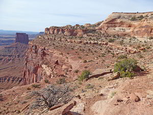
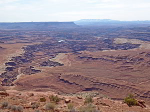
At 1.5 miles the trail reaches the edge of the Island in the Sky mesa. Here views open to the Colorado River flowing through a deep channel cut into the White Rim plateau. Dead Horse Point State Park, sitting atop a mesa, is seen to the northeast while the La Sal Mountains dominate the view to the east. The Abajo Mountains grace the skyline to the south.
The path now curves to the right (southeast) and starts descending through the Navajo Sandstone layer, dropping down slickrock slopes and sandy basins scattered with junipers and desert scrub. At 1.9 miles the path briefly abates as it crosses a packed sand bench.
At the edge of the bench (2.1 miles) the descent resumes as the path follows a circuitous route through Navajo Sandstone formations. Pay attention to the rock cairns marking the slickrock portions of the trail to stay on track. Along the way the trail travels near the edge of the canyon rim where great views open to the red rock formations rising above the White Rim plateau and the Colorado River.
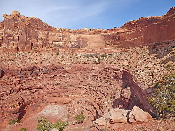
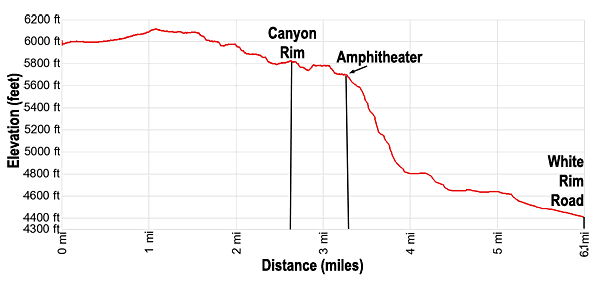
At 2.5 miles the path reaches Canyon Rim where terrific vistas include the a sea of red rock formations rising above the White Rim plateau, the Colorado River, Airport Tower and the La Sal and Abajo Mountains. There are also superb views of the walls beneath the rim. Here you can clearly see the Navajo Sandstone layer sitting atop a shelf formed from the Kayenta Formation which caps the sheer Wingate Sandstone walls beneath the shelf.
The Canyon Rim marks a natural break in the Navajo Sandstone formation where the trail drops down to the Kayenta Formation. This is a good turnaround point for parties looking for a shorter day or anyone with a fear of heights who will not be comfortable on the path dropping down to the shelf. (The shelf is wide and should not cause a problem for most hikers.)
To the Amphitheater
Distance from Trailhead: 6.5 miles (round trip)
Ending/Highest Elevation: 5,710-ft.
Elevation Gain: -1,100-ft.
Follow the path as it descends to and then travels along the shelf. The path initially heads west before turning to the south. The walk is accompanied by fine views of the landmarks seen from the Canyon Rim overlook.
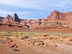
At 2.7 miles the trail climbs as it curves around a point and enters Lathrop Canyon where great views open to Airport Tower and Point 5,601-ft., rising to the south of the canyon. The path now heads northwest, traveling along talus slopes above the northeast side of the canyon.
At 2.9 miles the path swings to the right (north/northwest) and enters a north trending side canyon. Here the trail descends a rocky trail to a shelf set beneath a large amphitheater at the head of the side canyon at 3.25 miles. Along the way note the ledges and the rockslide spilling down the slopes beneath the head of the side canyon. The trail utilizes the ledges and rockslide to reach the White Rim road.
The amphitheater is another good turn around point for parties looking for a 6.5 mile round-trip hike or anyone who is not comfortable on the next section of the trail that drops steeply down the Wingate layer, losing over 900-ft. in 0.8 miles. There are several good places to sit along ledge beneath the amphitheater to have a snack while admiring the view.
To the White Rim Road
Distance from Trailhead: 12.2 miles (round trip)
Ending/Highest Elevation: 4,400-ft.
Elevation Gain: -2,400-ft.
The trail, marked with rock cairns, now switchbacks steeply down ledges. After descending over 200-ft. the path reaches a rockslide where a series of constructed switchbacks, some with steps, zig-zag down the steep slope. Use care as you descend. There is a lot of loose rock along the trail. One can only marvel at the amount of effort that has gone into building and maintaining this section of the trail.
Near the bottom of the slope the grade abates as the trail curves to the right (west) at 4.0 miles. The path now crosses the side canyon’s wash before swinging left (southeast) and dropping down to cross the Lathrop Canyon’s wash at 4.5 miles. As you descend this section of the trail you are traveling through the Chinle and Moenkopi layers.
Follow the path, actually an old road, as it traverses along the west side of the Lathrop wash and reaches a bench at 5.0 miles. This road was used to access Uranium mines in the canyon. (Stay away from the mines. You do not want to breathe dust containing radioactive materials.)
Atop the bench we leave the old road bed and continue along a trail that soon turns right and drops down to a wash at 5.4 miles, located to the southwest of Lathrop Canyon. Turn left (southeast) and head down the wash to the White Rim Road at 6.1 miles. Cross the road and wander over to the edge of the rim for views of the lower Lathrop Canyon.
Backpackers can follow the road down lower Lathrop Canyon to the Colorado River. This destination is beyond the range of most day hikers. Day hikers should turn around at the White Rim Road and return to the trailhead for a 12.2 miles round-trip hike.
History of the Lathrop Trail
The Island in the Sky, a massive mesa set atop sheer sandstone cliffs, towers above the Green River to the west and the Colorado River to the east. Between the mesa and the rivers is the White Rim plateau. Early ranchers used the Island in the Sky as a summer range for grazing livestock. The White Rim offered a promising option for winter pastures but was difficult to reach, sitting over 1,000-ft. below the steep sided mesa.
Several ranchers constructed livestock trails down the deep canyons that cut into the mesa and drained into either the Green or Colorado River. One of the biggest problems when building a trail was how to circumvent the sheer canyon walls, composed of layers of Navajo, Kayenta and Wingate Sandstone, at the heads of the canyons.
Howard Lathrop constructed the Lathrop trail in the 1940’s to move his sheep down to the White Rim. To bypass the sheer walls at the head of Lathrop Canyon he took advantage of slickrock and dirt slopes to the northeast of the canyon. Here he built a trail that descended through the Navajo layer to a shelf along the Kayenta layer. Once he reached the shelf he turned the trail west, traveling along the shelf to Lathrop Canyon where he utilized talus slopes to reach a north trending side canyon. In the side canyon, constructed switchbacks and steps dropped steeply down ledges and a rockslide covering sections of the Wingate layer to reach the talus slopes of the Chinle and Moenkopi Formations and then the White Rim plateau.
Today the Lathrop Canyon trail uses his route to reach the White Rim. From the White Rim a road now drops down lower Lathrop Canyon to the Colorado River.
Elevation Profile
Driving Directions
From Moab: Head north on US 191 N (Main Street) for 11 miles and turn left (west) onto UT 313 W. Follow UT-313 W for 14.6 miles to the “Y” intersection where UT-313 turns left. Continue straight ahead on the Grand View Point Rd / Island in the Sky Road for 8.8 miles. Here you will find a pullout for the Lathrop Trail on the southeast side of the road. Park here. The trailhead is located 2.0 miles beyond the Island in the Sky Visitor Center.
Trail Resources
Trail Intro / Trail Photo Gallery / Trail Map
Basecamp(s) Information:
Canyonlands / Moab
Region Information:
Southeast Utah
Other Hiking Regions in:
Utah