Details: Collins to Bannister House Ruin 
Distance: 9.0 miles (round trip)
Grand Gulch Primitive Area, BLM, Monticello, Utah office, near Grand Gulch in Southeast Utah
Hike Facts
- Distance: 9.0 miles (round trip)
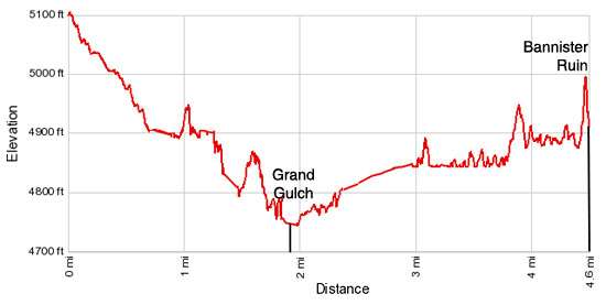
- Elevation: 5,100-ft. - 4,800-ft.
- Elevation Gain: -300-ft.
- Difficulty: easy-moderate
- Trail Highlights: See Trail Intro
- Basecamp(s): Grand Gulch / Blanding
- Region: Southeast Utah
This easy trail descends to scenic Grand Gulch and then travels up canyon to visit impressive Bannister House Ruins. Along the way the trail passes an old cowboy camp, an abandoned rincon, a small granary and small pictograph panels.
To Bannister House
The trailhead to Collins Canyon is located at the end of Collins Canyon Road, a dirt road off of UT-276 W, 48.3 miles from Blanding, Utah. (See driving directions below for more information.) Find the beginning of the trail at the south end of the parking area near a bulletin board and trail register. Rock cairns mark the trail as it winds down a slickrock slope and then descends along a boot beaten dirt path on easy grades. At this point the canyon is nothing more than a shallow draw.
At 0.3 miles the trail begins a descending traverse along an old cattle trail, cut into a sandstone ledge on the left (east) side of the canyon. Ahead a wood gate blocks livestock from wandering down the canyon. Please be sure to close the gate after passing through. Beyond the gate the trail drops down a slickrock slope to the canyon floor.
A tenth of a mile beyond the gate look for an overhang on the left sheltering a large alcove. Vegetation partially blocks the view. Use trails lead to the alcove where you will find the remains of an old cowboy camp. Artifacts from the camp including old tin cans, glass jars, plates, buckets, wire and other items are on displayed.
Past the cowboy camp watch for rock cairns marking the trail as it crosses over to the right (west/southwest) side of the canyon and then travels along a bench to detour around a pour-off. Over the course of the hike the trail will intermittently cross the wash and traverse boot beaten paths along its adjacent benches to cutoff meanders and avoid obstacles.
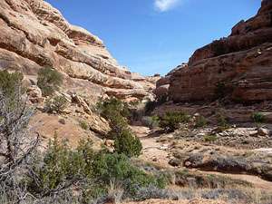
As you descend, the canyon’s scenic, multi-hued sandstone walls decorated with desert varnish grow in stature.
After hiking a little over 1.4 miles a small window/arch appears in a stubby sandstone fin jutting from the canyon’s north wall. The trail curves around the fin and then travels along a ledge on the north side of the canyon to circumvent a pour-off.
Soon the trail drops to the canyon floor and crosses to the south bench, passing a side canyon branching left (north/northeast). As you pass the side canyon the trail turns curves to the right (south).
Near the confluence of Collins Canyon and Grand Gulch flash floods have cut deep channels in the wash. Look for a steep trail ascending the bench to the right (south). Climb the bench and find a network of trails leading to the confluence and nearby campsites along with a path heading right (south) down Grand Gulch.
In the spring and after it rains you may find good pools of water around the confluence of Collins Canyon with Grand Gulch and along a few sections of Collins Canyon wash. Check on the current water conditions at the Kane Gulch Ranger Station before starting your trip. There are a number of campsites around the confluence and up and downstream from the confluence.
From the confluence of Collins Canyon with Grand Gulch, turn left to head up canyon toward Bannister Ruin. The trail briefly head northeast before turning southeast. Travel is relatively easy in this part of the canyon, with the route alternating between the packed-sand benches and the wash.
At 1.9 miles walk along the slickrock clad wash through a gap between two low sandstone ridges. To the south is an abandoned meander (rincon) where the stream in the wash once made a wide loop around the sandstone ridge to the south. At some point flood waters broke through the ridge, creating the channel where the stream now flows, cutting off the meander loop from the active stream bed.
Soon the canyon turns south and starts to travel down the first leg of a long gooseneck curve. At 2.3 miles scan the canyon’s west wall to see a small ruin tucked into a narrow alcove. The ruin is often in shadow and hard to see.
Continue following the boot beaten route that travels along benches to cutoff meanders and avoid long slogs through sandy sections of the wash. Stints along the benches offer nice view of the canyon’s sculpted sandstone walls decorated with desert varnish. Observant hikers may spot some small pictograph panels in an alcove high above the wash.
After walking 3.4 miles the trail curves to the south and then back to the northeast 0.4 miles later. As the trail heads northeast you may start to see water in the wash. This is a good sign that you are approaching Bannister Spring and Bannister RHouse uin.
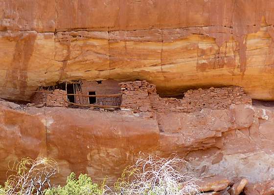
Bannister House Ruin, located on the canyon’s northwestern wall at 2.6 miles, is situated on two levels. The lower level consists of a double wall kiva with an intact roof and a large open activity area. The kiva’s roof is very fragile and in excellent condition. This kiva is rather unique in that it is above ground while most kivas are subsurface.
A chain was placed around the kiva and the adjacent midden (ancient trash pile) in the spring of 2003 to protect the fragile site. Please respect this closure. Do not lean against the kiva’s walls or attempt to climb into the kiva. The best view of the inside of the kiva can be obtained by peeking through the ventilator shaft (small opening in the front of the structure) or viewing it from the side.
The upper section of the ruin, now inaccessible, is composed of two or three jacal (waddle and daub) structures which are enclosed by an extensive masonry wall with a banister along the ledge. For the best views of the upper section of the ruin, cross the wash and look up through binoculars or the zoom lens of a camera.
The upper section of the ruin has not been entered since before 1985. Please note that it is illegal to use technical rock climbing equipment to access archaeological sites.
Seasonal Bannister Spring provides water for a few nice camping spots spread along the bench across from the ruins. The spring is located 0.25 miles down canyon from the ruins on the left (east) side of the canyon. Check with the Rangers at Kane Gulch about water availability at Bannister and other springs in Grand Gulch before setting out on your backpack.
Bannister House Ruin is a good turn around point for day hikers. After exploring the ruins and the nearby spring, simply retrace your steps to the trailhead.
If time and energy permits I recommend a side trip to the Narrows before climbing back up Collins Canyon. Just 0.3 miles down canyon (south) from the confluence of Grand Gulch and Collins Canyon is the Narrows and an abandoned meander (rincon) to the west where the stream once made a wide loop around a narrow sandstone ridge. At some point flood waters broke through the ridge, creating the narrow channel where the stream now flows, cutting off the meander loop from the active stream.
Pass through the narrows and look for a boot beaten path climbing a steep sandy slope to the right (west). The path leads to the south end of the rincon where you will find rock art and a small ruin along the canyon walls.
Day Hiking and Backpacking Permits for Cedar Mesa
Please note: Permits are required for hiking and backpacking in the canyons of Cedar Mesa, including Grand Gulch. Day use permits may be obtained at the Kane Gulch Ranger Station or at trailheads. During the spring and fall, overnight backpacking permits are only available at the Kane Gulch Ranger Station, and must be obtained on the morning of the trip. They may be reserved up to 90 days in advance by calling 435-587-1510. During other seasons, these permits may be obtained from the Monticello Field Office. See the BLM Grand Gulch website for more information.
Elevation Profile
Driving Directions
From Blanding, UT: Drive south on US 191 S for 4 miles and turn right (west) on UT-95 N. Follow UT-95 for 37.8 miles and turn left (southwest) on UT-276 W. Follow UT 276 for 6.6 miles and turn left (south/southwest) onto the Collins Canyon Road (UT-260) near mile maker 83. The road is signed for Collins Canyon. Follow the road for 6.5 miles to its end at the trailhead. Note the road gets progressively rougher as you near the trailhead. High clearance and 4WD vehicles are best. 2WD vehicles can make it if driven very carefully. Hikers with 2WD cars should check at the Kane Gulch Ranger station for current road conditions.
Trail Resources
Trail Intro / Trail Photo Gallery / Trail Map
Basecamp(s) Information:
Grand Gulch / Blanding
Region Information:
Southeast Utah
Other Hiking Regions in:
Utah