Hike Facts
- Distance: 2.5 miles (round trip)
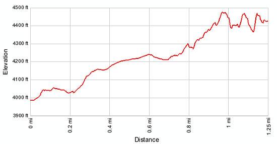
- Elevation: 3,990-ft. - 4,470-ft.
- Elevation Gain: 480-ft.
- Difficulty: easy-moderate
- Trail Highlights: See Trail Intro
- Basecamp(s): Moab
- Region: Southeast Utah
A short, relatively easy trail leads to stunning Corona Arch and its fascinating neighbor, Bowtie Arch, situated in a huge sandstone amphitheatre high above the northwest wall of Bootlegger Canyon.
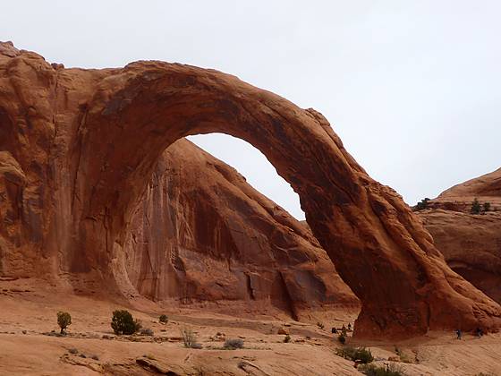
Corona Arch
The trailhead to Corona Arch is located to the left of a large bulletin board at the south end of the parking area (see driving directions). Follow the trail as it switchbacks up a rocky hillside with views of the Colorado River. At the top of the hill, just before the railroad track, is a trail registration box at 0.1 miles. The railroad track is a spur that runs from the Potash plant at the end of Utah 279/Potash Road, up Bootlegger Canyon and through a mile long tunnel to a point just west of US-191 near Moab. Past the tunnel the rail spur connects to the main rail line running north to Crescent Junction.
Cross the railroad track and continue along an old roadbed that curves to the right (east) around a low cliff. The trail now travels through a gap, swinging to the left as it ascends a rocky wash to the bench above. On the bench rock cairns mark the trail as it ascends on easy grades across slickrock and through desert scrub to a low sandy pass at 0.7 miles. Along the way views open to Pinto Arch, located high on the canyon wall to the north. The entire area is surrounded by scenic sandstone cliffs.
From the pass the trail gently descends toward the base of a large cliff along the northwest wall of Bootlegger Canyon. Follow the cairned slickrock route along the base of the cliff to the first set of safety cables, which facilitate the traverse along a moderately steep slope.
A short distance beyond the cables glorious views open to Bowtie and Corona Arch, situated along a massive sandstone wall on the north side of a huge amphitheatre. Continue along the base of the cliff to a set of safety railing at 0.9 miles. The railings and footholds chiseled in the rock aid the climb up a steep slickrock slope.
Beyond the cables is a 6-ft. metal ladder. The ladder eases the ascent a ledge to a slickrock bench. From this point it is an easy walk, following the cairned trail as it swings to the right (east) around the amphitheatre, traveling along the broad slickrock bench.
Pass beneath Bowtie Arch, a fascinating pothole arch, at 1.1 miles. Pothole arches are formed by chemical weathering when water collects in a natural depression and eventually cuts through the sandstone, creating a hole.
After admiring Bowtie, continue along the bench to impressive Corona Arch at 1.2 miles. This massive, stunning partially freestanding arch is 140-ft. high with a 105-ft. opening. Walk through the arch to the other side to truly appreciate the size of this beautiful span. On the east side of the arch enjoy nice views into Bootlegger canyon.
When you are done marveling at this amazing work of Mother Nature, retrace your steps back to the trailhead.
Elevation Profile
Driving Directions
From Moab: Drive north on US 191 N for 4 miles and turn left (southwest) on Utah 279 S / Potash Road. This turn is 1.3 miles north of the bridge on US 191 crossing the Colorado River. Follow Utah 279 S for 9.9 miles and turn right (northeast) into the signed Corona Arch parking area. The trailhead is located at the south end of the parking area to the left of the trailhead bulletin board.
Trail Resources
Trail Intro / Trail Photo Gallery / Trail Map
Basecamp(s) Information:
Moab
Region Information:
Southeast Utah
Other Hiking Regions in:
Utah