Details: Beards Wheatfield 
Distance: 6.8 - 8.2 miles (round trip)
Jedediah Smith Wilderness, Targhee National Forest, near Driggs in The Tetons
Hike Facts
- Distance: 6.8 - 8.2 miles (round trip)
- Elevation: 6,950-ft. - 9,550-ft.
- Elevation Gain: 2,600-ft.
- Difficulty: strenuous
- Trail Highlights: See Trail Intro
- Basecamp(s): Driggs / Jackson Hole
- Region: The Tetons
Great views of the Tetons and the peaks rimming the North and South Fork of Teton Canyon are the highlights of this off-the-beaten path trail climbing steeply up the north slopes of the North Fork to the ridge crest. Extend the hike by following a use trail along the panoramic ridge.
Beards Wheatfield Trail
This trail starts at the North Teton trailhead (see driving directions below). The path to Beards Wheatfield initially follows the Table Mountain Trail that climbs moderately-steep grades through aspen and conifers up the north side of the North Fork of Teton Canyon. Openings in the trees offer views of the 10,000-ft. peaks rimming the foot of the South Fork of Teton Canyon.
After 0.4 miles the grade eases and the trail travels through forest and intermittent meadows sprinkled with wildflowers, passing into the Jedediah Smith Wilderness at 0.5 miles. At 1.1 miles the forest gives way to a large meadow scattered with trees where the path resumes its climb on moderate to moderately-steep grades.
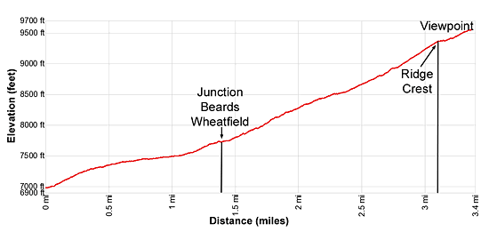
At 1.4 miles reach a signed junction. Here we bear left (west/northwest) on the Beards Wheatfield Trail. The trail to Table Mountain continues straight ahead up the North Fork of Teton Canyon. Interesting crags jut from the ridge above the trail.
The Beards Wheatfield trail now climbs steeply up the canyon’s north slopes, traveling through meadows sprinkled with wildflowers, aspens and conifers. The relentless climb is facilitated by switchbacks.
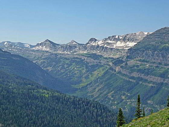
As the trail gains elevation enjoy fine views stretching southwest to Peak 10122 rising above the foot of the South Fork of Teton Canyon. Soon Mount Meek, the Wedge and the high ridge towering above the Teton Shelf join the scene to the south. The high peaks rimming the head of the North Fork of Teton Canyon dominate the view to the east. As the trail gains elevation the summit of Grand Teton appears to the southeast, soaring beyond the North Canyon’s headwall.
At 2.8 miles the path crests a minor ridge and then turns to the right (north), climbing very steep grades up meadows awash in wildflowers along the east side of the Miles Creek drainage. Nascent Miles Creek flows down a gully below the trail. Take a break from the relentless ascent to enjoy views of the high peaks rimming the South Fork and the summits of the Tetons rising above the head of the North Fork. Mount Owen, Grand Teton, Middle Teton and South Teton are now visible on the horizon.
At 3.1 miles the path crests the ridge rimming the north side of the North Fork and reaches a junction set amid a small grove of conifers. Views from the ridge crest now expand to include Fred’s Mountain to the northwest. Below the junction to the north is the large limestone bench beneath the east facing slopes of Fred’s Mountain. The peaks rimming the South Leigh Valley rise beyond the eastern edge of the bench while the high peaks of the Tetons grace the skyline beyond.
At the junction, the trail to Fred’s Mountain, which ends at the Grand Targhee Resort, branches left. To the right is an unmarked use trail. The continuation of the Beards Wheatfield trail crosses the ridge crest, drops down to the large limestone bench beneath Fred’s Mountain and then descends along a tributary stream to the South Fork of Leigh Creek Trail at 5.4 miles. From there is it another 2.9 miles to the South Leigh Trailhead. (This hike requires a long car shuttle.)
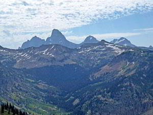
For even better views I recommend turning right (east) at the junction and following the unmarked use trail as it travels atop or just below the ridge crest. A fine overlook, set amid wildflowers, is located at 3.4 miles. Here vistas up the South Fork include Battleship Mountain, towering above the north side of the valley, and Buck Mountain and Static Peak rising beyond Alaska Basin. To the southeast, Mount Owen, Grand Teton, Middle Teton and South Teton, along with flat-topped Table Mountain fill the skyline beyond the head of the North Fork. To the northeast views extend to the peaks rising above the South Leigh, Granite and Green Lakes Valleys. The summits of the northern Tetons rise beyond the ridge crest separating Targhee National Forest and Grand Teton National Park
The hiker-made use trail along the ridge crest continues beyond the 3.4 mile point, traveling beneath peak 9691 before returning to the ridge crest. At 4.1 miles the trail fades above the South Leigh Lakes basin. Go as far as time, energy and the weather permit. When you are done taking in the views retrace your steps to the trailhead.
Elevation Profile
Driving Directions
From Driggs, ID: At the only traffic light in Driggs, located at the corner of Main Street (ID-33) and East Little Avenue, turn east onto East Little Avenue toward the Grand Targhee Ski area. Follow the road, which becomes Ski Hill Road and passes through Alta, WY, for 6.1 miles and turn right on Teton Canyon Road. (The road is signed for the Treasure Mountain/Teton Canyon campgrounds.) Drive 4.4 miles on Teton Canyon Road and park at the first trailhead parking area. The North Teton trailhead is located at the southeast end of the parking lot.
From Jackson, WY: Head south/southwest through Jackson on US 191 S / US 26 W. At the southwest end of town turn right on WY-22 W. (A large Albertson’s Supermarket is located on the southeast corner of the intersection.) Follow WY-22 W for 31.3 miles to Driggs, ID. The route will cross Teton Pass and entering Idaho, where the road becomes ID-33 and pass through Victor.
At the only traffic light in Driggs, located at the corner of Main Street (ID-33) and East Little Avenue, turn right (east) onto East Little Avenue toward the Grand Targhee Ski area. Follow the road, which becomes Ski Hill Road and passes through Alta, WY, for 6.1 miles and turn right on Teton Canyon Road. (The road is signed for the Treasure Mountain/Teton Canyon campgrounds.) Drive 4.4 miles on Teton Canyon Road and park at the first trailhead parking area. The North Teton trailhead is located at the southeast end of the parking lot.
Trail Resources
Trail Intro / Trail Photo Gallery / Trail Map
Basecamp(s) Information:
Driggs / Jackson Hole
Region Information:
The Tetons
Other Hiking Regions in:
Wyoming