Details: South Teton Trail to Mirror Lake in Alaska Basin 
Distance: 5.4 - 15.8 miles (round trip)
Jedediah Smith Wilderness, Targhee National Forest, near Driggs in The Tetons
By: Diane Greer
Hike Facts
- Distance: 5.4 - 15.8 miles (round trip)
- Elevation: 6,950-ft. - 9,570-ft.
- Elevation Gain: 2,620-ft.
- Difficulty: moderate-strenuous
- Trail Highlights: See Trail Intro
- Basecamp(s): Driggs / Jackson Hole
- Region: The Tetons
Wildflowers and great views of the peaks and cliffs rimming the South Fork Teton Canyon are the highlights of this long hike, best done as a backpack, climbing to beautiful Alaska Basin. Day hikers will find a scenic turn around point in the meadows below the basin.
South Teton to Alaska Basin
The South Teton Trail, popularly known as the Alaska Basin Trail, starts at the east side of the trailhead parking area. (See driving directions below). The path travels through forest along the east side of the South Fork Teton Canyon and soon enters the Jedediah Smith Wilderness Area.
The path now ascends on easy grades through forest and brushy meadows. Openings offer views of the South Fork of Teton Canyon Creek and the cliffs rising above the west side of the valley. Soon the cliffs rising above the Teton Shelf, a large bench high above the west side of the canyon, come into view. As you ascend the canyon these views continue to expand and improve.
At 1.5 miles the trail passes through a large meadow where The Wedge, Mt. Jedediah Smith and Mt. Meek join the scene to the southwest. During the height of the summer the meadow is adorn with beautiful displays of wildflowers set against a backdrop of the cliffs and peaks to the west/southwest.
At 2.6 miles the grade steepens as the trail ascends on moderate grades to the junction with the Devils Staircase Trail, branching right (west), at 2.7 miles. This trail climbs steeply up the canyon’s western slopes to the Teton Shelf, a scenic bench set beneath photogenic cliffs. This trail is used on the return leg of the Alaska Basin Backpack.
The junction with the Devil’s Staircase is a good turnaround point for day hikers looking for a shorter hiker. (Beyond this point the trail enters the trees and views are limited until the trail crosses to the north side of the canyon at 5.2 miles.)
Beyond the junction the trail enters the trees as it continues up the Canyon through viewless forest. A few small meadows along the way offer brief views up the canyon toward Alaska Basin and Hurricane Pass.
At 3.6 miles the grade abates as the path reaches the top of a bench. The respite is short lived as the trail resumes climbing on moderate to moderately steep grades at 3.75 miles. The path then crosses as tributary stream at 3.9 miles.
At 5.0 miles the grade again eases as the trail reaches a second bench. At 5.2 miles the trail crosses to the north side of the South Fork Teton Canyon Creek on a bridge and then quickly crosses two tributaries. Depending on the time of year and water levels, hikers may need to remove their boots and wade across the first tributary. The second tributary is bridged.
Beyond the crossings the ascent resumes on moderate to moderately steep grades. The landscape becomes more rugged, as the trail travels through an area of rock outcroppings. Rock cairns mark the path where it crosses exposed rock. Openings offer good views of the cliffs and peaks rising to the west.
At 5.9 miles the trail crosses the outlet stream for Sunset Lake. Beyond the crossing the path travels through clusters of trees and beautiful meadows set amid rock outcroppings. The meadows, filled with wildflowers during the height of the season, offer great views of the Wedge and the high cliffs rising to the west/southwest. The meadows are a good turn around point for day hikers.
At 6.5 miles the grade abates as the path crosses a stream. Past the crossing the grade moderates as the trail passes through an area of large boulders and rock outcroppings. Views soon open to a waterfall that marks the crossing of a stream emanating from Alaska Basin at 6.7 miles.
At 6.9 miles the trail curves to the left (east/northeast) and ascends on moderate grades through a rocky landscape, crossing a few streams along the way. Cascades along streams spill down ledges near the trail.
At 7.5 miles the trail crests the Alaska Basin bench. Here gorgeous views open to a large meadow set against a backdrop Buck Mountain and Peak 11094 rising to the east/southeast. A short distance beyond is the junction with the Teton Crest Trail. Turning left (north) on the Teton Crest Trail leads to Sunset Lake and Hurricane Pass. To the right the combined South Teton and Teton Crest trails head toward Mount Meek Pass.
This is a beautiful spot to stop and catch your breath. To the west/southwest are stunning views of the peaks and ridges rimming the west side of the South Fork Teton Canyon. Mount Meek marks the southwest end of the ridge. Buck Mountain and Peak 11094 dominate the views to the east. A small tarn lies amid the meadows scattered with wildflowers.
Turn right on the combined South Teton/Teton Crest trail toward Mount Meek Pass. At 7.6 miles reach a second junction. To camp in the Basin Lakes area of Alaska Basin bear left (southeast) on the continuation of the South Teton Trail toward Mirror Lake and Buck Mountain Pass. The Teton Crest Trail branches right (southwest) toward Mount Meek and Fox Creek Passes.
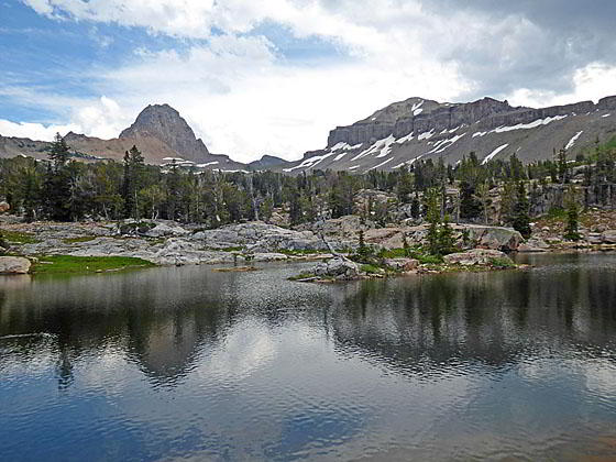
The South Teton trail now winds between some of the smaller lakes and tarns to reach Mirror Lake, the largest of the Basin Lakes, at 7.9 miles. There are many great camping sites in the basin. I strongly recommend doing some serious exploring to find the perfect spot that is away from other campers and features fine views of the surrounding peaks.
Strong, well acclimated day hikers can create a very scenic 16.6 miles loop hike by combining the Devils Staircase, Teton Crest and South Teton trails. From the junction with South Teton and Teton Crest trail at 7.6 miles, it is 2.0 miles to the junction with the Devil’s Staircase Trail and then 7.0 miles along the Staircase Trail to the South Teton trail and the trailhead.
Mere mortals should do the loop as an overnight backpack with a night spent in Alaska Basin. Better yet, camp a few additional nights in Alaska Basin and visit Death Canyon Shelf, Hurricane Pass and Buck Mountain Pass on day hikes. See the Alaska Basin Backpack for more information.
Elevation Profile

Driving Directions
From Driggs, ID: At the only traffic light in Driggs, located at the corner of Main Street (ID-33) and East Little Avenue, turn east onto East Little Avenue toward the Grand Targhee Ski area. Follow the road, which becomes Ski Hill Road and passes through Alta, WY, for 6.1 miles and then turn right on Teton Canyon Road. (The good gravel road is signed for the Treasure Mountain/Teton Canyon campgrounds.) Drive 4.4 miles on Teton Canyon Road to the trailhead parking area for the North Teton trail. Continue through the parking area and drive 0.2 miles to the end of the road and the South Teton trailhead. Park here.
From Jackson, WY: Head south/southwest through Jackson on US 191 S / US 26 W. At the southwest end of town turn right on WY-22 W. (A large Albertson’s Supermarket is located on the southeast corner of the intersection.) Follow WY-22 W for 31.3 miles to Driggs, ID. The route will cross Teton Pass and entering Idaho, where the road becomes ID-33 and pass through Victor.
At the only traffic light in Driggs, located at the corner of Main Street (ID-33) and East Little Avenue, turn right (east) onto East Little Avenue toward the Grand Targhee Ski area. Follow the road, which becomes Ski Hill Road and passes through Alta, WY, for 6.1 miles and turn right on Teton Canyon Road. (The good gravel road is signed for the Treasure Mountain/Teton Canyon campgrounds.) Drive 4.4 miles on Teton Canyon Road to the trailhead parking area for the North Teton trail. Continue through the parking area and drive 0.2 miles to the end of the road and the South Teton trailhead. Park here.
Trail Resources
Trail Intro / Trail Photo Gallery / Trail Map
Basecamp(s) Information:
Driggs / Jackson Hole
Region Information:
The Tetons
Other Hiking Regions in:
Wyoming