Details: Table Mountain 
Distance: 13.0 miles (round trip)
Jedidiah Smith Wilderness, Targhee National Forest, near Driggs in The Tetons
Hike Facts
- Distance: 13.0 miles (round trip)
- Elevation: 6,950-ft. - 11,106-ft.
- Elevation Gain: 4,156-ft.
- Difficulty: strenuous
- Trail Highlights: See Trail Intro
- Basecamp(s): Driggs / Jackson Hole
- Region: The Tetons
My favorite trail on the west side of the Tetons features jaw-dropping views of Grand, Middle and South Tetons towering above Cascade Canyon. The long, strenuous trail ascends Table Mountain where views extend from Mount Moran in the north to Mount Bannon in the south.
Trailhead to Table Mountain
From the trailhead at the base of the North Fork of Teton Canyon (see driving directions below), the trail to Table Mountain wastes no time gaining elevation as it starts climbing on moderately-steep grades through aspen up the north side of the valley. Openings in the trees offer views of the 10,000-ft. peaks rimming the South Fork of Teton Canyon.
After 0.4 miles the grade eases and the trail travels through forest and intermittent meadows sprinkled with wildflowers. At 1.1 miles the forest gives way to large meadow scattered with trees. Here the path resumes climbing on moderate to moderately-steep grades.
At 1.4 miles pass the junction with the Beards Wheatfield Trail branching left. We continue straight ahead. Above the trail to the interesting crags jut from the ridge.
The grade briefly eases at 1.6 miles as the trail curves to the right (east), echoing the contours of the canyon. Soon the climb resumes and we pass a blocked trail on the left at 2.0 miles. This is an old trail that has been rerouted to remove two stream crossing that were difficult early in the season.
At 2.2 miles the trail draws near the North Fork Creek, offering the first good views of the pretty stream. Beyond the viewpoint the trail crosses rock outcroppings and weaves through rocky meadows scattered with trees as it ascends the canyon to the north of the creek. At 2.4 miles the trail passes through an avalanche area scattered with down trees. Ahead views open to Peak 10,650 at the head of the canyon. Past the avalanche debris the trail starts curving to the left (southeast) as it continues the moderately-steep climb up the valley.
Cross to the south side of North Fork Creek at 2.8 miles. The remains of an old bridge will help keep your feet dry after the water has gone down. Otherwise, you may need to take off your shoes and wade. (Hopefully they will replace the bridge.) Beyond the crossing the trail briefly steepens, climbing over rock slabs along a waterfall. Soon the trail reenters the trees.
A large meadow at 3.2 miles offers our first views of Table Mountain and the long ridge leading to the summit. In the meadows we cross a broad, shallow tributary of North Fork Creek. Use the logs and rocks in the streambed to keep your feet dry. Early in the season you will need to wade the crossing.
The path now ascends through clusters of trees and meadows. Peak 10,650 towers above the valley to the east.
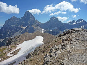
Reach a beautiful basin clad in meadows and scattered trees at 3.6 miles. The basin is surrounded by a cirque anchored by Table Mountain to the southeast. To the south is the long ridge leading to the summit. The basin’s meadows are filled with wildflowers in season.
In the basin the trail turns to the right (west) at 3.75 miles and climbs steep switchback up the cirque’s east facing headwall. Along the way the path crosses a small stream. As the trail ascends enjoy ever improving views of Table Mountain and the peaks rimming the north side of the valley. In season the meadows are awash in a glorious display of wildflowers. Near to top of the climb views open to the summits of Grand Teton and Mount Owen rising beyond Table Mountain.
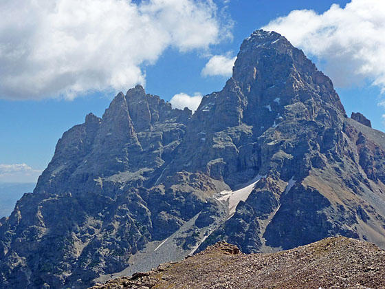
At 4.6 miles the trail crests the ridge and the grade abates. We now have a clear view of the path to our destination along Table Mountain’s long west ridge. Teewinot Mountain, Mount Owen and Grand Teton tower beyond the north side of Table Mountain while South Teton rises to the south. To the northeast are terrific views of the peaks rimming the north side of the North Fork valley.
The level trail now curves south and then southeast along the ridgetop. Views open southeast to the Teton Shelf, Mount Meeks and the high peaks rimming Death Canyon along with Battleship Mountain. To the north are great views of the North Fork Valley. Soon Middle Teton emerges to the right of Table Mountain’s summit. As your progress the views continue to expand and improve.
At 5.0 miles pass a junction with a trail branching right. This the extremely steep Face Trail that loses over 2,900-ft. in 2.6 miles as it heads back to the trailhead. This trail is not recommended unless you are an extremely well-conditioned and sure-footed hiker comfortable on very steep rocky slopes.
At 5.1 miles the trail resumes its climbs on moderately steep grades. At this point you still have 1,150-ft. to climb over 1.25 miles. Take a look at the weather. Turn around if the weather is taking a turn for the worse. You are now completely exposed with no cover in the event of a thunderstorm.
At 5.4 miles we reach the broad ridge leading to the summit. The trail now climbs at a steady pace up the ridge. Ahead we see the tip of Grand Teton and Middle Teton rising on either side of Table Mountain. The views continue to evolve as you climb higher. At 5.7 miles views open northeast to the summit of Mount Moran, Mount Woodring and the peaks rimming the North Fork of Cascade Canyon.
At 5.75 miles the trail reaches a boulder field atop the ridge. Large cairns mark the path through the rocks. The rock field soon ends and we continue the climb through rocky meadows.
The grade steepens as you near the base of the summit block at 6.25 miles. The path now climbs up very steep talus slopes. In places the trail is braided. Take the track with the best footing. Near the top of the climb the trail ascends switchbacks up rock ledges. To the south are views of Hurricane Pass.
Crest the summit block of Table Mountain (11,106-ft.) at 6.5 miles. Here a stunning quintet of high peaks spring into view. Dead ahead are breathtaking views of Teewinot Mountain, Mount Owen, Grand Teton, Middle Teton and South Teton. The peaks seem close enough to touch. Amazing vistas of the peaks lining Cascade Valley and Paintbrush Divide along with Mount Moran and Thor Peak fill the skyline to the northeast.
Head southwest across the summit block and find a high perch along the eastern edge to enjoy more stunning views of the west face of Grand Teton and its neighbors. Below the summit is the upper reaches of the South Fork of Cascade Canyon. From the summit of Table Mountain you can follow the Continental Divide south to Hurricane Pass. Mount Wister and Buck Mountain dominate the views to the southeast. Mount Meeks and the Peaks rimming Death Canyon rise in the distance to the south. To the southwest are the summits towering above the Teton Shelf.
It is truly hard to pull yourself away from the views. But eventually you need to return to the trailhead. Enjoy the great views as you retrace you steps down the ridge and then descend to the basin. From here it’s a nice walk through meadows and forest back to the trailhead.
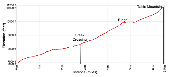
Elevation Profile
Driving Directions
From Driggs, ID: At the only traffic light in Driggs, located at the corner of Main Street (ID-33) and East Little Avenue, turn east onto East Little Avenue toward the Grand Targhee Ski area. Follow the road, which becomes Ski Hill Road and passes through Alta, WY, for 6.1 miles and turn right on Teton Canyon Road. (The road is signed for the Treasure Mountain/Teton Canyon campgrounds.) Drive 4.4 miles on Teton Canyon Road and park at the first trailhead parking area. The North Teton trailhead is located at the southeast end of the parking lot.
From Jackson, WY: Head south/southwest through Jackson on US 191 S / US 26 W. At the southwest end of town turn right on WY-22 W. (A large Albertson’s Supermarket is located on the southeast corner of the intersection.) Follow WY-22 W for 31.3 miles to Driggs, ID. The route will cross Teton Pass and entering Idaho, where the road becomes ID-33 and pass through Victor.
At the only traffic light in Driggs, located at the corner of Main Street (ID-33) and East Little Avenue, turn east onto East Little Avenue toward the Grand Targhee Ski area. Follow the road, which becomes Ski Hill Road and passes through Alta, WY, for 6.1 miles and turn right on Teton Canyon Road. (The road is signed for the Treasure Mountain/Teton Canyon campgrounds.) Drive 4.4 miles on Teton Canyon Road and park at the first trailhead parking area. The North Teton trailhead is located at the southeast end of the parking lot.
Trail Resources
Trail Intro / Trail Photo Gallery / Trail Map
Basecamp(s) Information:
Driggs / Jackson Hole
Region Information:
The Tetons
Other Hiking Regions in:
Wyoming