Details: Garnet Canyon 
Distance: 8.2 - 9.4 miles (round trip)
Grand Teton National Park, near Grand Teton NP in The Tetons
Hike Facts
- Distance: 8.2 - 9.4 miles (round trip)
- Elevation: 6,720-ft. - 9,280-ft.
- Elevation Gain: 2,270-ft. - 2,560-ft.
- Difficulty: moderate-strenuous
- Trail Highlights: See Trail Intro
- Basecamp(s): Grand Teton NP / Jackson Hole
- Region: The Tetons
Stunning views of Middle Teton, Nez Perce and Jackson Hole are the highlights of this scenic hike up Garnet Canyon. This trail, part of the popular climbing route to Grand, Middle and South Tetons, is not as heavily trafficked as nearby Amphitheater Lakes.
Trailhead to Garnet Canyon
Distance from Trailhead: 8.2 miles (round trip)
Ending/Highest Elevation: 8,990-ft.
Elevation Gain: 2,270-ft.
The trail to Amphitheater Lake leaves from the west end of the Lupine Meadow Trailhead (see driving directions below). Follow the trail as it heads south through trees on easy grades, crossing a bridge over a stream in Glacier Gulch at 0.6 miles. Beyond the crossing the grades steepens as the path travels through forest and brushy meadows on moderate grades. Openings offer brief glimpses of Teewinot Mountain (12,235-ft.) and Grand Teton (13,770-ft.)
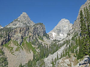
After a mile the trail curves to the west. Soon good views briefly open to Teewinot Mountain and Grand Teton towering overhead. The path now climbs a low ridge separating Glacier Gulch, to the north, from Burned Wagon Gulch, to the south. As you ascend views open to Nez Perce (11,901-ft.) rising above the south side of Garnet Canyon. Teewinot is seen through the trees to the northwest.
At 1.7 miles pass the junction with the Valley Trail, branching left and dropping down to Bradley and Taggart Lakes. Past the junction the trail climbs moderately-steep switchback up the broad ridge between Glacier Gulch and Garnet Canyon. The brushy meadows with scattered trees offer good views of Jackson Hole to the south. Soon views open to Bradley and Taggart Lake, nestled in forested glacial bowls, to the south.
The stiff climb up the well-constructed trail offers little cover, making for a hot climb during the summer. Get an early start to ascend the switchbacks during the cool of the morning.
At 3.0 miles turn left (south) at the junction with the Garnet Canyon trail. Here we leave most of the hikers behind. You will see climbers using the trail to reach popular climbing routes of Grand Teton, Middle Teton and South Teton.
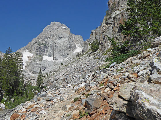
The Garnet Canyon trail now heads south/southwest on easy grades, curving left (west) into Garnet Canyon at 3.4 miles. After passing through a cluster of trees dramatic views open to Nez Perce rising along the south side of the canyon. Middle Teton (12,804-ft.), with its signature 800-ft. long vertical dike, towers above the head of the canyon.
At 3.6 miles the rocky trail starts ascending on moderate to moderately-steep grades, traveling through a series of talus slopes beneath Disappointment Peak. Rugged crags jut from the canyon walls above the trail. Ahead are ever improving views of majestic Middle Teton.
At 4.1 miles reach a junction with a sign pointing left toward platform campsites and straight ahead toward the Lower Saddle. Straight ahead a field of massive boulders fills the canyon floor. This is the official end of a Garnet Canyon trail.
Conquering the boulder field is beyond the ability of many hikers. Instead of risking injury, find a comfortable rock and enjoy the stunning views of Middle Teton and the rugged canyon. When you are done taking in the views, retrace your steps to the trailhead.
The Boulder Field to the Meadows
Distance from Trailhead: 9.4 miles (round trip)
Ending/Highest Elevation: 9,280-ft.
Elevation Gain: 2,560-ft.
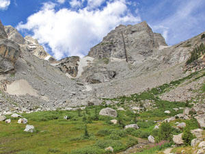
There is no marked route through the boulder field, which is about 350-ft. long. Instead hikers must find their own route by scrambling through a labyrinth of huge boulders. This is a very difficult section that will have your using your hands as you chart a course through the maze. At the end of the boulder field the trail travels along talus slopes to “The Meadows”, a camping zone for climber. Here emerald green meadows filled with flowers in season lie at the base of a stunning cirque formed by Nez Perece, Couldveil Dome, South Teton (12,514-ft), Middle Teton, Grand Teton and Disappointment Peak. Pretty Spaulding Falls tumbles down talus slopes to the north.
At 4.5 miles the trail splits, the path to the right climbs steep switchbacks keeping to the right (east) of the falls toward the climbing routes. We continue straight ahead on the trail the crosses the creek and then ends in a massive talus field. Here is a great place to rest and enjoy the breathtaking views of the Tetons before retracing your steps to the trailhead.
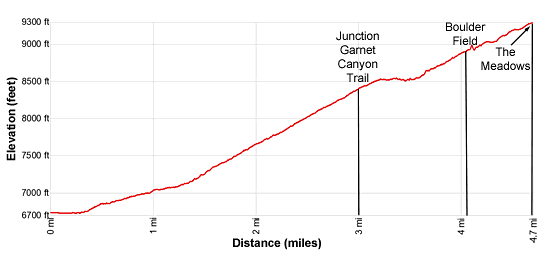
Elevation Profile
Driving Directions
From Jackson, WY: From the main square at North Cache and Broadway, head north on North Cache Street (US-191 N / US-26 E) for 12.4 miles to Moose Junction and turn left on Teton Park Road. Follow Teton Park Road for 1.0 mile, past the main visitor center, to the entrance/fee station. Continue beyond the entry station for 6.2 miles and turn left on the road signed for Lupine Meadows. Follow the road for 1.2 miles to the large parking area at the end of the road. This is a very popular area and the parking lot fills early. Additional parking is available 0.4 miles back down the road.
From Teton Village, WY: Head out of the village and turn left on the Moose-Wilson Road. Follow the road for 1.1 miles to the park entrance/fee station. Beyond the fee station drive 6.9 miles on the narrow, winding road and turn left on Teton Park Road. Follow Teton Park Road for 0.4 miles to the park entrance/fee station. Continue beyond the entry station for 6.2 miles and turn left on the road signed for Lupine Meadows. Follow the road for 1.2 miles to the large parking area at the end of the road. This is a very popular area and the parking lot fills early. Additional parking is available 0.4 miles back down the road.
Trail Resources
Trail Intro / Trail Photo Gallery / Trail Map
Basecamp(s) Information:
Grand Teton NP / Jackson Hole
Region Information:
The Tetons
Other Hiking Regions in:
Wyoming