Details: Lake Solitude 
Distance: 14.6 miles (round trip)
Grand Teton National Park, near Grand Teton NP in The Tetons
By: Diane Greer
Hike Facts
- Distance: 14.6 miles (round trip)
- Elevation: 6,800-ft. - 9,055-ft.
- Elevation Gain: 2,255-ft.
- Difficulty: strenuous
- Trail Highlights: See Trail Intro
- Basecamp(s): Grand Teton NP / Jackson Hole
- Region: The Tetons

My favorite day hike in the Tetons features stunning views of Teewinot Mountain, Mount Owen and Grand Teton, passes pretty waterfalls, travels through alpine meadows awash in wildflower and ends at beautiful Lake Solitude, nestled in a rugged granite cirque
Trailhead to Hidden Falls and Inspiration Point
Distance from Trailhead: 1.8 miles (round trip)
Ending/Highest Elevation: 7,220-ft.
Elevation Gain: 420-ft.
There are two ways to start the hike to Lake Solitude. The first option starts near the boat dock on the southeast side of Jenny Lake and then travels around the south and west sides of the lake, reaching a junction with the Cascade Canyon trail at 2.1 miles. Total round-trip distance to Lake Solitude is 18.4 miles, out of the reach of most day hikers.
I recommend the second option, taking the shuttle boat across Jenny Lake to the boat dock at the mouth of Cascade Canyon on the west side of the lake. The shuttle boat, which runs every 10-15 minutes, reduces the hike distance to 14.4 miles (round-trip). This is still a long day but doable by well-conditioned hikers.
This hiking description assumes you start the hike at the boat dock on the west side of Jenny Lake. The boat ride is quite scenic, featuring great views of Nez Perce (11,901-ft.), Teewinot Peak and Cascade Canyon. Check the current boat schedule before setting out. Departure times are less convenient in May, early June and September.
From the boat dock the trail initially heads south, ascending on easy grades through spruce-fir forest. Soon the trail curves to the west, passes a junction (stay left) and then crosses a wood bridge over Cascade Creek at 0.2 miles. Beyond the bridge the trail climbs on moderate grades, passing junctions with the Jenny Lake trail. Stay on the Cascade Canyon trail toward Hidden Falls, Inspiration Point and Cascade Canyon.
At 0.5 miles reach the junction with the spur trail to Hidden Falls, branching left. Take a detour and visit the viewing area at the base of the impressive falls, dropping over 200-ft. down a series of tiers. Return to the main trail after seeing the falls.
Past the Hidden Falls junction the trail quickly crosses a wood bridge to the north side of Cascade Creek and then climbs rugged switchbacks up a granite knoll to Inspiration Point (7,220-ft.), at 0.9 miles from the boat dock. Here vistas extend across Jenny Lake to the Gros Ventre Mountains and the Gros Ventre Slide, a massive 1925 landslide. Turn around for views of Storm Point and Symmetry Spire to the west. Teewinot Mountain towers over Cascade Canyon to the southwest. As you stand at the viewpoint imagine the massive glacier that flowed out of Cascade Canyon. When the glacier receded it deposited the moraines (low ridges) that dam Jenny Lake. (Note: Views from the overlook are best in the afternoon.)
Inspiration Point to the Forks
Distance from Trailhead: 9.4 miles (round trip)
Ending/Highest Elevation: 7,875-ft.
Elevation Gain: 1,075-ft.
Beyond Inspiration Point the path curves to the west, ascending on easy grades through trees and lush vegetation along the north side of Cascade Canyon. The rugged crags of Cube Point rise to the north of the trail. Over the next 3.7 miles the trail will gain about 650-ft. on its way to the Forks of Cascade Canyon.
At 1.3 miles pass the junction with the horse trail dropping down to the lake. A short distance beyond the trail reaches an overlook with nice views of the creek spilling over large rock slabs.
At 1.6 miles the trail starts a traverse through a series of rock slide beneath Storm Point. Soon views open to jagged profiles of Teewinot Mountain and Mount Owen (12,928-ft.) towering above the south side of the canyon. This trio of the highest peaks in the park is referred to as the Cathedral group because the jagged summits resemble church spires. Yosemite Peak, Peak 10650 and The Wigwams rise along the head of the valley. Beneath the trail Cascade Creek meanders down the willow choked valley floor. Beaver dams are prevalent along sections of the creek.
As you hike up Cascade Canyon, keep an eye out for moose, which are often seen grazing in the dense willows along the canyon bottom.
At 2.3 miles the trail travels along another rock slide. Here the creek broadens into a small pond, known locals as Perch’s Pond. Here views again open to Teewinot and Mount Owen along with the summits at the head of the canyon. Early in the morning the peaks of the canyon are reflected in the pond’s still waters. This is a lovely little spot and a good turnaround point for people seeking a short hike up the canyon.
As you continue up the canyon the trees start to thin and small meadows appear, offering up views of the canyon’s high peaks. At 2.8 miles lovely views open to a waterfall spilling down the rugged slope between Teewinot and Mount Owen. A short distance beyond a traverse through another rock slide serves up great views of the rugged crags of the Rock of Ages looming above the north side of the trail.
At 3.4- and 3.7-miles the path travels along avalanche chutes beneath the steep slope of the Jaw and Buckingham Palace, summits along the ridge rimming the north side of the valley. The open slopes offer views of the rugged crags. Across the valley to the south a waterfall is soon seen cascading down a rugged gorge below Valhallla Canyon, a hanging valley extending from the northwest flanks of Mount Owen and Grand Teton (13,770-ft.). A short distance beyond the summit of Grand Teton is seen rising beyond Mount Owen.
At 4.0 mile the trail reenters the trees and a half mile beyond crosses a wood bridge over the rushing waters of Cascade Creek. The bridge is located just above the confluence of Cascade Creek with the South Fork of Cascade Creek. Beyond the bridge the trail climbs on moderate grades, reaching the Forks of Cascade Canyon at 4.7 miles. (Note: Our mileage includes the side trip to Hidden Falls.)
The Forks, a forested junction where the North and South Fork of Cascade Canyon meet, is another good turnaround spot for parties who don’t want to walk all the way to Lake Solitude day. During the middle of the day the forks is a busy place, with both day hikers and backpackers using nearby logs to rest.
Here the South Fork of Cascade Canyon trail, to the left (south/southwest), climbs to Hurricane Pass (10,400-ft.) gaining 2,525-ft. in 5.1 miles. To the right (northwest) is Lake Solitude (9,035-ft.) and Paintbrush Divide (10,720-ft.).
Note: If time and energy permit, I strongly recommend continuing beyond the Forks for 0.9 miles to the second bridge where you have terrific views of the Cathedral Group -- Teewinot Mountain, Mount Owen and Grand Teton.
The Forks to Lake Solitude
Distance from Trailhead: 14.6 miles (round trip)
Ending/Highest Elevation: 9,055-ft.
Elevation Gain: 2,255-ft.
Turn right at the forks to continue to Lake Solitude. The path now climbs through forest on moderate grades along the west side of Cascade Creek. At 5.0 miles the trail crosses a wood bridge to the east side of the canyon. As you ascend the trees give way to open meadows revealing an interesting granite knob rising to the west. A waterfall tumbles down the brushy slopes to the south of the knob.
As you proceed up valley enjoy ever improving views. Ahead is a classic glacial valley, rimmed by rugged granite peaks. In season the meadows support a variety of pretty wildflowers. Turn around to the south for breathtaking views of Teewinot Mountain, Mount Owen and Grand Teton towering above the foot of the valley.
At 5.6 miles the trail crosses back to the west side of Cascade Canyon on a small wood bridge. Beyond the bridge the trail angles away from the creek, ascending on moderate to moderately-steep grades along the west side of the valley. At 5.7 miles pass a sign marking the start of the North Fork of the Cascade camping zone. Wooden stakes mark the various campsites.
As you climb the trail passes through small copses of trees, traverses rock falls and boulder fields and climbs up rock outcroppings. Above the trail to the west interesting rock formations grace the ridges extending from the Wigwam Peaks. To the south the Cathedral Group now creates a stunning backdrop for the scenic valley.
As you near the head of the valley at 6.7 miles views open to a pretty waterfall spilling down the rugged slopes above the trail. The falls is fed by Mica Lake, nestled in a hanging valley along the western wall. Ahead are views of the ridge and peaks rimming the head of the valley.
At 6.8 miles the trail crosses the steam below the falls. The well-watered area around the steam supports a profusion of wildflowers. A short distance beyond a small sign marks the end of the camping zone (6.9 miles).
At 7.0 miles the path crosses a wood bridge over Lake Solitude’s outlet stream gushing down a steep, rocky stream bed. The grade abates at 7.2 miles as the trail crests the scenic bench, ringed by a cirque of granite peaks, cradling Lake Solitude (9,035-ft.).
At 7.25 miles reach a junction with the trail to Paintbrush Divide branching right. We turn left on a spur trail that reaches Lake Solitude’s eastern shore at 7.3 miles. The stunning lake is surrounded on three side by rocky meadows sprinkled with wildflowers. Peak 10686 towers above the lake to the west while sheer cliffs rim the valley wall to the northwest. To the east the trail to Painbrush Divide diagonals up talus slopes towards the pass. Teewinot, Owen and the Grand Teton dominate the view to the south.
Retrace your steps to the boat dock when you are done lounging around the lake. Watch the time. You don’t want to miss the last boat and have to walk an additional 2.0 miles back to your car.
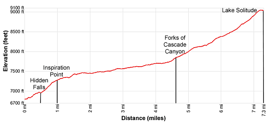
Elevation Profile
Driving Directions
From Jackson, WY: From the main square at North Cache and Broadway in Jackson Hole, WY, head north on North Cache Street (US-191 N / US-26 E) for 12.4 miles to Moose Junction and turn left on Teton Park Road. Follow Teton Park Road for 1.0 mile, past the main visitor center, to the entrance/fee station. Continue beyond the entry station for 6.9 miles and turn left on the road signed for Jenny Lake. Drive 0.4 miles to the parking lot at the end of the road. This is the closest parking area to the Jenny Lake Shuttle Boat dock. See the Jenny Lake Shuttle Boat site for more information about the service.
From Teton Village, WY: Head out of the village and turn left on the Moose-Wilson Road. Follow the road for 1.1 miles to the park entrance/fee station. Beyond the fee station drive 6.9 miles on the narrow, winding road and turn left on Teton Park Road. Follow Teton Park Road for 0.4 miles to the park entrance/fee station. Continue beyond the entry station for 6.9 miles and turn left on the road signed for Jenny Lake. Drive 0.4 miles to the parking lot at the end of the road. This is the closest parking area to the Boat Dock.See the Jenny Lake Shuttle Boat site for more information about the service. Note: A portion of the Moose-Wilson road is unpaved and very rough.
Trail Resources
Trail Intro / Trail Photo Gallery / Trail Map
Basecamp(s) Information:
Grand Teton NP / Jackson Hole
Region Information:
The Tetons
Other Hiking Regions in:
Wyoming