Details: String, Leigh, Bearpaw and Trapper Lakes 
Distance: 3.2 - 10.0 miles (round trip)
Grand Teton National Forest, near Grand Teton NP in The Tetons
Hike Facts
- Distance: 3.2 - 10.0 miles (round trip)
- Elevation: 6,870-ft. - 6,930-ft.
- Elevation Gain: 280-ft.
- Difficulty: easy
- Trail Highlights: See Trail Intro
- Basecamp(s): Grand Teton NP / Jackson Hole
- Region: The Tetons
Travel along a series of photogenic lakes with gorgeous views of the Teton Range stretching from Teewinot Mountain to Mount Moran. This is a great area for families or anyone looking for an easy, relaxed outing with great views.
Trailhead to the Lakes
Distance for Various Destinations:
- String Lake to foot of Leigh Lake: 3.2 miles (RT)
- Sting Lake Loop: 3.6 miles (loop)
- String Lake to Last Viewpoint Leigh Lake: 7.0 miles(RT)
- String Lake to Bearpaw and Trapper Lakes: 10.0 miles (RT)
Note: This description assumes you start at the beginning of the String Lake trail, at the southeast corner of Sting Lake. The parking area at the trailhead is very small. A larger parking area is located at the end of the String Lake Road. If starting from here, reduce the out-and-back hiking distances in the description by 0.4 mile (one-way) or 0.8 miles (round trip).
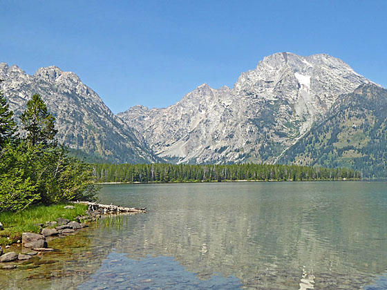
Beautiful String Lake, the first lake along the chain, is a favorite destination in Grand Teton National Park. The shallow lake is warm enough to encourage swimming, a fun place to canoe/kayak and a great place for a picnic. Mount Saint John (11,430-ft.) and Rockchuck Mountain (11,144-ft.) tower above the lake to the west. To the southwest are fine views of the Cathedral Group; Teewinot Mountain (12,235-ft.), Mount Owen (12,927-ft.) and the Grand Teton (13,770-ft.). Mount Moran (13,605-ft.) rises to the northwest.
From the southeast end of String Lake the String Lake Trail heads northwest (toward Leigh Lake) along the east side of the lake. The first section of the trail is paved. Viewpoints and numerous access points along the shore will slow your progress. The beginning of the hike features stunning views of the Cathedral Group, composed of the largest peaks in the park, along with Mount Saint John and Rockchuck Mountain. Reeds grow along the lakeshore and fish dart about the clear, shallow water.
At 0.3 miles the trail curves to the north as it crosses a wood bridge across a small bay. Here the lake narrows. As you travel along the lakeshore the views slowly evolves with Mount Saint John and Rockchuck Mountain dominating the view across the lake. Teewinot and Symmetry Peak rise to the southwest.
Soon the path reaches the junction with the Leigh Lake trail at 0.5 miles. To your right, a 0.1 mile walkway leads to the upper parking area. We continue straight ahead along the Leigh Lake trail that swings to the northeast and briefly leaves the lakeshore, traveling through forest.
At 0.7 miles we again reach the lakeshore where fine views open to Mount Moran rising to the northwest. Early in the morning the peak is perfectly mirrored in the lake’s still waters. The path now winds along the lakeshore, passing a trail branching right at 0.9 miles.
At 1.3 miles reach the junction with the String Lake Loop trail branching left (northwest) toward Paintbrush Divide. (Information on the Loop Trail is at the end of this description.) Stay on the manl trail toward Leigh and Bearpaw Lakes. A short distance beyond the trail splits with the trail to the left (west) heading toward the Leigh Lake Portage. The Portage Trail offers easy access to the south end of the lake shore. We bear right on the Leigh Lake Trail.
The path now curves east/northeast and climbs over a few low knolls at the south end of Leigh Lake. The lake, the third largest in the park, measures over 2.3 miles wide and almost 2.8 miles long. Access to the shore is limited to a few spots where spur trails or openings serve up a variety of views of the Teton Range.
Reach the first access point at 1.6 miles. Here Mount Moran towers above the northwest end of the lake. The rugged massif in the distance to the north is Eagle’s Rest (11,258-ft), rising along the west side of Jackson Lake. A small rocky, photogenic island with one evergreen lies a short distance off the shore.
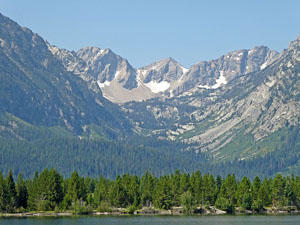
At 2.0 miles drop down to the shore to get your first views up Leigh Canyon where Thor Peak (12,028-ft.) rises to the west of Mount Moran. Soon views open to Mount Woodring (11,590-ft.), guarding the south end of Leigh Canyon.
Drop down to the lakeshore at 2.6 miles for views up Paintbrush Canyon, the canyon to the south of Mount Woodring. Here we see Peak 11,270-ft. rising above the head of the canyon (Paintbrush Divide). Soon we pass two group sites along the trail where there are more great views across the lake.
Enjoy stunning views up Paintbrush Canyon at 3.25 miles. Here we can see a trio of peaks, Peak 11270-ft., McClintock Peak and Buckinham Palace at the head of the divide. Rockchuck Peak rises to the south of the canyon entrance. Nearer-at-hand is Mystic Isle lying just about a quarter mile off the shore. To the east of the trail are the downed trees from a wildfire.
At 3.5 miles we reach the last spur trail dropping down from to the east side of the lake. From this vantage point we have fine views of the peaks towering above the west side of the lake as well as up the length of Painbrush Canyon. Turn around here is you are not interested in visiting Bearpaw or Trapper Lakes for a 7.0 mile (RT) hike.
To Bearpaw and Trapper Lakes
Beyond the last viewpoint the trail travels through trees to the head of the lake at 3.8 miles. Here the trail curves to the northwest and gently descends, reaching a junction with the spur trail to Backcountry Campsite B branching right at 4.1 miles. To the left is a trail heading to the north shore of Leigh Lake.
The junction is in a meadow with scattered trees. Continue straight ahead across the meadows. Along the way enjoy nice views of Eagles Rest to the north. Mount Woodring and Rockchuck Peak guard the entrance of Paintbrush Canyon. McClintock Peak, Buckingham Palace and the Jaw rise above the head of the canyon. The west facing slopes of Peak 9,808 and the summit of Mount Moran tower overhead.
At 4.3 miles the trail turns north, crossing a few logs across a boggy section of the trail. Soon views open to Bearpaw Lake to the right (east). The lush vegetation around the lake obstructs our views. At 4.4 miles the trail curves to the right and passes a trail dropping down to the lake shore.
Neither Bearpaw nor Trapper Lake boasts the views of String and Leigh. But what the lakes’ lack in scenery they make up for with solitude, a feature in short supply in Grand Teton National Park. The best views from Bearpaw are from the eastern shore near Campsite B. I’m honestly not sure it’s worth the time to take the detour. If you are curious, turn left at the junction in the meadow on the way back to String Lake.
Our trail now passes a sign indicating that Trapper Lake is another 0.6 miles. Past the sign the trail drops down to cross the inlet stream to Bearpaw at 4.5 miles. Beyond the crossing the path ascends through meadows with views of Bearpaw Lake. Soon the path reenters the trees and curves around to the west, reaching the north shore of little Trapper Lake, nestled beneath the slopes of Mount Moran at 5.0 miles. Woodchuck Mount rises in the distance to the southwest.
The lake shore offers a quiet, secluded spot for a picnic lunch before you retrace your steps back to the trailhead for a 10.0 mile (RT) hike
Loop Around String Lake
For variety on the return trip you can take the String Lake Loop. (For better views return the way you came along the east side of the lake.) To take the loop, turn west at the foot of Leigh Lake on the String Lake Loop trail toward Paintbrush Canyon. The trail crosses a bridge over Leigh Lake’s outlet stream and then ascends through trees for 0.7 miles to the junction with the Paintbrush Canyon trail, branching right. We bear left, staying on the String Lake Loop Trail.
The path soon exits the trees and crosses avalanche slopes along the west facing slopes of Woodchuck Peak. Views open east to the Gros Ventre Mountains and String Lake. Pass through a copse of trees and then more meadows to the foot of String Lake where the trail turns left (east). Pass a junction with the Jenny Lake Trail, to the right, 2.0 miles from the bridge crossing. Beyond the Jenny Lake Trail junction walk for 0.3 miles back to the first parking area at the foot of String Lake. Total distance for the loop hike is 3.6 miles.
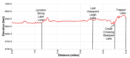
Elevation Profile
Driving Directions
From Jackson, WY: From the main square at North Cache and Broadway in Jackson Hole, WY, head north on North Cache Street (US-191 N / US-26 E) for 12.4 miles to Moose Junction and turn left on Teton Park Road. Follow Teton Park Road for 1.0 mile, past the main visitor center, to the entrance/fee station. Continue beyond the entry station for 9.8 miles to the North Jenny Lake Junction and turn left on the Jenny Lake Road.
Drive 1.5 miles on the Jenny Lake Road and then turn right onto String Lake Road. Turn right in 230-ft into the first parking lot near the foot of String Lake and park. The start of the String Lake trail is located at the south end of the parking area. This is a very small lot.
If the lot is full, continue on the String Lake Road for 0.3 miles to the parking lot at the end of the road. The Leigh Lake trailhead starts at the north end of the parking area to the left of the bathrooms. Follow the trail for 0.1 miles to String Lake. By starting the trail here you will reduce the length of the hike by 0.4 miles (one-way) of 0.8 miles (round trip). Get an early start. This is a popular area with limited parking.
From Teton Village, WY: Head out of the village and turn left on the Moose-Wilson Road. Follow the road for 1.1 miles to the park entrance/fee station. Beyond the fee station drive 6.9 miles on the narrow, winding road and turn left on Teton Park Road. Follow Teton Park Road for 0.4 miles to the park entrance/fee station. Continue beyond the entry station for 9.8 miles to the North Jenny Lake Junction and turn left on the Jenny Lake Road.
Drive 1.5 miles on the Jenny Lake Road and then turn right onto String Lake Road. Turn right in 230-ft into the first parking lot and park. The start of the String Lake trail is located at the south end of the parking area. This is a very small lot. If full, continue on the String Lake for 0.3 miles to the parking lot at the end of the road. The Leigh Lake trailhead starts at the north end of the parking area to the left of the bathrooms. Follow the trail for 0.1 miles to String Lake. By starting the trail here you will reduce the length of the hike by 0.4 miles (one-way) of 0.8 miles (round trip). Get an early start. This is a popular area with limited parking.
Trail Resources
Trail Intro / Trail Photo Gallery / Trail Map
Basecamp(s) Information:
Grand Teton NP / Jackson Hole
Region Information:
The Tetons
Other Hiking Regions in:
Wyoming