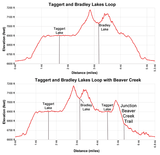
Details: Taggart and Bradley Lakes Loop 
Distance: 5.3 - 6.7 miles (loop)
Grand Teton National Park, near Grand Teton NP in The Tetons
Hike Facts
- Distance: 5.3 - 6.7 miles (loop)
- Elevation: 6,630-ft. - 7,195-ft.
- Elevation Gain: 565-ft. - 1,240-ft.
- Difficulty: easy-moderate
- Trail Highlights: See Trail Intro
- Basecamp(s): Grand Teton NP / Jackson Hole
- Region: The Tetons
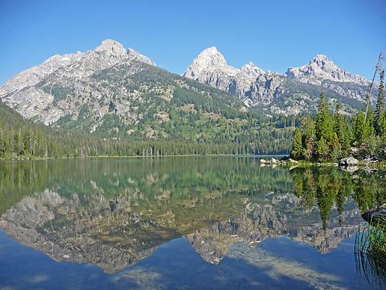
Impressive views of Tetons are the hallmark of this scenic loop trail visiting photogenic Taggart and Bradley Lake, set in beautiful basin beneath the majestic Teton Range.
Taggart and Bradley Lakes Loop
Distance from Trailhead: 5.3 miles (loop)
Ending/Highest Elevation: 7,195-ft.
Elevation Gain: 990-ft.
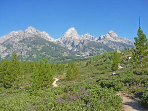
The trail to Taggart Lake starts at the northwest end of the Taggart/Bradley Lakes parking area (see driving directions below). From the trailhead kiosk the Taggart Trail heads west across rolling sagebrush flats with great views of the Tetons. Grand Teton (13,770-ft.) and Teewinot Mountain (12,325-ft.), along with Shadow Peak (10,725-ft.), Nez Pierce (11,901-ft.) and Mount Owen (12,928-ft.), fill the skyline to the west.
At 0.2 miles reach a junction with the Beaver Creek Trail. Turn right (north) to stay on the Taggart Lake trail. (The Beaver Creek Trail is the return leg of the long loop option described below.)
The trail now continues along the sagebrush flats to a bridge crossing Taggart Creek at 0.4 miles. Beyond the crossing the trail curves to the left (northwest). For the next half mile the path climbs the slopes of a moraine on moderate grades. Trees are slowly recolonizing the portion of the moraine burnt by the 1985 fire.
At 1.0 mile the trail reaches the bench atop the moraine and continues heading northwest. Here views reopen to the Teton Range rising to the west. Look carefully and you can see Shoshoko Falls tumbling down Avalanche Canyon to the south of Nez Perce Peak.
Reach a junction at 1.1 miles where the Bradley Lake trail branches right (north) to Bradley Lake. We stay left (west) heading toward the eastern shore of Taggart Lake (6,902-ft.).
Reach a junction with the Valley trail (signed for the Whitegrass Trailhead) at 1.6 miles. Here a spur trail heads to Taggart Lake (6,902-ft.) where on a still day stunning views of the Tetons are mirrored in the lake’s bluish-green water. This is a good turn-around point for parties looking for a short hike, resulting in a 3.8 mile round-trip hike with a 297-ft. elevation gain.
The junction of Taggart Lake is about 100 yards to the left (south) of the junction. It’s worth taking the 0.2 mile (round-trip) detour by turning left and following the Valley Trail south to the to the outlet stream. From the bridge over the outlet stream enjoy more fine views of the lake and the mountains.
Note: Continuing south on the Valley Trail leads to the Beaver Creek Trail, which returns to the Taggart Lake parking area. This trail, used as part of a longer loop, is covered below.
To continue the loop, return to the junction with the Taggart and Valley Trails, turn north on the Valley trail toward Bradley Lake and follow the path as it winds along the east shore of Taggart Lake. Various trails lead down to the shoreline yielding more great views and pleasant spots to take a break.
Reach the end of the lake at 2.25 mile. Here the trail climbs over a moraine separating Taggart and Bradley Lakes, gaining 250-ft. in a half mile, and then descends to the junction with the Bradley Lake trail at 3.1 miles. At the junction the Valley trail continues left (north) toward the Amphitheater Lake Junction while to the right is the last leg of the loop, the Bradley Lake trail, which leads back to the Taggart Lake parking area
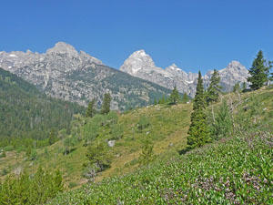
Head left (north) at the junction and soon find a trail descending to the southeast end of Bradley Lake (7,022-ft.). At the lake shore we are treated to a slightly different view of the Tetons that now includes Garnet Canyon and Middle Teton (12,804-ft.). If time and energy allow, continue along the Valley Trail to Garnet Lake’s outlet stream for fine views of Mount Wister (1,490-ft.) and Buck Mountain (11,938-ft.) towering above Avalanche Canyon. Nez Perce, Middle Teton and Grand Teton dominate the view beyond Garnet Canyon. This detour adds 0.7 miles (round-trip) to the hike.
To complete the loop, return to the junction and take the Bradley Lake trail to return to the Taggart Lake parking area. The path climbs back over the moraine on a path that is not quite as steep. The descent to the parking area is accompanied by nice views up Avalanche Canyon and more fine views of the Tetons.
At 4.0 miles reach the junction with the Taggart Lake trail. To finish the loop continue straight ahead on the Taggart Lake trail toward the parking area. Beyond the junction the trail descends from the moraine, curves to the south and soon crosses the bridge over Taggart Creek, reaching the junction with the Beaver Creek Trail at 4.9 miles. Stay left at the junction and arrive at the parking lot at 5.3 miles.
Taggart, Bradley and Beaver Creek Loop
Distance from Trailhead: 6.7 miles (loop)
Ending/Highest Elevation: 7,195-ft.
Elevation Gain: 1,240-ft.
The Taggart and Bradley Lake loop can be extended by including a section of the Valley and Beaver Creek Trails, creating a “Figure 8” loop. In the description above we return from Bradley Lake to the Taggart Lake junction at 4.0 mile. Instead of continuing to the parking area, turn right and return to Taggart Lake. At the junction of the Taggart Lake and Valley Trail at 4.5 miles, turn left on the Valley trail toward the Whitegrass Trailhead.
The trail now heads south along the Taggart lake shore and soon crosses the wood bridge over the outlet stream. Beyond the crossing the trail climbs over a moraine on moderate grades, traveling through willow patches and meadows scattered with trees. Along the way enjoy more nice views of the Tetons.
At 5.3 miles reach the junction with the Beaver Creek trail branching left (southeast). Turn left on the Beaver Creek Trail. The grade now abates as the undulating path curves to the east, traveling through trees and meadows to the north of Beaver Creek. A short distance past the junction we get our first glimpse of the creek. Deer can sometimes be seen grazing in the meadows.
At 5.9 miles the trail starts curving to the northeast, passing an area of marshy meadows before reaching sagebrush flats. The Beaver Creek Trail ends at the junction with the Taggart Lake trail at 6.5 miles. Turn right on the Taggart Lake trail and reach the parking area at 6.8 miles.
Taggart – Beaver Creek Loop
The final option is a Taggart Lake / Beaver Creek Loop, which does not visit Bradley Lake. At the junction with the Taggart and Valley Lake trail at 1.6 miles, turn left onto the Valley trail. Follow the trail past the end of Taggart Lake and over the moraine to the junction with the Beaver Trail at 2.4 miles. Follow the Beaver Creek trail to the Taggart Lake trail at 3.6 miles. Turn right on the Taggart Lake trail and reach the parking area at 3.8 miles with an elevation gain of 405-ft..
I recommend hiking the Taggart and Bradley Lake trails in the morning when you have the best views and cooler temperatures. There is little cover along the trail making this a very hot hike on a summer afternoon.
Elevation Profile
Driving Directions
From Jackson, WY: From the main square at North Cache and Broadway in Jackson Hole, WY, head north on North Cache Street (US-191 N / US-26 E) for 12.4 miles to Moose Junction and turn left on Teton Park Road. Follow Teton Park Road for 1.0 mile, past the main visitor center, to the entrance/fee station. Continue beyond the entry station for 2.4 miles and turn left into the signed parking lot for Taggart and Bradley Lakes. This is a very popular parking area and parking can be problematic during the height of the summer.
From Teton Village, WY: Head out of the village and turn left on the Moose-Wilson Road. Follow the road for 1.1 miles to the park entrance/fee station. Beyond the fee station drive 6.9 miles on the narrow, winding road and turn left on Teton Park Road. Follow Teton Park Road for 0.4 miles to the park entrance/fee station. Continue beyond the entry station for 2.4 miles and turn left into the signed parking lot for Taggart and Bradley Lakes. This is a very popular parking area and parking can be problematic during the height of the summer.
Note: A small section of the Moose-Wilson road is unpaved and rough. This route is only recommended for passenger vehicle with reasonable clearance. High clearance is preferable.
Trail Resources
Trail Intro / Trail Photo Gallery / Trail Map
Basecamp(s) Information:
Grand Teton NP / Jackson Hole
Region Information:
The Tetons
Other Hiking Regions in:
Wyoming