Backpack: Hailey Pass - Lizard Head - Cirque of the Towers Loop
Segment 5: Lonesome Lake to Big Sandy Trailhead via Jackass P
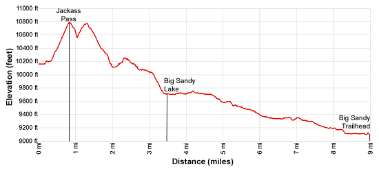
Distance: 9.0 miles (one way)
Bridger and Popo Agie Wildernesses, Bridger-Teton and Shoshone National Forests, near Big Sandy in Wyoming's Wind River Range
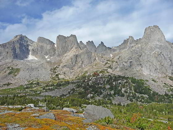
Cirque of the Towers from Jackass Pass
- Distance: 9.0 miles
- Elevation: 0.0 miles to Lonesome Lake in the Cirque of the Towers (10,166-ft.)
0.8 miles to Jackass Pass (10,790-ft.)
1.3 miles to High Point above Arrowhead Lake (10,775-ft.)
3.5 miles to Big Sandy Lake (9.690-ft.)
9.0 miles to Big Sandy Trailhead (9,085-ft.) - Difficulty: strenuous
- Basecamp: Big Sandy
- Region: Wyoming's Wind River Range
Lonesome Lake to Big Sandy Trailhead via Jackass P Description
The North Fork trail ends at the eastern shore of Lonesome Lake (10,166-ft.). Here the trail to Jackass Pass heads south along the shore. Almost immediately the trail crosses the outlet stream and then curves to the right (southwest), paralleling the shoreline. Take care to stay on the main trail, marked with rock cairns. Several use trail leading to camping areas branch left from the main trail. It is easy to get off track if you are not paying attention.
Soon the trail crosses a minor inlet stream and a short distance beyond reaches a cairned junction. Turn left (south) at the junction toward Jackass Pass. The trail straight ahead continues around the lake.
The trail now climbs on moderate and then very steep grades, zig-zagging up rocky meadows with scattered trees. As you climb enjoy ever improving views of the Cirque of the Towers. To the north are great views of Lizard Head Peak (12,842-ft.), Camels Hump (12,492-ft.) and the peaks around Texas Pass. Wolfs Head (12,163-ft.), Overhanging Tower (12,164-ft.), Sharks Nose (12,229-ft.) and Block Tower (12,210-ft.) are now in view, rising to the west of Pingora Peak (11,884-ft.). The Watch Tower and Pylon Peak (12,378-ft.) complete the scene. Warbonnet (12,369-ft.) and the Warrior Peaks (12,360-ft. and 12,406-ft.) tower above the south side of the cirque.
Soon you leave the last of the trees behind, continuing the ascent through alpine meadows to Jackass Pass (10,790-ft.), a saddle between Mitchell Peak (12,482-ft.) and Warbonnet Peak, at 0.8 miles. From the pass enjoy fine views of Lonesome Lake and the Cirque.
From the pass the trail heads south, descending steeply through alpine meadows to an unmarked junction above the north end of Arrowhead Lake (10,420-ft.). Here our trail turns left (southeast) and climbs steeply through meadows and then rock outcroppings along the western flanks of Mitchell Peak. Near the top of the climb enjoy more great views of the cirque.
Note: The trail heading right (southwest) at the junction curves around the head of Arrowhead Lake and then traverses a boulder field along the west side of the lake. The boulder field is quite difficult to negotiate when wearing a backpack. I recommend taking the main trail.
After going over a small hump the trail ascends to the high point (10,775-ft.) above Arrowhead Lake at 1.3 miles. Here views stretch south to East Temple Peak (12,620-ft.), Temple Peak (12,972-ft.) and Schiestler Peak (11,624-ft.) towering above the Deep and Temple Lake drainages.
Follow the trail as it descends on steep grades through alpine meadows growing amid rock slabs and outcroppings. Impressive Warbonnet Peak looms overhead to the west. Soon trees begin to appear as the trail drops down to a narrow valley below the foot of Arrowhead Lake.
At 1.7 miles pass a junction with a use trail branching right. This is the end of the trail traversing the boulder field along the west side of Arrowhead Lake. We continue descending on the main trail. The grade abates briefly before dropping down a very steep, rocky hillside to the head of North Lake (10,105-ft.) at 2.0 miles. Sundance Pinnacle dominates the views above the southwest side of the narrow valley.
The trail now traverses a marshy area as it curves around the north end of the lake and then briefly travels along the eastern shore. Watch for rock cairns marking the beginning of an ascent up the steep rocky slopes above the east side of the lake. A cairned route climbs up rock slabs and detours around large outcroppings high above the east side of North Lake. At times you may need to use your hands for balance as you negotiate obstacles. Take occasional breaks from the climb to enjoy the views of Sundance Pinnacle, to the southwest, and Warbonnet Peak, to the northwest.
At 2.3 miles reach the apex of the climb high above the foot of the lake. The trail now descends on moderate grades across rock slabs, around outcroppings and through rocky meadows along the east side of the narrow valley.
At 2.6 miles the trail turns right (west) and drops down to cross North Creek at 2.7 miles. On the west side of the creek the trail turns south and descends on easy grades through meadows and trees. Views open to Haystack (11,978-ft.) and Steeple Peaks (12,040-ft.) rising along the east side of the Deep Creek valley.
At 3.0 miles the trail starts a steep descent on switchbacks to Big Sandy Lake (9,690-ft.), reaching an unmarked junction above the lake’s north shore at 3.3 miles. Here a trail branches left (east/southeast), traveling through meadows around Big Sandy’s northern and eastern shores to the trails climbing to Clear, Deep and Black Joe Lakes. We bear right (southwest) on the trail dropping down to the northwest end of the lake at 3.5 miles.
The lake is a very popular place to camp. Don’t expect solitude. Campsites are located on the forested benches above the lakeshore. There is also good camping around Clear, Black Joe and Deep Lakes to the east/southeast of Big Sandy Lake.
Many people setup a basecamp at Big Sandy and then day hike to Jackass Pass and the lakes to the east/southeast. This is a good option for hikers that don’t want to lug a backpack over the Jackass Pass trail.
The trail now travels through meadows and scattered trees along the western shore of Big Sandy Lake, crossing the creek draining Blue Lake, to the east, at 3.6 miles. The lakeshore enjoys great views of Haystack, Steeple and East Temple Peak to the southeast. Big Sandy looms above the lake to the east. Dogtooth Mountain and Mitchell Peak rise along the ridge to the northwest of Big Sandy Peak. Schiestler Peak towers above the lake to the south.
Reach the southwestern end of Big Sandy Lake at 4.1 miles. Beyond the lake the trail climbs a small rise and then descends through spruce-pine forest on easy to moderate grades along the northwest side of a narrow draw, crossing three small streams along the way. A short distance beyond the third creek crossing the trail travels through a pretty meadow.
At 5.5 miles reach the junction with the trail to Diamond and V Lake branching to the right. We bear left and continue descending through trees. The trail reaches the first of two large meadows at 6.0 miles. Here the Big Sandy River meanders down the valley floor. To the northeast are views of Big Sandy Mountain and Schiestler Peak.
At the end of the second meadow, at 6.5 miles, the trail climbs over two minor humps to avoid steep sections of the river bank. Below the trail, the river cascades over the rocky riverbed.
At 7.1 miles the trail starts an easy descent along the forested fringe of another lovely meadow with fine views of the placid Big Sandy River snaking along the valley floor. Near the foot of the meadow turn around for nice views of Warbonnet Peak, Mitchell Peak, Dogtooth Mountain, Big Sandy Mountain and Schiestler Peak rising at the head of the Big Sandy Valley.
At 7.5 miles the trail reenters the trees and now descends through pine forest and intermittent meadows. Follow the trail as it curves to the right (west) at 8.0 miles and makes a short, steep decent to an oxbow bend along the river. The trail now parallels the bend in the river, crossing the Meeks Creek at 8.25 miles.
Beyond the crossing reach the junction with the Continental Divide Trail at 8.3 miles. Turn left (south) on the trail toward the Big Sandy trailhead. Follow the broad path as it travels along the west side of the Big Sandy River through meadows and trees to the trailhead at 9.0 miles.
Return to Segment 4: Valentine Lake to Cirque of the Towers Via Lizard Head
Go Back to Introduction: Hailey Pass - Lizard Head - Cirque of the Towers Loop
Elevation Profile
Backpack Segments
- Introduction: Hailey Pass - Lizard Head - Cirque of the Towers Loop
- Segment 1: Big Sandy Trailhead to Marms Lake
- Segment 2: Marms Lake to Hailey Pass Trail Junction
- Segment 3: Over Hailey Pass to Valentine Lake
- Segment 4: Valentine Lake to Cirque of the Towers Via Lizard Head
- Segment 5: Cirque of the Towers to Big Sandy Trailhead via Jackass Pass
Driving Directions to Big Sandy Trailhead
The Big Sandy Trailhead is located in the southern Wind River Range next to the Big Sandy River.
Directions from Pinedale: From the intersection of Pine Street (US 191) and North Tyler Ave (the Pinedale Tourism office is located on the northeast corner) in Pinedale, WY, drive south on Highway 191 for 11.7 miles and then turn left (east) on WY-353. After 15.5 miles you will notice signs referring to the road as the Big Sandy-Elkhorn Road and after 18 miles the paved road will change to a good packed dirt/gravel surface.
Shortly after the pavement ends go straight through a junction, and drive south crossing the Big Sandy River (Buckskin Crossing). Follow the road for a total of 27.3 miles. Shortly after crossing the Big Sandy River you will reach a junction with the Lander Cutoff Road (the next junction). Turn left on the Lander Cutoff Road. There is a wood sign at the intersection pointing toward the Big Sandy trailhead.
Drive 7.0 miles on the Lander Cutoff Road and then turn left on the Big Sandy Opening Road. Here you will see a sign for the Big Sandy Campground and trailhead. The road now deteriorates and narrows. Blind corners and lush foliage along the road make it hard to see ahead. Drive carefully, following the rocky, rutted road for 9.8 miles to a "Y" intersection. Bear right at the intersection to continue along the Big Sandy Opening Road (Forest Service Road 850). (The road branching to the left leads to the Big Sandy Lodge and Mud Lake.) Follow the road for 0.8 miles to the trailhead parking area, equipped with an outhouse.
Allow an hour and a half to reach the trailhead from Pinedale. The parking area is too small for the number of backpackers visiting the area during the height of the summer. If the parking area is full, find a safe place to park off the access road.
I recommend a high clearance vehicle to reach the trailhead. Passenger cars can make it OK if driven carefully. Check at the Pinedale ranger station before starting your trip to learn about current road and trail conditions. The Ranger Station is located to the east of the Ridleys Grocery Store on US 191 (Pine Street in Pinedale). The entrance to the ranger station is on the Fremont Lake Road. (You can also reach the parking area for the ranger station by driving east through the Ridley’s parking lot.)
This trailhead is remote, so be sure to have a full tank of gas. The dirt road become slippery when wet. The campground at the parking area is tiny, with only 4 sites. I would not plan on camping at the trailhead before starting your backpack.
Trail Resources
- Backpack Intro
- Segment Photo Gallery
- Segment Map
- Trailhead(s) Information: Big Sandy
- Region Information: Wyoming's Wind River Range
- Other Hiking Regions in: Wyoming