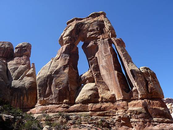
Details: Druid Arch 
Distance: 10.4 miles (round trip)
Needles District, Canyonlands National Park, near Canyonlands in Southeast Utah
Hike Facts
- Distance: 10.4 miles (round trip)
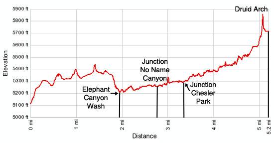
- Elevation: 5,115-ft. - 5,850-ft.
- Elevation Gain: 735-ft.
- Difficulty: strenuous
- Trail Highlights: See Trail Intro
- Basecamp(s): Canyonlands
- Region: Southeast Utah
A great hike to a high bench near the head of Elephant Canyon offering spectacular views of Druid Arch, a massive, uniquely-shaped angular arch. Along the way the trail travels through scenic Elephant Canyon, beneath sandstone walls sculpted into amazing shapes.
Trailhead to Druid Arch
The trail to Druid Arch follows the first section of the trail to Chesler Park. The trailhead is located at the southwest end of the Elephant Hill parking area (see driving directions). Just beyond the Elephant Hill trailhead bulletin board the path climbs steeply up a stone steps and ledges before heading south along a sandstone bench. Stunted pinion pines, junipers and sage grow in the thin soils covering sections of the bench. To the right (west) of the trail are impressive terracotta and white banded sandstone fins, pillars, knobs and sculpted monoliths
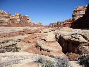
Follow the trail as it curves around the heads of two side canyons (to the east) and weaves through openings in the sandstone formations to a great viewpoint, a little over a mile from the trailhead. Here expansive views of the Needles, a conglomeration of sculpted rock pinnacles, knobs and fins, open to the south.
The trail now ascends on easy grades across a scrub covered landscape to a split in the trail at 1.3 miles. Continue straight ahead on the trail to Druid Arch and Chesler Park. (The path to the left leads to the Squaw Flats Campground.)
Past the junction the trail travels between sandstone knobs and turns southwest. In a short distance the trail swings left, squeezing through a slot between sandstone blocks, and then descends a beautiful water chiseled gorge to a viewpoint overlooking Elephant Canyon.
Beyond the viewpoint the trail drops steeply down a series of ledges and sandy slopes to the floor of Elephant Canyon, 1.9 miles from the trailhead. Cross the Elephant Canyon wash and arrive at a second junction where the path to Druid Arch turns left (south) and heads up Elephant Canyon. (The trail to Chesler Park continues straight ahead).
Note: Backpackers looking for Elephant Canyon campsite #1 (EC1) should turn right when they reach the wash. Just beyond the junction look for a sign on the west side of the wash pointing to the spur trail leading to the campsite.
The trail to Druid Arch now follows a boot beaten path, supplemented with cairns, up scenic Elephant Canyon. Interesting sandstone formations line the route. Where possible the trail travels along the adjacent benches to avoid walking in the sandy wash.
Pass the sign for Elephant Canyon campsite #2 (EC2) on the right (west) side of the wash at 2.5 miles. A short distance beyond arrive at a “Y” intersection (2.7 miles). Bear right (south) at the junction, continuing up Elephant Canyon. (The path to the left heads up a side canyon, dubbed No Name Canyon, crosses a slickrock divide and then descends into Squaw Canyon.)
The trail now travels along the wash, first through sand and then along sections covered in dark reddish-gray limestone. At 3.0 miles a sign on the right (west) marks the spur trail leading to Elephant Canyon campsite #3 (EC3).
Beyond EC3 start watching for cairns that mark where the trail leaves the wash and travels along the adjacent benches. These bypasses, while requiring some climbing, avoid sandy spots and obstacles in the wash.
Reach the junction with the trail heading right (northwest) to Chesler Park at 3.3 miles. We continue straight ahead, following the route up Elephant Canyon. A short distance beyond the junction the trail follows the contours of the canyon as it curves to the southeast and then back to the south. As you progress up the canyon the walls grow in stature and become more spectacular.
At 4.4 miles a set of rock cairns on the left (east) side of the wash mark the bypass trail circumventing a large pouroff. The cairned trail climbs through a narrow crevasse, up rock ledges and then traverses along a bench high above the east side of the wash. This section of the trail offers great views of the canyon.
Beyond the pouroff the trail briefly curves to the southeast and then the southwest before encountering a slickrock chute at 4.8 miles. The chute is easily climbed turning dry conditions. Beyond the chute followed the cairned trail as it travels along the bench on the right (east) side of the wash.
At 4.9 miles a metal ladder facilitates the climb up a rock ledge. Past the ladder the trail curves to the east and soon starts a very steep climb/scramble up a boulder choked ravine beneath massive sandstone walls. Rock cairns mark the best route through the boulders. Keep an eye out for where the trail turns right (south) and climbs to the bench beneath the arch.
Upon reaching the bench the spectacular arch springs into view. Uniquely-shaped Druid Arch is unlike other arches in the surrounding area. The angular arch, with its two narrow, elongated openings, looks more like a formation from Stonehenge then the typical Canyonlands arch, characterized by oval or half-moon shaped openings beneath a crescent shaped span.
From the broad bench enjoy great views of the magnificent formation as well as wonderful vistas of upper end of Elephant Canyon. When you are done soaking in the views retrace your steps to the trailhead.
Elevation Profile
Driving Directions
From Moab: Drive south on U.S. Highway 191 for roughly 40 miles to Utah Highway 211 (signed for Canyonlands National Park, Needles District) and turn right (west). Follow Utah Highway 211 west for 37.2 miles and turn left (west), on the road signed for the Squat Flat Campground. The turn is located 2.8 miles beyond the Visitor Center.
Drive 0.3 miles to the first intersection and turn right onto the Squaw Flat Campground B road. At the next intersection, reached in 0.2 miles, continue straight ahead. (The road is signed for Elephant Hill.) Follow the rough, winding one-lane dirt road for 2.7 miles to the trailhead parking area. The trailhead is located at the southwest end of the parking lot.
From Monticello: Drive north on U.S. Highway 191 for roughly 14.3 miles to Utah Highway 211 (signed for Canyonlands National Park, Needles District) and turn left (west). Follow Utah Highway 211 west for 37.2 miles and turn left (west), on the road signed for the Squat Flat Campground. The turn is located 2.8 miles beyond the Visitor Center.
Drive 0.3 miles to the first intersection and turn right onto the Squaw Flat Campground B road. At the next intersection, reached in 0.2 miles, continue straight ahead. (The road is signed for Elephant Hill.) Follow the rough, winding one-lane dirt road for 2.7 miles to the trailhead parking area. The trailhead is located at the southwest end of the parking lot.
From Blanding, UT: Drive north on U.S. Highway 191 for roughly 34.8 miles to Utah Highway 211 (signed for Canyonlands National Park, Needles District) and turn left (west). Follow Utah Highway 211 west for 37.2 miles and turn left (west), on the road signed for the Squat Flat Campground. The turn is located 2.8 miles beyond the Visitor Center.
Drive 0.3 miles to the first intersection and turn right onto the Squaw Flat Campground B road. At the next intersection, reached in 0.2 miles, continue straight ahead. (The road is signed for Elephant Hill.) Follow the rough, winding one-lane dirt road for 2.7 miles to the trailhead parking area. The trailhead is located at the southwest end of the parking lot.
Trail Resources
Trail Intro / Trail Photo Gallery / Trail Map
Basecamp(s) Information:
Canyonlands
Region Information:
Southeast Utah
Other Hiking Regions in:
Utah