Details: Syncline Loop 
Distance: 8.3 miles (loop)
Island in the Sky District, Canyonlands National Park, near Canyonlands in Southeast Utah
Hike Facts
- Distance: 8.3 miles (loop)
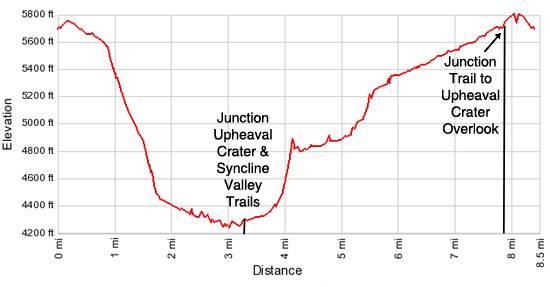
- Elevation: 5,690-ft. - 4,240-ft.
- Elevation Gain: -1,450-ft.
- Difficulty: strenuous
- Trail Highlights: See Trail Intro
- Basecamp(s): Canyonlands / Moab
- Region: Southeast Utah
This interesting and challenging trail travels around Upheaval Dome, a fascinating geological feature in the Island in the Sky district of Canyonlands National Park. The trail, recommended for experienced hikers only, descends rugged Upheaval Canyon and climbs out via a beautiful and difficult trail up the Syncline Valley.
Syncline Loop
Note: This trail is best hiked in a clockwise direction, descending into Upheaval Canyon and ascending the Syncline Valley. A steep section of the Syncline Valley trail requires hikers to scramble over boulders, climb ledges and scale a near vertical slab with some exposure. It is much easier to climb up these obstacles than to descend through the difficult course. The Syncline Valley also offers some shade in the afternoons, a welcome respite on the climb out.
The trail to the Upheaval Dome Overlook and the Syncline Loop starts at the northwest end of the parking area (see driving directions below). Walk up the trail for a short distance to a junction where the trail to the Upheaval Dome Overlook continues straight ahead. To the right and left is the Syncline Loop trail. Turn left (west) to hike the trail in the recommended clockwise direction.
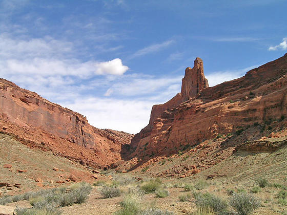
Follow the trail as it heads west along the south side of Upheaval Dome, topping a small rise and then descending on easy grades through a landscape of desert scrub and junipers. At 0.9 miles the trail passes through a gap and begins descending into Upheaval Canyon on a series of steep, rocky switchbacks. Views open to the scenic red rock canyons to the west along with occasional glimpses of the Green River.
At 1.2 miles the grade eases a bit as the trail continues its descending traverse on a bench beside a wash. After crossing the wash at 1.6 miles the trail plummets down very steep switchbacks, some covered with scree, to the Upheaval Canyon wash, 2.0 miles from the trailhead.
The trail now travels down the canyon bottom on easy grades, alternating between walking in the wash and along its adjacent benches where the footing is better. At 3.1 miles reach a trail junction. To the left (west) is the Upheaval Canyon trail, which descends to the White Rim Road near the Green River. We take the trail to the right (north), the continuation of the Syncline Loop.
Soon the trail curves to the right (east) and quickly arrives at the confluence of two washes. To the left is the Syncline Valley while straight ahead is Upheaval Dome. Pouroffs prevent travel directly up either wash. Instead the trail crosses the Syncline Valley wash and climbs stone steps to a broad bench.
Once on the bench the trail quickly arrives at the junction with a spur trail heading into and dead-ending in the Upheaval Crater at 3.4 miles. Visiting the crater will add 3.0 miles (round trip) with an elevation gain of 200-ft. to your hike. While the hike into the crater is interesting, I recommend spending the time and energy hiking the Upheaval Dome Overlook trail passed at the beginning of the Syncline Loop trail.
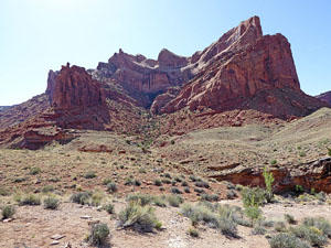
To continue along the Syncline loop turn left (northeast) and follow the trail as it ascends the beautiful Syncline Valley, initially on easy grades along the bench to the right (east) of the wash. Rising above the canyon to the west are the sheer walls of Buck Mesa while Upheaval Dome towers above the canyon to the east. Cottonwoods are scattered along wash. Depending on the time of year and rainfall you may find intermittent pools of water along the wash.
As you proceed up the valley the canyon constricts. At 4.1 miles the trail crosses to the west side of the wash and begins a very steep climb up a rocky slope, gaining over 400-ft. in 0.4 miles. This challenging part of the trail requires scrambling over boulders, climbing ledges and scaling a steep slickrock slab with some exposure. At one point along the climb a cable bolted to the wall offers a hand hold to facilitate the climb up a difficult section. Follow the rock cairns carefully through this section to stay on course.
At 4.5 miles the grade abates as the trail traverses the upper section of the canyon, traveling through grasses, brush and cottonwoods. Shade, cast by the steep canyon walls, offers a welcome relief from the afternoon sun.
At 5.5 miles the trail curves sharply to the right and soon starts climbing up a gap in the canyon’s walls, gaining 300-ft. in 0.4 miles. Cairns mark the way as the trail scales ledges, steeply ascends a slickrock chute and then climbs up a rocky section.
The rest of the hike follows a gently ascending traverse, traveling along the wash and its adjacent benches, covered in scrub, juniper and pinion pine. Turn left when you reach the junction with the Upheaval Dome Overlook trail at 8.3 miles and return to the parking area.
Hikers with additional time and energy will want to hike the Upheaval Dome Overlook trail either before or after tackling Syncline Loop. The short, popular trail offers spectacular views of Upheaval Dome and its massive crater. Interpretive signs along the way explain the two competing theories on the creation of the Dome. The easy trail reaches the first overlook at 0.3 miles (0.6 mile RT). The second overlook is a 1.7 mile round trip hike from the junction with the Syncline Loop trail.
My preference is to hike to the overlook first to avoid the crowds and gain an appreciation of the area you will be traveling around on the loop hike.
Elevation Profile
Driving Directions
From Moab: Head north on US 191 N (Main Street) for 11 miles and turn left (west) onto UT 313 W. Follow UT-313 W for 14.6 miles to the “Y” intersection where UT-313 turns left. Continue straight ahead on the Grand View Point Rd / Island in the Sky Road for 13.1 miles and turn right on the Upheaval Dome Road. Drive for 4.8 miles on Upheaval Dome Road to the end of the road and the parking area for the Upheaval Dome / Syncline Loop trailhead. The trail starts at the northwest end of the parking lot.
Trail Resources
Trail Intro / Trail Photo Gallery / Trail Map
Basecamp(s) Information:
Canyonlands / Moab
Region Information:
Southeast Utah
Other Hiking Regions in:
Utah