Details: Bow Glacier Falls 
Distance: 5.6 miles (round trip)
Banff National Park, near Banff in The Canadian Rockies
Hike Facts
- Distance: 5.6 miles (round trip)
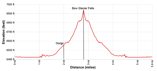
- Elevation: 6,420-ft. - 6,940-ft.
- Elevation Gain: 520-ft.
- Difficulty: easy-moderate
- Trail Highlights: See Trail Intro
- Basecamp(s): Banff / Lake Louise
- Region: The Canadian Rockies
This lovely hike traverses the shores of Bow Lake, travels through an interesting gorge and then ascends an outwash plain to the base of stunning Bow Falls tumbling down a rugged cliff.
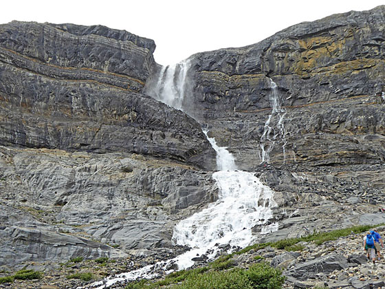
Trailhead to Bow Glacier Falls
The Bow Glacier and Bow Glacier Falls viewpoint along the Icefield Parkway is very popular. The viewpoint is located along the access road to the Num-Ti-Jah lodge. Most visitors pull into the parking lot for the viewpoint, walk down to the lakeshore, snap some photos of the lake and distant falls and then continue on their way. If time allows, the half day hike to base of Bow Glacier Falls is highly recommended.
The trailhead for the Bow Glacier Falls hike is located behind the Num-Ti-Jah Lodge at the southwest end of the parking area reserved for lodge guests. (See driving directions below.) There is a brown and yellow Parks Canada sign marking the trailhead.
From the trailhead the path heads west along the north side of gorgeous Bow Lake. Views stretch south/southwest across the lake to Crowfoot Mountain (10,022-ft.), Bow Crow Peak (9,701-ft.) and Bow Peak (9,409-ft.). To the west the spire of St. Nicholas Peak (9,639-ft.) rises to the south of the Bow Glacier. Portal Peak (9,805-ft.) and Mount Thompson (10,056-ft.) tower above the western end of the valley.
As you proceed along the lakeshore views expand to include Mount Gordon to the southwest and the peaks along the southeast side of the Icefields Parkway. Behind you, to the northeast, Cirque Peak (9,819-ft.) soars above the east side of the Icefield Parkway. The trail is generally in good shape although at times you may be forced to briefly climb above the lakeshore to avoid marshy areas.
At 1.1 miles reach the northwest end of the lake. Here the trail leaves the lakeshore near the inlet and heads southwest, traveling along the west side of a large delta. Follow the boot-beaten path across gravel flats, staying to the west of the stream. Beyond the delta the trail continues across the gravel flats to the west/northwest of the braided channels of rushing meltwater from the glacier.
Reach a small gorge at 2.0 miles. Here the trail climbs rough steps up the north side of the gorge and then traverse the rim of the gorge. Below, water gushes through the gorge’s twisted channel. Midway along the gorge a sign marks the start of the Bow Hut route branching to the left (south/southwest). A chokestone lodged between the walls of the gorge provides passage across the gorge to the start of the route to the hut.
As you travel through the gorge views open to a valley to the south. Mount Olive (10,269-ft.) and the Vulture Glacier tower above the end of the valley. The route to Bow Hut travels up the east side of this valley.
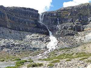
At the end of the gorge the trail climbs a small hill where terrific views open to the Bow Glacier Falls tumbling down a cleft in a rugged cliff at the head of the valley. This is the headwaters of the Bow River. The nascent river flows down the large outwash plain, an area of glacial sediment deposited by meltwater streams, covering the valley floor.
A boot-beaten path ascends the outwash plain. At times the trail breaks into multiple paths but the destination is clear. Some parties are happy to end the hike in the outwash plain and take in the scene, using the large boulders strewn across the area as viewing platforms. I recommend continuing to the base of the falls. Here you can climb rocks ledges and find a stunning perch just beside the plume of water spilling through the breach in the cliff face. A few small waterfalls, flowing through crevasses in the cliff, cascade over the rocks beside the main channel.
This is a lovely spot for lunch or just to take a break before continuing to see the sites along the Icefield Parkway. From the ledges views extend northeast to Cirque Peak and Observation Peak (10,413-ft.) towering above the east side of the Icefield Parkway. When you are done enjoying the falls, retrace your steps to the trailhead for a 5.6 miles round-trip hike.
Elevation Profile
Driving Directions
From Lake Louise: Head north on the Trans-Canada Highway AB-1 N for 1.5 miles and then take the Icefields Parkway (AB-93 N) exit toward Jasper and Rocky Mountain House. Follow AB-93 for 21.9 miles and turn left onto the spur road leading to the Num-Ti-Jah Lodge and Bow Glacier Falls. The turn is 3.0 miles south of Bow Pass on the Icefields Parkway.
There is an overflow parking area right off the Parkway. Continue past this lot to the main parking lot, 0.4 miles down the spur road. There are bathrooms along the south side of the parking area. There is also a large parking lot behind the Num-Ti-Jah Lodge that is reserved for lodge guests only.
Note: The main parking lot can get very crowded during the height of the summer. If the lot is full, park off the access road or in the overflow parking lot. Parking in the overflow parking lot will add 0.8 miles (round-trip) to the hike.
From Banff: Head north on the Trans-Canada Highway AB-1 N for 35.5 miles and then take the Icefields Parkway (AB-93 N) exit toward Jasper and Rocky Mountain House. Follow AB-93 for 21.9 miles and turn left onto the spur road leading to the Num-Ti-Jah Lodge and Bow Glacier Falls. The turn is 3.0 miles south of Bow Pass on the Icefields Parkway.
There is an overflow parking area right off the Parkway. Continue past this lot to the main parking lot, 0.4 miles down the spur road. There are bathrooms along the south side of the parking area. There is also a large parking lot behind the Num-Ti-Jah Lodge that is reserved for lodge guests only.
Note: The main parking lot can get very crowded during the height of the summer. If the lot is full, park off the access road or in the overflow parking lot. Parking in the overflow parking lot will add 0.8 miles (round-trip) to the hike.
From Field, BC Canada: Head east on the Trans-Canada Highway (BC-1 E), which turns into AB-1 when it crosses the border into Alberta, for 14.2 miles and then take the Icefields Parkway (AB-93 N) exit toward Jasper and Rocky Mountain House
Follow AB-93 for 21.9 miles and turn left onto the spur road leading to the Num-Ti-Jah Lodge and Bow Glacier Falls. The turn is 3.0 miles south of Bow Pass on the Icefields Parkway.
There is an overflow parking area right off the Parkway. Continue past this lot to the main parking lot, 0.4 miles down the spur road. There are bathrooms along the south side of the parking area. There is also a large parking lot behind the Num-Ti-Jah Lodge that is reserved for lodge guests only.
Note: The main parking lot can get very crowded during the height of the summer. If the lot is full, park off the access road or in the overflow parking lot. Parking in the overflow parking lot will add 0.8 miles (round-trip) to the hike.
Trail Resources
Trail Intro / Trail Photo Gallery / Trail Map
Basecamp(s) Information:
Banff / Lake Louise
Region Information:
The Canadian Rockies
Other Hiking Regions in:
Alberta / British Columbia