Details: Ancient Bristlecone Pine Trails at Schulman Grove 
Distance: 1.0 - 4.2 miles (loop)
Inyo National Forest, near Bishop in California's Southeastern Sierra
Hike Facts
- Distance: 1.0 - 4.2 miles (loop)
- Elevation: 10,075-ft. - 10,350-ft.
- Elevation Gain: 275-ft. - 800-ft.
- Difficulty: easy-moderate
- Trail Highlights: See Trail Intro
- Basecamp(s): Bishop / Lone Pine
- Region: California's Southeastern Sierra
Hike among some of the oldest trees in the world on two interesting trails that traverse the Ancient Bristlecone Pine forest at Schulman Grove, high atop of the White Mountains.
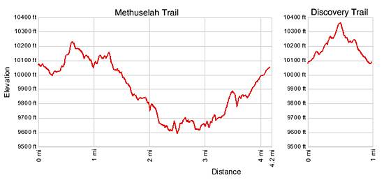
The Discovery Trail
Distance from Trailhead: 1.0 miles (loop)
Ending/Highest Elevation: 10,350-ft.
Elevation Gain: 280-ft.
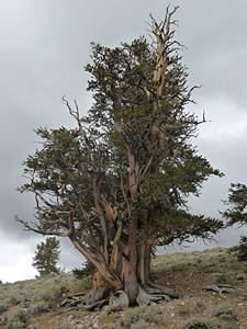
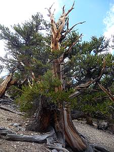
The Discovery Trail is a short interpretive trail that loops through a grove of 3,000 and 4,000 year old trees. It is in this location where Dr. Edmund Schulman first discovered a bristlecone pine over 4,000 years old, hence the name of the trail.
The easy one mile long loop gains and loses 275-ft. as it travels along a good trail with interesting views of the surrounding terrain. The trail has some amazing photogenic specimens and definitely worth the time. It begins and ends on the north side of the parking lot at the Schulman Grove, a worthwhile stop before you start your hike, and can be easily combined with the Methuselah Trail.
The Methusela Trail
Distance from Trailhead: 4.2 miles (loop)
Ending/Highest Elevation: 10,198-ft.
Elevation Gain: 800-ft.
The Methusela Trail is a 4.2 mile loop hike that journeys past ancient trees, an overlook into Death Valley National Park, a mountain mahogany woodland and the Methuselah Grove. The moderately strenuous loop traverses three ridges and two ravines on a well graded trail with an 800-ft elevation loss that must be regained on the final leg of the loop.
Numbered posts along the trail are explained in an interpretive trail guide (fee) available at the trailhead. The guide outlines the growing cycle and characteristics of the trees and explains the ecological zone that account for the various in plant species found along the trail.
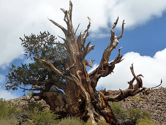
The world's oldest living tree, the Methuselah, is located along this trail although its identity is kept a secret to protect the tree from damage.
The trail starts to the east of the Schulman Grove Visitor’s Center. A worthwhile stop before your start your hike.
About the Great Bristlecone Pines
Originally classified as a foxtail pine because of the needle arrangement (like a cat or fox's tail), these trees were redesignated in the late 1800's and named bristlecone due to the long prickly "bristle" on the immature cone. In 1963, Dr. Dana K. Bailey determined that there were significant genetic and physical differences between the bristlecones in the Great Basin and those in the Rocky Mountains. His research efforts resulted in another redesignation into two separate species named bristlecone: the Rocky Mountain Bristlecone Pine and the Great Basin Bristlecone Pine.
In the White Mountain the bristlecones show a preference for growing in white rocky soil, called Dolomite, that gives the mountain range its name. Dolomite is actually a type of limestone created under the warm, shallow, inland sea that once covered this area. Most species of plants find it very difficult to grow in Dolomite soil, which is very alkaline. The bristlecones, because they have adapted to this high alkalinity, have a chance to get established and grow in a near competition-free environment.
Elevation Profile
Driving Directions
From Bishop: Take US Highway 395 south for 14.7 miles to Big Pine and turn left (east) onto State Highway168 just north of Big Pine. Follow Highway 168 east for 13 miles to the White Mountain Road. Turn left (north) and drive 10 miles to the Schulman Grove Visitor Center at the end of the paved road. At the visitor center pickup trail maps and pay the entrance fee. Note: The White Mountain Road to Schulman Grove is a paved narrow, winding mountain road. Travel time from Bishop to the Schulman Grove is approximately one hour each way.
From Lone Pine: Take US Highway 395 north for 42.6 miles to Big Pine and turn right (east) onto State Highway168 just north of Big Pine. Follow Highway 168 east for 13 miles to the White Mountain Road. Turn left (north) and drive 10 miles to the Schulman Grove Visitor Center at the end of the paved road. . At the visitor center pickup trail maps and pay the entrance fee. Note: The White Mountain Road to Schulman Grove is a paved narrow, winding mountain road. Travel time from Lone Pine to the Schulman Grove is approximately 1.5 hours each way.
Trail Resources
Trail Intro / Trail Photo Gallery / Trail Map
Basecamp(s) Information:
Bishop / Lone Pine
Region Information:
California's Southeastern Sierra
Other Hiking Regions in:
California