Details: Electric Pass 
Distance: 9.2 miles (round trip)
Maroon Bells-Snowmass Wilderness, White River National Forest, near Aspen in Central Colorado
Hike Facts
- Distance: 9.2 miles (round trip)
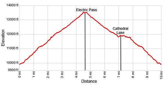
- Elevation: 9,880-ft. - 13,500-ft.
- Elevation Gain: 1,910-ft. - 3,620-ft.
- Difficulty: strenuous-difficult
- Trail Highlights: See Trail Intro
- Basecamp(s): Aspen
- Region: Central Colorado
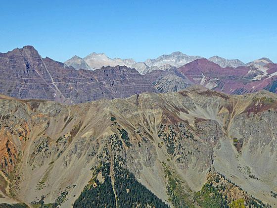
A strenuous hike to the highest trail pass in Colorado featuring spectacular views of the high peaks and ridges of the Elk Mountains, including Castle and Cathedral Peaks to the southwest and the Maroon Bells, Snowmass Mountain, Pyramid Peak and Capital Peak to the northwest.
Trailhead to the Junction with Electric Pass

Distance from Trailhead: 2.3 miles (one way)
Ending/Highest Elevation: 11,790-ft.
Elevation Gain: 1,910-ft.
The trail to Cathedral Lake and Electric Pass wastes no time gaining altitude. From the parking area (see driving directions) the trail immediately starts climbing through beautiful groves of mature aspen. Soon the trail curves to the west and enters the Pine Creek Valley at an overlook with scenic views of the upper Castle Creek valley.
Once in the Pine Creek drainage the ascent steepens as the trail climbs above the north side of Pine Creek through aspen groves that give way to spruce/fir forest. Pine Creek rushes down the ever deepening gorge beside the trail. At 0.7 miles the trail passes a pretty waterfall along the creek.
Past the falls the trail continues its ascent on steep grades. Meadows and openings in the trees offer fine views of the rugged ridge rimming the south side of the valley. Be sure to turn around for nice views across the Castle Creek Valley.
The grade abates at 1.5 miles as the trail crosses a boulder field created by rock slides cascading from the steep slopes to the north of the trail. The boulder field provides the first views of the peaks at the head of the valley.
Beyond the boulder field the trail traverses a stand of trees and then follows gentle grades as it curves to the right (northwest) above a boggy, willow-choked meadow at 1.6 miles. The open meadow offers fine views of Malamute Peak (13,348-ft.) and several unnamed peaks rising above the head of the valley.
Past the meadow the trail turns left (west) and climbs through scrub brush and trees, crossing a small rockslide beneath the south facing slopes of Leahy Peak (13,322-ft.) at 1.7 miles. The grade steepens at 2.0 miles as the path crosses a large talus field and then ascends steep switchbacks up the basin's headwall.
Crest the top of the headwall at 2.2 miles. The grade now moderates as the trail heads southwest and soon reaches a junction at 2.3 miles. Here the trail to Electric Pass turns right (west). The trail straight ahead leads to Cathedral Lake.
Junction to Electric Pass

Distance from Trailhead: 9.2 miles (round trip)
Ending/Highest Elevation: 13,500-ft.
Elevation Gain: 3,620-ft.
To hike to Electric Pass, turn right at the junction and follow the trail as it climbs a hillside though willows and scattered trees. Reach a second intersection at 2.5 miles with an unmarked trail heading left to Cathedral Lake. Bear right at the second junction to stay on the trail to the pass. (The trail to the left will be used on the return leg of the hike to visit the lake.)
As you head toward the pass turn around and look south to see Cathedral Lake nestled in a rocky bowl beneath Malamute Peak. To the west the spires along Cathedral Peak’s north ridge are now in view. Peak 13635 towers above the valley to the north while Leahy Peak rises to the east. The trail to Electric Pass will ascend to the saddle on the ridge between the two peaks.
Beyond the junction the path begins a steep ascent through willow thickets and pretty alpine meadows, skirting the east side of the huge talus field beneath Cathedral Peak’s north ridge. At 3.0 miles the trail turns right (east and then southeast) as it climbs steeply up meadows sprinkled with wildflowers beneath the west facing slopes of Leahy Peak.
At 3.25 miles the trail turns left (northwest), continuing the steep climb up switchbacks toward the saddle between Peak 13635 and Leahy Peak. As you climb enjoy the ever improving panorama of summits, including Malamute Peak, Cathedral Peak (13,943-ft.) and Castle Peak (14,265-ft.), to the southwest.
Reach the saddle on the ridge at 4.1 miles where views stretch east/northeast to a sea of peaks and ridges in the Collegiate Peaks and Hunter-Fryingpan Wilderness areas. To the southwest are grand views of Cathedral Lake, Cathedral Peak, Castle Peak and the summits towering above the head of the Castle Creek Valley.
The trail now climbs a series of steep switchback up the ridge to the northwest of the saddle. At 4.25 miles the trail turns left (west), following a narrow, exposed trail ascending along steep scree slopes beneath Peak 13635. Exercise extreme caution along this section of the trail. The footing is not great in areas where the trail crosses minor rockslides. Not everyone is comfortable on this section of the trail. If in doubt, turn around.
Reach Electric Pass (13,500-ft.) at 4.6 miles. The pass, situated on the ridge running between Cathedral Peak and Peak 13635, is located well above the low point on the ridge and just 135-ft. below Peak 13635. You only need to look at the steep cliffs below the low point on the ridge to understand the routing of the trail.
From the pass stunning views extend west/northwest to the high peak of the Maroon Bells-Snowmass Wilderness. On a clear day you can see a quintet of 14ers; Maroon Peak (14,156-ft.), North Maroon Peak (14,014-ft.), Pyramid Peak (14,018-ft.), Snowmass Mountain (14,092-ft.) and Capitol Peak (14,130-ft.). Cathedral Peak soars above the ridge to the southwest. To the south the peaks towering above the head of the Castle Creek Valley form the backdrop for Cathedral Lake, nestled in a rocky bowl beneath Malamute Peak. Distant views of the Collegiate Peaks fill the skyline to the east.
When you are done enjoying the views, carefully work your way back to the saddle and then descend the alpine meadows to the junction with a use trail dropping down to Cathedral Lake at 6.6 miles. If time, energy and the weather permit, I strongly recommend a side trip to visit Cathedral Lake. The side trip adds about 0.7 miles to the hike, making the trip to the pass and the lake 9.9 miles (round trip). Otherwise, retrace your steps to the trailhead.
Please note that the trail to Electric Pass is not recommended for anyone with a fear of heights or hikers uncomfortable on narrow, exposed trails.
Optional Side Trip to Cathedral Lake

Distance from Trailhead: 0.7 miles (round trip)
Ending/Highest Elevation: 11,866-ft.
Elevation Gain: -1,634-ft.
To visit the lake, turn right (south) at the junction with the use trail to Cathedral Lake and follow the path as it curves to the southeast, dropping steeply to a second junction at 6.9 miles near Cathedral Lake’s outlet stream. The path to the left (east/northeast) descends to the trailhead. Cross the outlet stream and turn right (south/southwest), joining the main trail to Cathedral Lake. The trail now ascends on moderate grades through meadows and willow thickets to the shelf cradling Cathedral Lake at 7.1 miles.
Cathedral Lake (11,866-ft.) is an alpine jewel surrounded by jagged peaks, crags and rugged cliffs. Cathedral Peak towers above the lake to the west while Malamute Peak rises to the southwest. From the south end of the lake fine views extend north toward Electric Pass.
The lake is a popular destination, so do not expect solitude. Thankfully the eastern shoreline is long enough to allow parties to spread out and enjoy the lovely setting.
When you are done lazing around the lake, follow the trail back to the outlet stream. Cross the creek and turn right (east/northeast) at the junction on the other side of the creek. The trail now descends on easy grades to the first junction with the trail to Electric Pass at 7.6 miles. From here retrace your steps to the trailhead for a 9.9 mile hike.
Elevation Profile
Buy the BookThis opinionated guide includes all the hikes in the Aspen, Buena Vista, Crested Butte, Marble and Leadville sections of the website plus info on local services and nearby attractions. | |

Driving Directions
Driving Directions from Aspen:
Drive 0.5 miles west of Aspen on CO 82 to the roundabout. Go around the roundabout and turn right at the Castle Creek Road. (The Castle Creek Road is the third exit on the roundabout when heading west on CO 82.) Drive 12.2 miles on the Castle Creek Road and turn right onto a gravel road signed for the Cathedral Lake trail. The turn is shortly after Ashcroft, a restored ghost town open to the public. Continue 0.5 miles up the rough gravel/dirt road. Over the years the road has deteriorated. Passenger vehicles with good clearance, if driven carefully, can make it to the trailhead parking area.
This is a popular trailhead and the lot fills early during the summer. If the lot is filled, additional parking can be found along the access road.
Trail Resources
Trail Intro / Trail Photo Gallery / Trail Map
Basecamp(s) Information:
Aspen
Region Information:
Central Colorado
Other Hiking Regions in:
Colorado