Details: Midway Pass 
Distance: 7.8 miles (round trip)
Hunter-Fryingpan Wilderness, White River National Forest, near Aspen in Central Colorado
Hike Facts
- Distance: 7.8 miles (round trip)
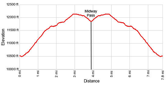
- Elevation: 10,530-ft. - 12,140-ft.
- Elevation Gain: 1,620-ft.
- Difficulty: moderate
- Trail Highlights: See Trail Intro
- Basecamp(s): Aspen
- Region: Central Colorado
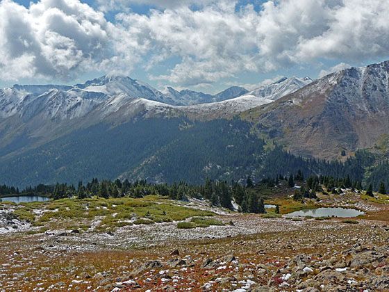
Great views of the Collegiate Peaks and the Elk Mountains beyond, solitude and a good workout are your rewards for hiking this lightly used trail to a pass high in the Williams Mountains.
Trailhead to Midway Pass

The trail to Midway Pass starts at the Lost Man trailhead (see driving directions) and follows the Lost Man trail as it heads west, quickly crossing a wood bridge over Lost Man Creek. Beyond the crossing the trail curves to the right (northeast) and ascends on easy grades to a junction at 0.4 miles. Turn left (northwest) at the junction on the trail toward Midway Pass. The Lost Man trail continues straight ahead toward the Lost Man Reservoir.
The path now climbs steeply up a forested hillside on 18 switchbacks. Openings in the trees offer nice views of Green Mountain (12,791-ft.), Independence Peak (12,703-ft.) and other nearby summits towering above the south side of the Roaring Fork valley. Geissler Mountain rise to the east across the Lost Man Valley.
Reach the top of the switchbacks and the boundary for the Hunter Fryingpan Wilderness at 1.4 miles. The trial now continues its ascents on moderate grades through spruce-fir forest. Soon the grade abates as the trail travels along a wooded bench.
At 2.0 miles the trees give way to wet meadows and dense willow patches. After a short climb the trail curves left (west), crosses a braided stream and then ascends on easy grades. Depending on the time of year you may cross a few more small streams trickling down the slopes above the trail.
Once above timberline the trail enjoys fine views of Green Mountain, Independence Peak and the summits of the Collegiate peaks wilderness to the south of the Roaring Fork Valley. To the southwest are distant views of the high peaks in the Maroon Bells-Snowmass Wilderness. On a clear day you should be able to pick out Castle Peak (14,265-ft.) and Cathedral Peak (13,943-ft.). Peak 13033 towers above the trail to the north.
The climb resumes on moderate grades at 2.4 miles. Follow the trail as it skirts the right (north) side of a small, photogenic tarn at 2.7 miles and then turns to the right (northwest). The trail now ascends through alpine tundra to a bench beneath the west side of Peak 13033 at 3.0 miles. This is the high point of the hike at 12,140-ft. From the bench views open to the peaks rising along the west side of Midway Pass.
After a brief stint traveling along the bench, the trail drops on easy grades through alpine tundra along the right (east) side of the Coleman Creek drainage. At 3.5 miles the descent steepens as the trail gradually swings left (northwest), crosses a small stream and then drops to the saddle dividing the Coleman Creek and Midway Creek drainages. This is Midway Pass (11,840-ft.) at 3.9 miles.
The pass is pleasant but hardly the highlight of the trip. The steep valley walls on either side of the saddle limit the views. Green Mountain towers above the Roaring Fork valley to the south. View stretch north into the Hunter-Fryingpan Wilderness. Nearer at hand a small tarn lies nestled in a boggy meadow beneath unnamed 12,000-ft. peaks.
For day hikers the pass is a good turn around point. On the north side of the pass the Midway Trail descends the Midway Valley and connects with the Hunter Creek Trail at 8.6 miles and the Woody Creek Trail at 10.6 miles, providing opportunities for overnight trips into the Hunter Fryingpan Wilderness.
Elevation Profile
Buy the BookThis opinionated guide includes all the hikes in the Aspen, Buena Vista, Crested Butte, Marble and Leadville sections of the website plus info on local services and nearby attractions. | |

Driving Directions
Driving Directions from Aspen: Drive 14 miles east of Aspen on Highway 82 to the Lost Man trailhead parking area on the left (north) side of the road. The parking lot is directly across from the Lost Man Campground. The trail begins on the left (north) side of the parking area and initially follows the Lost Man trail.
Trail Resources
Trail Intro / Trail Photo Gallery / Trail Map
Basecamp(s) Information:
Aspen
Region Information:
Central Colorado
Other Hiking Regions in:
Colorado