Details: Lake Ann 
Distance: 6.6 - 12.0 miles (round trip)
Collegiate Peaks Wilderness, San Isabel National Forest, near Buena Vista in Central Colorado
By: Diane Greer
Hike Facts
- Distance: 6.6 - 12.0 miles (round trip)
- Elevation: 10,600-ft. - 12,620-ft.
- Elevation Gain: 1,205-ft. - 2,020-ft.
- Difficulty: moderate
- Trail Highlights: See Trail Intro
- Basecamp(s): Buena Vista / Leadville
- Region: Central Colorado
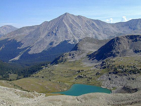
The hike to Lake Ann, cradled in a pretty alpine basin beneath the Continental Divide, features great views of Huron Peak and the Three Apostles. Continue the hike to a saddle on the divide with stunning views of the Taylor Valley and the peaks riming the Clear Creek valley.
To Lake Ann
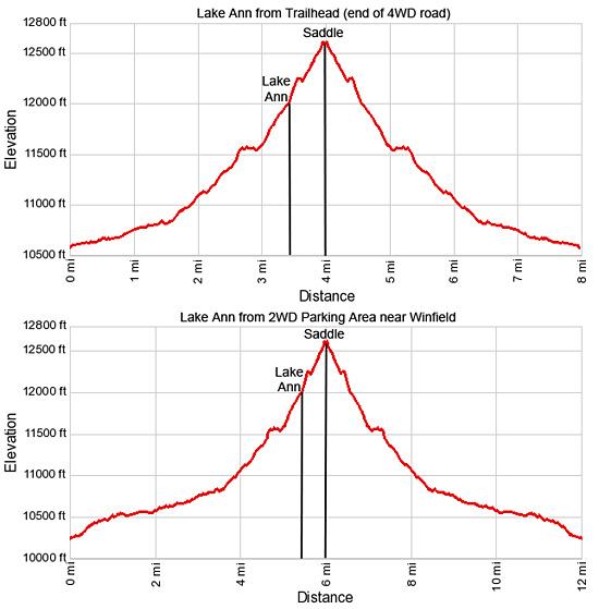
Distance from Trailhead: 6.6 miles (round trip)
Ending/Highest Elevation: 11,805-ft.
Elevation Gain: 1,205-ft.
Distance from 2WD Trailhead: 10.6 miles (round trip)
Ending/Highest Elevation: 11,805-ft.
Elevation Gain: 1,549-ft.
From the 2WD parking lot near Winfield, walk south up County Road (CR) 390.2B on easy grades for 0.7 miles to an intersection. Take the road branch right to stay on CR 390. (The road to the left climbs the hill towards Browns Peak.)
Continue up the road for 1.3 miles to the 4WD parking area for Lake Ann and Huron Peak. The walk to the trailhead gains about 350-ft. in 2.0 miles, adding 4.0 miles round trip to the hike to Lake Ann. The mileage in the description below assumes you are starting from the 4WD Parking area.
Before beginning the hike to Lake Ann, walk to the pond to the west of the trailhead parking area for fine views of the peaks rising above the head of the Silver Creek basin to the southwest. Granite Mountain (12,848-ft.), a distinctive triangular peak, towers above the ridge separating the Silver Creek and the South Fork valleys.
The trailhead for Lake Ann and Huron Peak (14,003-ft.) is located at the south end of the 4WD parking area. Here the path to Huron Peak branches to the left (southeast). We head south on the Lake Ann/Continental Divide trail, which curves around the large sign at the trailhead.
Follow the trail as it ascends on easy grades through spruce-fir forest and small meadows on the east side of the South Fork valley. Along the way the trail passes the boundary for the Collegiate Peaks Wilderness. At 0.9 miles cross a large meadow with a pond where views open to the Three Apostles (West Apostle (13,568-ft.), Ice Mountain (13,951-ft.) and North Apostle (13,860-ft.)) rising to the southwest. Huron Peak (14,003-ft.) soars overhead to the east.
Beyond the meadow the trail wanders through clusters of trees and brushy meadows. Keep an eye out for the ruins of an old cabin across the creek. Reach a “Y” intersection in a meadow at 1.5 miles. The Three Apostles trail branches left. We bear right (southwest) on the trail to Lake Ann. Ahead are fine views of the Apostles.
Past the junction the trail crosses to the west side of the South Fork of Clear Creek on a make-shift log bridge and briefly travels through willow-clogged meadows before curving to the left (south). Soon the trail enters the forest, climbing south/southwest on moderately-steep grades. Views are limited as the path climbs through the trees although a few nice waterfalls along the creek add interest to this section of the trail.
Cross a small cascade tumbling down from Harrison Flats at 2.8 miles. A short distance beyond the trail curves to the left (southeast) as it descends to and crosses a creek. On the east side of the creek the trail climbs steeply through trees which soon give way to meadows.
At 3.2 miles reach the junction with the use trail branching left to Lake Ann (11,805-ft.), an aquamarine jewel nestled in a beautiful basin beneath rugged 13,000-ft peaks. The trail to the right climbs to a saddle on the Continental Divide.
To Saddle on the Continental Divide
Distance from Trailhead: 8.0 miles (round trip)
Ending/Highest Elevation: 12,620-ft.
Elevation Gain: 2,020-ft.
Distance from 2WD Trailhead: 12 miles (round trip)
Ending/Highest Elevation: 12,620-ft.
Elevation Gain: 2,364-ft.
A visit to the saddle on the Continental Divide is highly recommended. The trail to the divide ascends steeply along the meadow-clad ridge to the west of the lake. Rock cairns mark the way. As you gain elevation enjoy great views of the lake and the peaks along the divide. West Apostle towers above the basin to the southwest while the summits of Ice Mountain and North Apostle are seen through a gap in the ridge to the east.
Soon the trail starts climbing steep switchbacks up the divide’s talus slopes, reaching the saddle on the ridge at 4.0 miles. From the saddle enjoy panoramic views of the Taylor Valley and reservoir to the southwest and the Elk Mountains to the west. Huron Peak dominates the views to the northeast while Mount Hope (13,993-ft.), Ervin Peak (13,531-ft.) and Mount Blaurock (13,616-ft.) rim the Clear Creek Valley to the north. La Plata Peak (14,336-ft.) towers above the peaks to the northwest.
After taking in the views from the divide descend to the pretty meadows surrounding Lake Ann for impressive views of the steep sided cirque surrounding the lake and the nearby peaks. Backpackers camping in the vicinity of the Lake Ann will want to explore the unnamed lakes of Harrison Flats to the west. The lakes enjoy stunning views of the Three Apostles and Huron Peak.
After visiting the divide and Lake Ann, retrace your steps to the trailhead for an 8.0 mile round-trip hike.
Elevation Profile
Buy the BookThis opinionated guide includes all the hikes in the Aspen, Buena Vista, Crested Butte, Marble and Leadville sections of the website plus info on local services and nearby attractions. | |

Driving Directions
Driving Direction from Buena Vista: From the traffic light at the intersection of U.S.24 and Country Road 306 in downtown Buena Vista, travel north on U.S. Hwy 24 for 15 miles to County Road (CR) 390 / Clear Creek Reservoir Road. Turn left (west) on Clear Creek Road / CR 390 and follow the gravel road, which turns into Forest Road 120, for 11.7 miles to the ghost town of Winfield.
In Winfield turn left (south) on Forest Road (FR) 390.2B. The road crosses Clear Creek on a bridge. Hikers who do not have a high clearance/4WD vehicle should turn left (east) after 0.1 miles into a large parking lot and camping area.
If you have a high clearance/4WD vehicle, continue 0.7 miles on the rough road to an intersection and bear right. (Don’t take the road to the left that heads uphill towards Browns Peak.) Continue up FR 390.2b for 1.3 miles to the parking lot at the end of the road. (Total distance from the Clear Creek Road to the trailhead is 2.0 miles.) Note: This road crosses streams and negotiates deep ditches and potholes. Don’t try to take a 2WD, low clearance vehicle on this road.
The small 4WD parking area can get quite crowded since it also serves as the parking lot for Huron Peak, a popular 14er.
Driving Direction from Leadville: Travel south on U.S. Hwy 24 for 19.5 miles to County Road (CR) 390 / Clear Creek Reservoir Road. Turn right (west) on CR 390 and follow the gravel road, which turns into Forest Road 120, for 11.7 miles to the ghost town of Winfield.
In Winfield turn left (south) on Forest Road (FR) 390.2B. The road crosses Clear Creek on a bridge. Hikers who do not have a high clearance/4WD vehicle should turn left (east) after 0.1 miles into a large parking lot and camping area.
If you have a high clearance/4WD vehicle, continue 0.7 miles on the rough road to an intersection and bear right. (Don’t take the road to the left that heads uphill towards Browns Peak.) Continue up FR 390.2b for 1.3 miles to the parking lot at the end of the road. (Total distance from the Clear Creek Road to the trailhead is 2.0 miles.) Note: This road crosses streams and negotiates deep ditches and potholes. Don’t try to take a 2WD, low clearance vehicle on this road.
The small 4WD parking area can get quite crowded since it also serves as the parking lot for Huron Peak, a popular 14er.
Trail Resources
Trail Intro / Trail Photo Gallery / Trail Map
Basecamp(s) Information:
Buena Vista / Leadville
Region Information:
Central Colorado
Other Hiking Regions in:
Colorado