Anthracite Pass 
Distance: 2.5 - 6.8 miles
Raggeds Wilderness, White River National Forest, near Marble in Central Colorado
By: Diane Greer
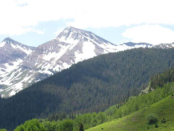
Thompson Peak and the Yule Creek Drainage
The Anthracite Pass trail features excellent views of Treasure Mountain and Marble Peak with Daly Peak in the distance. The trail is a nice 3.5-4.5 hour hike that can be hiked from late June to October (snow dependent).
- Distance: 2.5 - 6.8 miles (RT)
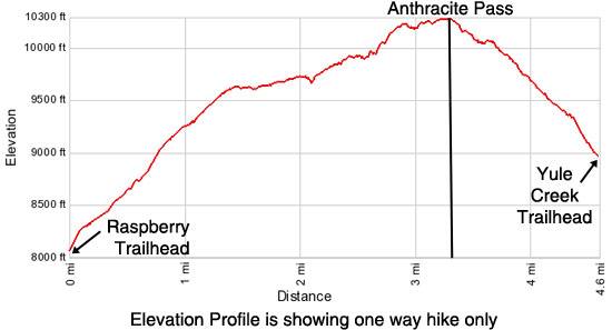
- Elevation: 8,081-ft. at Trailhead
Maximum elevation - 10,295-ft. - Elevation Gain: 2,214-ft.
- Difficulty: moderate
- Basecamp: Marble / Aspen
- Region: Central Colorado
Trail Description - Anthracite Pass
Raspberry Trailhead to Anthracite Pass or Yule Creek Trailhead
- Distance: 6.8 mile (RT)
- Elevation: 8,081 at Trailhead
- Maximum elevation 10,295-ft.
- Elevation Gain: 2,214-ft.
- Difficulty: moderate
Park at Mill Park in Marble or drive up the Quarry Road to the 3 parking spots below the trailhead (see driving directions below). The hike starts out steep, but gets more enjoyable after the first mile. You will be hiking up an avalanche chute that runs every winter from No Name Peak to the Crystal River. The force of nature is evident by the sheer number of bent trees and thick undergrowth. Reach a trail junction (9,124-ft,) at 0.85 miles and turn left on the Anthracite Pass trail. The trail to the right is the Raspberry Creek Loop.
Beyond the junction the trail continues its ascent on moderate to moderate-steep grades. At 1.3 miles the trees give way to meadows and the trail becomes quite scenic with views of Treasure Mountain, Ant Mountain, Thompson Peak and Marble Peak. Soon the grade abates as the trail travels along the base of the ridge rimming the west side of the Yule Valley. Along the way the trail travels through numerous aspen groves and lush meadows.
At 2.0 miles the trail crosses the first of several deep ravines/creek beds. Keep your eyes open for rock cairns or slashings to stay on the trail. The final crossing has a large rock cairn to mark the trail.
Beyond the last ravine, at 2.5 miles, the trail climbs steeply up a hillside through a beautiful mature pine forest and then traverses below Marble Peak to Anthracite Pass. Anthracite Pass (10,295-ft.), at 3.4 miles, is located on a flat bench where several trails meet. Nearby pine trees block most of the views at the pass. For the best view move 300-ft. north of the pass where you can enjoy excellent views of the Raggeds Wilderness including Treasure Mountain and Marble Peak. Mount Daly can be seen in the distance.
Most hikers will turn around at the pass and retrace their steps back to their cars for a 6.8 mile round trip hike. Another great option is to hike up Mt. Justice (bring a map or GPS). This is an off-trail route.
Groups with two cars or who have made prior arrangements for a car shuttle can turn left and descend an obvious trail to the Yule Creek Trailhead for a 4.6 mile hike, or back to Marble via the Quarry Road for a 7.4 mile hike. (See the Yule Creek to Anthracite Pass description below.)
Yule Creek Trailhead to Anthracite Pass
- Distance: 2.5 miles (RT)
- Elevation: 8,985-ft. at Trailhead
- Maximum elevation: 10,295-ft.
- Elevation Gain: 1,310-ft.
- Difficulty: moderately-strenuous
An alternative start to the hike is 2.8 miles up the 4WD Quarry Road at the Yule Creek trailhead (8,981-ft.). Either walk up the road or drive to the trailhead. (There is very limited parking at the trailhead.) The trailhead is located about a quarter mile from the Yule Quarry. The trail initially travels along the Yule Creek trail for a short distance. Soon you will see a trail branching to the right toward Anthracite Pass. Turn right and follow the steep trail for 1.25 miles as it gains 1,310-ft. to the pass (10,295-ft.).
Trail information provided by G. Trantow. All photos copyright G. Trantow.
Elevation Profile
Driving Directions
From Marble: In Marble turn onto the Quarry Road (Fire Station on corner). Drive 0.25 miles from the bridge over the Crystal River on Quarry Road to a small parking lot on your right. The trailhead is 0.33 miles from the bridge. This is a dirt road but well maintained.
Note: Overflow parking is available at Mill Park. Parking at Mill Park adds 0.25 miles (one way) to the hike.
If starting the hike at the Yule Creek Trailhead, drive 2.8 miles up the 4WD Quarry Road. Parking is VERY limited at the Yule Creek trailhead. The Marble Chamber of Commerce warns drivers to exercise caution on the Quarry Road. You may encounter a large white truck from the marble quarry descending the road. If so, find a wide spot on the road and get out of the way. The truck will take the inside lane, all other vehicles must stop on the outside of the road and give way to the truck. These trucks can carry up to 50-tons of marble.
From Aspen: Head West on CO-82 for 35 miles and turn left (south) on Colorado Hwy 133. Follow CO-133 for 25 miles, passing Carbondale, and turn left on County Road 3. Travel along CR-3 for 6 miles to the town of Marble. In Marble turn onto the Quarry Road (Fire Station on corner). Drive 0.25 miles from the bridge over the Crystal River on Quarry Road to a small parking lot on your right. The trailhead is 0.33 miles from the bridge. This is a dirt road but well maintained.
Note: Overflow parking is available at Mill Park. Parking at Mill Park adds 0.25 miles (one way) to the hike.
If starting the hike at the Yule Creek Trailhead, drive 2.8 miles up the 4WD Quarry Road. Parking is VERY limited at the Yule Creek trailhead. The Marble Chamber of Commerce warns drivers to exercise caution on the Quarry Road. You may encounter a large white truck from the marble quarry descending the road. If so, find a wide spot on the road and get out of the way. The truck will take the inside lane, all other vehicles must stop on the outside of the road and give way to the truck. These trucks can carry up to 50-tons of marble.
Trail Resources
- Trail Photo Gallery
- Trail Maps
- Basecamp(s) Information: Marble / Aspen
- Region Information: Central Colorado
- Other Hiking Regions in: Colorado