Raspberry Creek Loop 
Distance: 9.4 miles
Raggeds Wilderness, White River National Forest, near Marble in Central Colorado
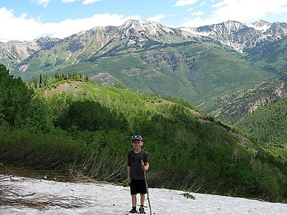
View North to Mt. Daly. All photos copyright G. Trantow.
This great loop hike starts by ascending the pretty Raspberry Creek Valley to Marble Peak (11,314-ft.). The trail then descends to Anthracite Pass and returns via the Raspberry Creek/Anthracite Pass trail. From the peak enjoy panoramic views of Snowmass Mountain, Capital Peak, Treasure Mountain and beyond.
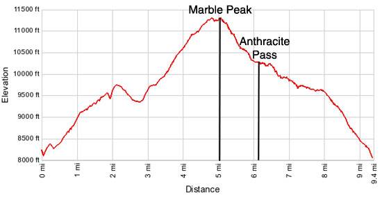
- Distance: 9.4 miles (Loop)
- Elevation: 8,081-ft. at Trailhead
Maximum elevation - 11,314-ft. - Elevation Gain: 3,233-ft.
- Difficulty: strenuous
- Basecamp: Marble / Aspen
- Region: Central Colorado
Trail Description - Raspberry Creek Loop
Proceed 0.33 miles up the Quarry Road from Crystal River Bridge. Turn right at the Raspberry Trailhead. The hike starts out steep, but gets more enjoyable after the first mile. You will be hiking up an avalanche chute that runs every winter from No Name Peak to the Crystal River. The force of nature is evident by the sheer number of bent trees and thick undergrowth. Look for fresh Raspberries in the late summer.
At 0.85 miles (9,124 ft) you will come to the trail intersection. Go right on the Raspberry Creek trail. The trail to the left, the Anthracite Pass trail, will be used on the return leg of the loop.
The trail gets steep at 3.5 miles until you top out on a high ridge (11,200 ft.). If the trail gets faint just follow game trails to the ridge. Go left along the ridge to the top of Marble Peak (11,314-ft.) at 5.0 miles. From the top of the peak enjoy panoramic views of the Elk Mountains, including Snowmass Mountain and Capitol Peak to the northeast. Treasure Mountain rises to the east.
Follow the trail that descends steeply from Marble Peak to Anthracite Pass, dropping 1,000 feet in a little over a mile. Turn left at Anthracite Pass and descend the Anthracite Pass trail to the trailhead. Alternatively you can drop down to the Yule Creek Trailhead. (See the Anthracite Pass trail for more information on the options for the return leg of this hike.)
Trail information provided by G. Trantow. All photos copyright G. Trantow.
Elevation Profile
Driving Directions
From Marble: In Marble turn onto the Quarry Road (Fire Station on corner). Drive 0.25 miles from the bridge over the Crystal River on Quarry Road to a small parking lot on your right. The trailhead is 0.33 miles from the bridge. This is a dirt road but well maintained.
Note: Overflow parking is available at Mill Park. Parking at Mill Park adds 0.25 miles (one way) to the hike.
From Aspen: Head West on CO-82 for 35 miles and turn left (south) on Colorado Hwy 133. Follow CO-133 for 25 miles, passing Carbondale, and turn left on County Road 3. Travel along CR-3 for 6 miles to the town of Marble. In Marble turn onto the Quarry Road (Fire Station on corner). Drive 0.25 miles from the bridge over the Crystal River on Quarry Road to a small parking lot on your right. The trailhead is 0.33 miles from the bridge. This is a dirt road but well maintained.
Note: Overflow parking is available at Mill Park. Parking at Mill Park adds 0.25 miles (one way) to the hike.
Trail Resources
- Trail Photo Gallery
- Trail Maps
- Basecamp(s) Information: Marble / Aspen
- Region Information: Central Colorado
- Other Hiking Regions in: Colorado