Details: Sperry Chalet via the Gunsight Pass Trail 
Distance: 12.4 miles (round trip)
Glacier National Park, near West Glacier in Glacier Natl Park, MT
Hike Facts
- Distance: 12.4 miles (round trip)
- Elevation: 3,190-ft. - 6,550-ft.
- Elevation Gain: 3,360-ft.
- Difficulty: moderate-strenuous
- Trail Highlights: See Trail Intro
- Basecamp(s): West Glacier
- Region: Glacier Natl Park, MT
A sustained ascent through trees for 4.0 miles and then more open terrain leads to the foot of stunning Glacier Basin, the Sperry Chalet and Sperry Campground. The area is a great basecamp for visiting the Sperry Glacier, Lincoln Pass and Gunsight Pass.
Trailhead to Sperry Chalet
The trail to the Sperry Chalet and Campground starts at the Gunsight Pass Trailhead, located along the east side of the Going-to-the-Sun Road across from the Lake McDonald Lodge (see driving directions below). A short distance from the trailhead the path passes to the south of a horse stable and the junction with the Avalanche Trail, branching left (north).
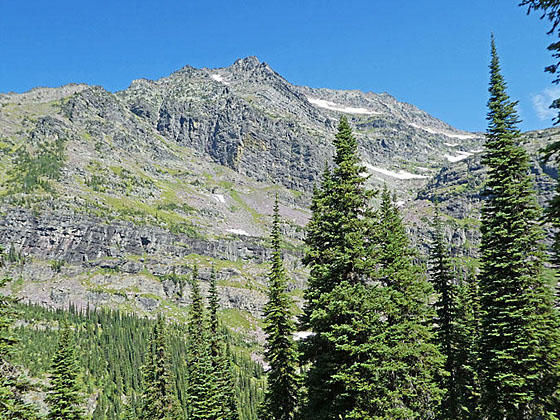
Beyond the junction the trail ascends through a forest of western hemlocks, red cedars and larches on moderately steep grades along the north side of the Snyder Creek drainage. Along the way are a few short, steep climbs. After a mile the path enters the area burnt by the Sprague Fire in 2017. The fire left a patchwork of trees with some areas burnt and others untouched. The result is a more open trail that offers better views of the surrounding area but is more exposed to the sun and therefore hotter.
As you climb, turn around in the open areas for good views of the Howe Ridge rising above the west side of Lake McDonald. After 1.5 miles the grade abates as the trail reaches the junction with the Mount Brown Trail, heading left (north). At 1.6 miles reach the junction with the Snyder Lake Trail branching left (northeast).
The trail now descends to and crosses Snyder Creek on a wood bridge. On the far side of the bridge the Snyder Ridge Trail branches right (south). Bear left to stay on the Gunsight Pass trail to the Sperry Chalet and Campground.
Past the junction the trail climbs on moderate grades through spruce-fir forest, crossing a low ridge into the Sprague Creek drainage at 2.1 miles. Here the grade abates as the trail now ascends along the north side of the Sprague Creek. After a short, steep climb at 2.9 miles the grade again moderates.
The grade steepens at 3.8 miles. After climbing a switchback at 4.0 miles the trees start to thin and give way to intermittent meadows. Soon views open to Medicine Bear Falls at 4.5 mile.
Beyond the falls the trail climbs on moderately-steep switchbacks. Here views open to the rugged cliffs and peaks rising above the trail. Soon you will see the Sperry Chalet perched on a high cliff to the right (east).
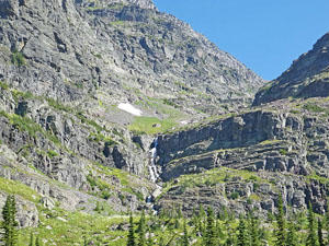
At 5.4 miles the massive cirque surrounding Glacier Basin comes into views. The cirque, anchored by Edwards Mountain (9,072-ft.) to the west and Peak 9,258 to the east, is truly stunning. Waterfalls spill down the cirque’s steep cliffs, watering the basin’s emerald green meadows.
Pass an unmarked junction with a trail branching left just before crossing the bridge over Sprague Creek at 5.7 miles. The trail now curves to the right and enters a copse of trees as it climbs on moderate to moderately-steep grades. Openings provide glimpses of more waterfalls tumbling down the basin’s rugged headwall.
Reach the junction with the Sperry Glacier Trail at 5.8 miles. Bear right to continue the ascent up switchbacks toward the Chalet and Campground. At 6.0 miles an overlook adjacent to the Sperry Chalet dining hall features terrific views of Edwards Mountain rising to the north. The chalet dormitory is at 6.2 miles and the campground at 6.5 miles.
The 2017 Sprague Fire consumed the Sperry Chalet Dormitory, built by the Great Northern Railway in 1913. Only the stone walls remained. The stone walls were stabilized and survived the winter of 2017-2018. A rebuilding project started in the summer of 2018 is expected to be completed by the end of 2019. Hopefully the dormitory will reopen for the 2020 summer season. In the meantime the dining room, which only suffered minor damage, will be open from 11:30am to 5pm during the rebuilding. Contact the Sperry Chalet for more information.
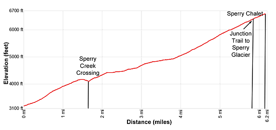
Elevation Profile
Driving Directions
From West Glacier, MT: From the junction of US-2 and the Going-to-the-Sun Road, turn northwest on the Going-to-the-Sun Road and follow the road 2.0 miles. Turn right at the junction with the Apgar Visitor Center to stay on the Going-to-the-Sun Road and continue along the road for 8.9 miles. A crosswalk across the road signals the beginning of the Gunsight Pass/Sperry Chalet Trail on the right (east).
Take the next left on an unmarked one-way road with a small wood building at the corner. Along this road you will find parking for the Lake McDonald Lodge and the trailhead. At the first intersection turn left on the road that runs parallel to the front of the Lodge. A short distance beyond take your next left on a one-way road heading back to the Going-to-the-Sun road. This road also includes parking for the Lake McDonald Lodge and the trailhead. Find a parking spot along the road and then walk the rest of the distance up the road to the Going-to-the-Sun Road. Carefully cross the Going-to-the-Sun Road using the crosswalk. The trailhead for the Gunsight Pass trail to the Sperry Chalet and Campground is on the east side of the road.
The parking lots around the Lake McDonald Lodge can be very congested. Typically in the morning, when people are checking out, you should be able to find a space. Alternative take the shuttle bus from the Apgar Visitor Center, a better option during the height of the summer when parking is limited.
Trail Resources
Trail Intro / Trail Photo Gallery / Trail Map
Basecamp(s) Information:
West Glacier
Region Information:
Glacier Natl Park, MT
Other Hiking Regions in:
Montana