Details: Kandersteg (Sunnbuel) to Adelboden 
Distance: 7.3 miles (one way)
Bernese Oberland, near Kandersteg in The Bernese Oberland
Hike Facts
- Distance: 7.3 miles (one way)
- Elevation: 6,352-ft. - 8,723-ft.
- Elevation Gain: 1,460-ft. - 2,959-ft.
- Difficulty: strenuous
- Trail Highlights: See Trail Intro
- Basecamp(s): Kandersteg
- Region: The Bernese Oberland
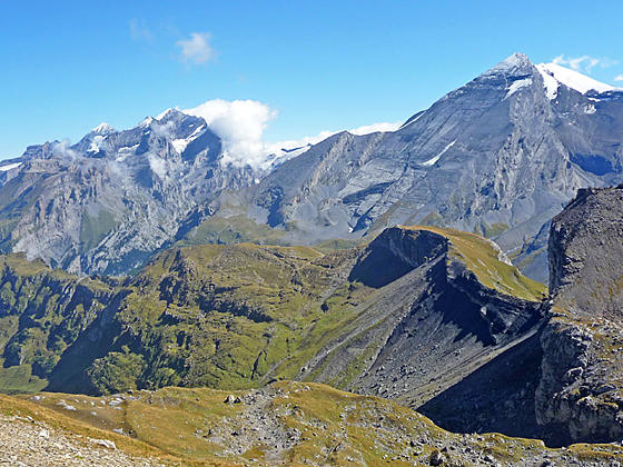
This challenging trail features panoramic views of the high peaks towering above the Spittelmatte, Uschene and Engstligenalp Valleys. The path is best suited for sure footed hikers who like demanding trails that cross exposed passes, travel along airy ridges and include steep ascents and descents.
Sunnbuel to Schwarzgratli Pass
Distance from Trailhead: 3.7 miles (one way)
Ending/Highest Elevation: 7,812-ft.
Elevation Gain: 1,460-ft.
Begin the day by riding the Kandersteg-Sunnbuel cable car to Sunnbuel. (See trailhead directions below.) At Sunnbuel find the trail signpost outside the station and walk southwest on a broad track through scattered trees toward Schwarenbach. The trees give way to pastures as the path descends on moderately easy grades to the Spittelmatte Valley floor.
Along the way enjoy views of Altels and the Rinderhorn towering above the valley to the east while the Uschenegrat, a high ridge, rims the valley to the west. Behind you the Doldenhorn fills the skyline above the intersection of the Kandertal and Gasterntal valleys to the northeast.
On the valley floor the trail travels through pastures on easy grades, reaching a junction at the Spittelmatte alp at 1.0 mile. Bear right on the main track heading up the valley (southwest) toward Schwarenbach.
The track now crosses a bridge over a tributary stream and then ascends on easy grades along the west side of the Schwarzbach stream. As you head up valley ignore any trails branch off the main track.
At 1.5 miles the grades steepens as the track ascends through a massive rockslide. The slide covers an area destroyed in September 1895 when part of the glacier along Altels western slopes broke off and crashed down the hillside, burying the valley floor in ice and debris.
At 2.25 miles the grade abates as the trail curves around a rocky slope, reaching the Hotel Schwarenbach at 2.5 miles. The hotel offers private rooms and dormitory accommodation along with a restaurant with views of the Daubenhorn and nearby peaks rising above valley. Below the hotel is a small lake.
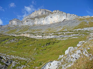
At the far (west) end of the hotel turn right on a narrow trail signed for Schwarzgratli and Engstligenalp. The path ascends steeply up the rocky hillside behind the hotel accompanied by fine views of the Felshore rising along the Uschenegrat ridge.
The path soon turns left and ascends through meadows and rock outcroppings along the east facing slopes of the Uschenegrat ridge. Behind you are great views of the Balmhorn, Altels and, in the distance, the Doldenhorn. The Rinderhorn massif towers above the valley to the east.
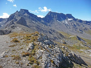
At 3.4 miles the grades eases as the trail crests a minor ridge and then ascends along the slopes of a bowl to a signed junction at Schwarzgratli, a pass atop of the Uschenegrat Ridge, at 3.7 miles. Here grand views open northwest to the Tschingellochtighorn and Gross Lohner rising above the Uschene Valley. Turn left at the junction toward Engstligenalp. (The trail to the right heads north along the Uschenegrat Ridge.)
After a brief stint along the ridge crest the trail turns right and descends on a steep, exposed, scree-covered trail traveling along a cliff face. Red and white slashes on the rock will keep you on track. This pass is only recommended for sure footed hikers. Anyone with a fear of heights or discomfort with exposure should not attempt the descent.
Note: If you are not comfortable descending from the Schwarzgratli, turn around and walk back along the ridge to the junction and then walk north along the ridge to the Wyssi Flue. The trail ascends to the summit and then travels along the west facing slopes of the Uschenegrat Ridge to a junction north of the Gallihorn. Here the trail to the left drops down to the Uschene Valley floor and then Kandersteg while the path to the right descends to the Spittelmatte Valley floor near the top station for the Sunnbuel cable car. Either take the cable car or walk back to Kandersteg.
Schwarzgratli Pass to Engstligengrat to Engstligenalp
Distance from Trailhead: 7.3 miles (one way)
Ending/Highest Elevation: 8,723-ft.
Elevation Gain: 2,959-ft.
Along the descent from Schwarzgratli Pass reach an intersection with a trail branching right toward the Uschenetal Valley. We continue straight ahead ascending toward Talli and Engstligenalp.
At 4.0 miles the descent ends and the trail now ascends through rocky meadows to a junction at 4.2 miles. The trail to the right drops down to the Uschenetal Valley. We bear left toward the Engstligengrat and Engstligenalp. Behind you are interesting views of the Doldenhorn and the summit of Altels.
Soon we reach a junction at the foot of Talli, a rugged hanging valley sandwiched between the Uschenegrat and Engstligengrat ridges. To the left a trail leads to the Talliseeli, Rot Chumme and Gemmi Pass. We bear right toward Engstligengrat and Engstligenalp on a path that crosses the valley floor and then climbs steeply through meadows and scree along the east facing slopes of the Engstligengrat ridge. Red and white slashes on rocks mark the trail.
Views along the climb stretch east/northeast to the Doldenhorn, Altels and the Rinderhorn. To the south Rote Totz, the Steghorn and Tierhori anchor the cirque at the head of the Talli valley while the Felshore rises to the southeast. The Talliseeli, a meltwater tarn, lies nestled in a rugged bowl below the trail to the south.
Crest the Engstligengrat ridge at 4.9 miles and turn right on the path signed for Engstlingenalp and Kandersteg. The ridge crest enjoys stunning views of the surrounding peaks. In addition of the summits seen on the hike so far, views now open to the cirque, anchored by the Steghorn, Grossstrubel and Ammertenspitz, rimming the Engstligenalp Valley, a large emerald green bowl. The peaks towering above Adelboden dominate the view to the northwest. On a clear day the ice-capped summits of the Weisshorn and Bishorn rise in the distance to the southeast.
The trail now ascends along the ridge toward the rugged summit block of the Tschingellochtighorn. The Gross Lohner massif rises beyond the ridge to the north. At 5.25 miles the trail crosses a minor summit and then follows the ridge as it curves to the left (northwest) toward the Tschingellochtighorn.
Descend on easy grades toward the base of the Tschingellochtighorn’s summit block and a junction at 5.4 miles. The trail branching right descends to the Uschenetal and then drops down to Kandersteg. Our trail bears left, traverse beneath the south side of the summit block and then descends very steep scree covered slopes to the Artelegrat Ridge. This section of the trail is exposed and should be avoided by anyone with a fear of heights. It should not be attempted if covered with snow or ice.
Reach the Artelegrat Ridge, extending west/northwest from the Tschingellochtighorn, at 5.6 miles. Here the footing improves but the trail continues its relentless drop down tight switchbacks. Along the way pass another trail, branching right, toward the Uschenetal and Kandersteg.
At 6.1 miles the scree gives way to meadows and the hike gets easier despite the continued steep descent. To the south enjoy fine views of peaks ringing the Engstligenalp valley and the summits towering above the Gils Valley, located to the south of Adelboden. The Gross Lohner dominates the views to the north.
Soon views open to Adelboden to the northwest. At 6.8 miles the grade abates as the trail turns left (south) and descend through pastures to a broad track at 7.2 miles. Turn right (north) and follow the track to the cable car station at Engstligenalp at 7.3 miles. Ride the cable car down to Unter dem Birg and then catch the bus back to Kandersteg or Adelboden. See the trailhead direction below for more information on transportation options.
Elevation Profile
Driving Directions
Note: It is possible to walk from Kandersteg to Sunnbuel. The hike adds 3 hours and 2,438-ft. in elevation gain to the day. I strongly recommend taking the cable car. To walk, hike south on the main road through Kandersteg to the Sunnbuel Cable Car Station. Continue on the road past the cable car station. Soon you will see a trail signed for Stock and Sunnbuel. Turn left and follow the trail that climbs steeply to Sunnbuel.
Kandersteg Bahnhof (Train Station) to Sunnbuel Cable Car:
Walking: From the front (east side) of the train station, walk south a short distance and turn left (east) onto Bahnhofstrasse (Train Station Street). Walk about 700-ft. east on Bahnhofstrasse, passing the Coop Supermarket along the way. When you hit the main road (Dorfstrasse) turn right. Follow the main road to the Luftseilbahn Kandersteg-Sunnbuel (Cable car – Kandersteg to Sunnbuel). The 1.6 mile walk should take about 30-40 minutes.
Bus: Take the #241 bus from the Kandersteg Bahnhof (train station) to the Talstation Luftseilbahn Sunnbuel (valley station) for the Sunnbuel Cable Car). The ride should take about 9 minutes. The bus makes a number of stop along the main road through the town. Check the SBB website or download the SBB app for the current schedule and to find the stop nearest to your accommodations.
Engstligenalp to Adelboden or the Kandersteg Bahnhof: Take the cable car from Engstligenalp to Unter dem Birg. Exit the cable car and cross the street to the bus stop. Take the #232 bus, which goes all the way to Adelboden. If you wish to return to Kandersteg, get off at Adelboden Oey. Here you need to change to the #230 bus bound for Kandersteg. Walk a short distance north up the road to an intersection, turn right and then walk a short distance to the #230 bus stop. It is very likely that other people will be making this change. If you are confused, ask and people will happily point you in the right direction. Most Swiss speak English.
Parties heading to Kandersteg now have two options. You can stay on the #230 bus all the way to Kandersteg or get off the bus at the Frutigen Train Station and take the train to Kandersteg. The train is faster by 12 minutes. The bus is easier, since you don’t have to change. Check the SBB website or download the SBB app for the current schedule. The ride back to Kandersteg takes between one-hour 52-minutes to two hours 4-minutes.
Trail Resources
Trail Intro / Trail Photo Gallery / Trail Map
Basecamp(s) Information:
Kandersteg
Region Information:
The Bernese Oberland
Other Hiking Regions in:
Switzerland