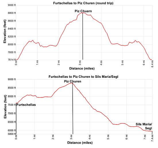
Details: Lej Sgrischus to Piz Chuern 
Distance: 6.4 - 7.6 miles (round trip)
near St Moritz in Eastern Switzerland
Hike Facts
- Distance: 6.4 - 7.6 miles (round trip)
- Elevation: 7,589-ft. - 8,806-ft.
- Elevation Gain: 1,460-ft.
- Difficulty: moderate
- Trail Highlights: See Trail Intro
- Basecamp(s): St Moritz
- Region: Eastern Switzerland
Skip the crowds on this great hike that travels through Alp Munt, visits lovely Lake Sgrischus and then climbs to a panoramic overlook atop Piz Chuern with views of the Corvatsch massif and the high peaks towering above the Fex, Fedoz and Upper Engadine valleys.
Furtschellas to Lej Sgrischus to Piz Chuern

Note: Piz in Romansh, a language spoken by some in the Swiss Engadine, means peak and lej means lake. So Piz Corvatsch is Corvatsch Peak and Lej Segl is Lake Segl, or in German the Silsersee. On trail signs you will often see two different names (one in Romansh and one in German) or different spellings for a destination. For example Sils: German and Segl: Romansh.
From Sils/Segl Maria, take the Furtschellas cable car to the middle station. (See trailhead directions below.) Outside the station find the trail signpost and starting ascending on moderate to moderately-steep switchbacks through rocky meadows toward Alp Munt, Lej Sgrischus and Piz Chuern. At all intersections continue toward Alp Munt and Lej Sgrischus. As you ascend enjoy great views extending west/northwest to the high peaks rising above Lake Sils (Silsersee/ Lej da Segl) and Lake Silvaplana (Silvaplanersee/Lej Silvaplauna). The Piz Julier massif and nearby summits dominate the view to the north.
At 0.6 miles the grade abates as the trail passes an intersection where the Wasserweg trail turns left. We bear right, curving around the end of a ridge extending west from the Piz Corvatsch massif.
At 0.8 mile reach a high point on the ridge. The undulating path now curves to the south/southeast around the ridge, descending through meadows scattered with rocky knolls high above the east side of Val Fex. Ahead views open to the ridge separating the Fex and Fedoz Valleys. Piz Salatschina, Piz Led, Piz Guz and Piz Flora punctuate the ridge while Piz da la Margna and Piz Fedoz rise along the ridge above the west side of Val Fedoz. Soon the summits at the head of the Fex Valley, Il Chaputschin and Piz Tremoggia join the scene.
At 1.0 mile pass a junction with a trail branching left and ascending steeply to Grialetsch and Lej Sgrischus. (This is a longer, steeper and more rugged route to the lake.) We continue straight ahead toward Alp Munt and Leg Sgrischus.
A short, steep decent followed by an undulating path through meadows leads to a junction at the north end of Alp Munt at 1.5 miles. Here a trail branching northwest descends to Marmore and Sils/Segl Maria. (Hikers wishing to walk up instead of taking the cable car will join the trail to Lej Sgrischus here.) We continue through the rocky pastures of Alp Munt, passing the building at Munt Sura at 1.7 miles. Ahead are fine views of Piz Chuern and Il Chaputschin. A waterfall tumbles down the steep slopes at the head of the Alp.
Reach a junction and the south end of Alp Munt at 2.0 miles. The trail to the right drops down the east side of Fex Valley toward Sils/Segl Maria. We bear left on the trail to Lej Sgrischus that climbs switchbacks up a steep hillside beside a stream. Take a break as you climb to enjoy the great views of Lake Sils and the high peaks rimming the northwest side of the Upper Engadine Valley.
Soon the trail crosses the stream and views open to a pond nestled beneath rugged cliffs of Piz Chuern. This is not Lej Sgrischus. Continue climbing up the steep slopes to the north of the tarn.
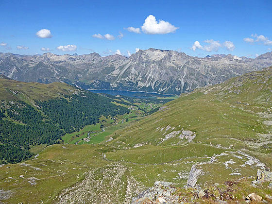
At 2.4 miles the grade abates a bit and soon passes the other end of the Grialetsch trail. Beyond the junction the path ascends to a bench and reaches the north end of Lej Sgrischus at 2.6 miles. The lake lies cradled in meadows beneath Piz Corvatsch and the Crasta dal Lej-Sgrischus (Lake Sgrischus ridge). Views stretch south/southeast across the lake to Il Chaputschin and Piz Fora. Piz Chuern is seen to the southwest.
Cross the lake’s outlet stream and arrive at a signed junction with a trail heading southwest toward Piz Chuern, Val Fex and Sils/Segl Maria. Initially the trail ascends on easy grades above the lake’s western shore. Ahead are views of the cirque at the head of the Fex valley and the summits rising above Lake Sils. Near the south end of the lake the grades steepens as the trail swings to the west and climbs to the broad, meadow-clad summit of Piz Chuern (8,806-ft.) at 3.2 miles.
From the summit panoramic views encompass the rugged peaks towering above Lake Sils and the Upper Engadine Valley. The summits rising above the Fez and Fedoz valleys dominate the view to the west while the cirque at the head of Val Fez fills the skyline to the southwest. Behind us, to the southeast, the rugged Piz Corvatsch massif towers above Lake Sgrischus. Below our birds-eye-roost are the emerald green meadows of Val Fez.
From Piz Chuern you have two choices for the return. The easiest option is to retrace your steps the Furtschellas cable car and take the lift down to Sils/Segl Maria. Alternatively, follow the trail dropping off the west side of Piz Chuern toward Sils/Segl Maria. The path descends steeply down the peak’s west facing flanks and then curves to the northwest at 3.6 miles, continuing its descent through meadows high above the east side of Val Fex.
After crossing two streams the grade moderates at 4.4 miles. At 4.7 the descent again steepens as the path drops down to a junction at 5.1 miles. Here you have two choices. Turn left (up valley) on a trail that angles down to the valley floor (longer and less steep) or continue straight head on the path that descend tight, steep switchback to the valley floor.
Take the latter option and reach the valley floor at 5.5 miles. Turn right and head down valley on easy grades following the signs back to Sils/Segl Maria post. Along the way pass the villages of Fez-Crasta and Fez-Platta where you can find refreshments. Reach Sils/Segl Maria post at 7.6 miles after losing 2,871-ft. in elevation. Here you can catch a bus back to St. Moritz.
Elevation Profile
Driving Directions
From the St. Moritz Bahnhof (train station) to Furtschellasbahn (Furtschellas Cable Car): At the St. Moritz Train Station board a #6 bus heading toward Corvatschbahn. Get off at Silvaplana Kreisel Mitte and change to the #6 bus to Sils/Segl Maria, Furtschellasbahn. Ride the Furtschellas Cable Car to the Mittelstation (middle station) where the hike starts.
Get bus information from the local tourist office, visit the Engadine Bus Routes page or go to SBB website/ SBB app to find the closest stop to your accommodations. Check the Current News section of the Corvatsch-Furtschellas website for a current Sils/Segl to Furtschellas cable car schedule and prices.
Hikers preferring to walk instead of taking the Furtschellas cable car should take the #6 bus to Sils Maria Post and then follow signs to Marmore and Alp Munt. Walking from Sils/Segl Maria will add over 1,500-ft. and 2.2 miles (one-way) to the day.
Trail Resources
Trail Intro / Trail Photo Gallery / Trail Map
Basecamp(s) Information:
St Moritz
Region Information:
Eastern Switzerland
Other Hiking Regions in:
Switzerland