Details: Moon House Ruin 
Distance: 3.2 - 5.6 miles (round trip)
BLM, Monticello, Utah office, near Blanding in Southeast Utah
By: Diane Greer
Hike Facts
- Distance: 3.2 - 5.6 miles (round trip)
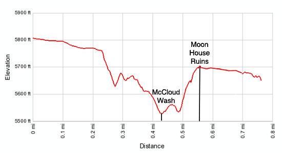
- Elevation: 5,815-ft. - 5,680-ft.
- Elevation Gain: -135-ft.
- Difficulty: moderate
- Trail Highlights: See Trail Intro
- Basecamp(s): Blanding
- Region: Southeast Utah
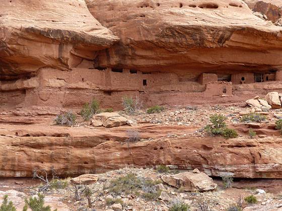
Moon House, one of the best archaeology sites on Cedar Mesa, consists of three separate structures with 49 rooms. Well preserved pictorgraphs grace the walls of an interior courtyard and some of the rooms.
To Moon House Ruins
The trailhead for Moon House ruins is located down the Snow Flat Road, which is 6.2 miles south of the Kane Gulch Ranger Station on UT 261. If starting the hike from the two wheel drive parking area cross the Snow Flat Road and head north on the unmarked dirt road across from the parking lot. Walk along the sandy road for 1.2 miles to the 4WD parking area.
Note: If starting the hike from the 2WD parking area the round trip distance for the hike is 5.6 miles. From the 4WD parking area the round trip distance is 3.2 miles.
The trail to Moon House heads east/northeast through pinyon pine, junipers and desert scrub for 0.2 miles to the rim of McCloyd Canyon. At the rim a cairned route drops down a series of steep switchbacks to a slickrock ledge, 150-ft. below the rim. The trail now turns north, traveling along the ledge.
Look across the canyon as you proceed along the ledge. About three-quarters of the way up the far wall you will see alcoves with ruins. Near the end of the ledge traverse views open to a long line of ruins sheltered in a huge alcove, this is Moon House.
At the end of the ledge the trail turns east/northeast and zigzags steeply down an old rockslide to the canyon floor, losing over 100-ft. The trail reaches the canyon floor by some huge boulders. Make note of the location so you can find the trail out of the canyon on the return leg of the hike.
Turn right (southeast) and head down canyon for about 100 yards, watching for rock cairns marking the trail climbing up the northeast canyon wall to the ruins. Follow the cairned trail as it ascends slickrock slopes and a series of ledges to the Moon House ruins, gaining over 160-ft. In one spot you may need to use your hands.
Moon House ruins consist of three cliff dwellings spread out along a 0.25 mile section of the ledge. With 49 rooms the ruins are one of the largest prehistoric dwellings on Cedar Mesa. It is also one of the most fragile, so please be very careful during your visit. Do not touch the rock art or step, sit or climb atop the ruins. This is truly an incredible site. Treat it with reverence and respect. What you are looking at is both priceless and irreplaceable. Please see the BLM document explaining the etiquette in visiting archaeology ruins for more information.
Tree ring cores of the juniper and pinyon logs used to construct the site indicate a 42-year construction span, between 1226 and 1268 AD, with three peak building periods. Archaeologist estimate that during the late period of occupation 30 of the habitation and storage room were in use. This would translate into 25-35 people living at the site.
If you look at the main section of ruins you will see two different construction techniques. Some of the structures (on the right) are constructed of horizontal and vertical wood poles, lashed together with willow or yucca strips. The wood lattice is then covered with mud. This so called jacal technique was used to build the earliest structures in the ruins. Many of these ruins have horse-collar shaped doorways.
The main part of the cliff dwelling (on the left) is composed of shaped sandstone blocks. Small stones are placed in the mortar between the blocks. This decorative style is employed on the later structures at Moon House.
The long wall on the left side of the ruins contains 27 holes, referred to a loop holes. Be sure to look through the holes after you enter the main part of the ruins. These holes provide line of sight coverage of all angles of the canyon access and a portion of the canyon floor. Some believe these holes served a defensive function.
One interesting aspect of the ruin is the long wall with loop holes creates an inner courtyard. Carefully enter the main structure and you will see a series of rooms along the back of the alcove opening onto the inner courtyard. Rock art decorates the interior walls of the courtyard and the some of the rooms. Soot covers the ceiling.
The ruin gets its name from a room that is decorated with the moon’s phases in negative relief. The BLM has lined the floor of this structure with four inches of desiccant sand to absorb the water vapor from visitor’s breath that may cause the paint on the walls to peel.
As you continue to explore the main ruin you wills start to see more rock art, some of it quite faint, decorating the walls of the courtyard. After you exit the main structures walk left (northwest) along the ledge to see more rock art and additional structures. One notable rock art panel depicts what looks like a snake. Pass between the canyon wall and a huge rock obelisk for views up the canyon to the north. If you look carefully you will see a few more structures located in alcoves in the canyon’s walls to the north.
It is also possible to follow the ledge as it heads southeast and the curves to the east. Along the way you will pass some isolated structures and two more cliff dwellings tucked in alcoves along the ledge. This section of the ledge enjoys nice views down the canyon to the southeast.
After investigating the ruins along the ledge return to the main Moon House ruins for one last look. If you have time it is possible to walk up and down the canyon to see more ruins. In both directions you will hit waterfalls/dryfalls that will impede/prohibit further progress. After exploring the area retrace your steps and climb out of the canyon.
Permits: Entry into the Moon House site requires a special permit available only at the Kane Gulch Ranger Station, during the high-use seasons March 1st - June 15th and September 1st - October 31st. Permits are currently limited to 20 people per day and subject to availability. Permits may be reserved in advance by calling the Cedar Mesa Permit Office or obtained in person at the Kane Gulch Ranger Station on the day of your trip (see below). All permits, including those reserved in advance, must be picked up in person at the Kane Gulch Ranger Station on the day of your trip, between 8:00 AM and noon.
During the low use seasons, winter (November 1st - February 28th) and summer (June 16th - August 31st), self-pay envelopes and registration forms are available at the trailheads. Permit fee is $2 per person
Advance reservations for Moon House day use permits are available 3 months prior to your trip date and no later than 2 days before your trip date. They may be obtained by calling the Cedar Mesa Permit Office at (435) 587-1510, between 8:00 AM and noon (MDT) Monday through Friday.
Walk-in permits for Moon House day use permits are available daily and must be obtained at the Kane Gulch Ranger Station during the high use seasons March 1st - June 15th and September 1st - October 31st. During the low use seasons (November 1st - February 28th and June 16th - August 31st), self-pay envelopes and registration forms are available at the trailheads.
Check the Recreation.gov website for the latest permit information.
Elevation Profile
Driving Directions
From Blanding: Drive south on US 191 S for 4 miles and turn right (west) on UT-95 N. Follow UT-95 for 28.4 miles and turn left (south) on UT-261 S. Head south on UT 261 for 10.1 miles and turn left (southeast) on the Snow Flat Road, located between mile posts 22 and 23. The turn is 6.2 miles south of the Kane Gulch Ranger Station. There is a BLM sign setback from the highway marking the Snow Flat Road. Follow the dirt road (County Road 237) for 8.2 miles to the two-wheel drive trailhead on the right (west) side of the road, marked by a kiosk. (Two wheel drive vehicles can make the trip if they have good clearance.) Four wheel drive vehicles can turn left (north) on the unmarked dirt road across from the parking area and drive for 1.2 miles to a parking area. The road is rough in places and has a very high center. Avoid the Snow Flat Road during wet conditions.
From Mexican Hat: Head north on US-163 for 3.9 miles and turn left (north) on UT-261 N. Follow UT-261 north for 22.6 miles and turn right (southeast) on the Snow Flat Road, located between mile posts 23 and 22. There is a BLM sign setback from the highway marking the Snow Flat Road. Follow the dirt road (County Road 237) for 8.2 miles to the two-wheel trailhead on the right (west) side of the road, marked by a kiosk. (Two wheel drive vehicles can make the trip if they have good clearance.) Four wheel drive vehicles can turn left (north) on the unmarked dirt road across from the parking area and drive for 1.2 miles to a parking area. The road is rough in places and has a very high center. Avoid the Snow Flat Road during wet conditions. Note: a short section of UT-261 climbs steep gravel switchback up the Moki Dugway.
Trail Resources
Trail Intro / Trail Photo Gallery / Trail Map
Basecamp(s) Information:
Blanding
Region Information:
Southeast Utah
Other Hiking Regions in:
Utah