Details: Mule Canyon, South Fork 
Distance: 2.0 - 9.2 miles (round trip)
BLM, Monticello, Utah office, near Blanding in Southeast Utah
By: Diane Greer
Hike Facts
- Distance: 2.0 - 9.2 miles (round trip)
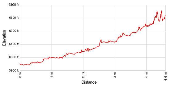
- Elevation: 5,940-ft. - 6,290-ft.
- Elevation Gain: 55-ft. - 450-ft.
- Difficulty: easy-moderate
- Trail Highlights: See Trail Intro
- Basecamp(s): Blanding
- Region: Southeast Utah
This easy hike offers an excellent opportunity to discover well preserved ruins tucked into alcoves and along the walls of side canyons in the scenic South Fork of Mule Canyon.
Trailhead to House On Fire
Distance from Trailhead: 2.0 miles (round trip)
Ending/Highest Elevation: 5,995-ft.
Elevation Gain: 55-ft.
This hike starts off of County Road 263 / Texas Flat Road, a spur road off UT-95 that is a little over 23 miles from Blanding, UT. (See the driving directions below.)
From the pullouts, located on the south side of the road, cross to the north side of the road a find a trail dropping into the South Fork of Mule Canyon, passing a trail register along the way. The well defined trail heads northwest and then west up the wide shallow canyon on a grassy bench, passing through desert scrub, pinyon pines and junipers. Cottonwoods and willows are scattered along the floor in the wetter sections of the drainage.
Initially the canyon’s walls, composed of alternating layers of red and white sandstone, are only 80-ft. high but will rise to heights of 500-ft. toward the upper reaches of the canyon, about 5 miles from the trailhead.
The easy trail up the lower and middle sections of the canyon alternates between walking in the wash and its adjacent benches. Hiking in the upper end of the canyon is more challenging. Here the canyon becomes steeper. Boulders and ponderosa pines frequently choke the narrow canyon floor.
The South Fork of Mule Canyon is a great place to explore and discover Anaszai ruins. Remember that the Anasazi favored building their dwellings in south facing alcoves warmed by the winter sun. As you proceed up canyon look for alcoves along on the canyon’s north wall that may shelter ruins. Bring a pair of binoculars to facilitate your search.
Remember to treat all the archaeology you discover with respect so that it may be enjoyed by future generations. These structures are over 700 years old and are VERY fragile and easily damaged.
When visiting a site never climb, sit or walk on the walls and do not enter the rooms. Do not touch the rock art. Oils from your hands can cause the paint to flake from the walls. Stay out of the middens, essentially the prehistoric trash mounds, typically located immediately down slope of an alcove or cliff site. Leave any pot shards, corn cobs or other relic where you found them.
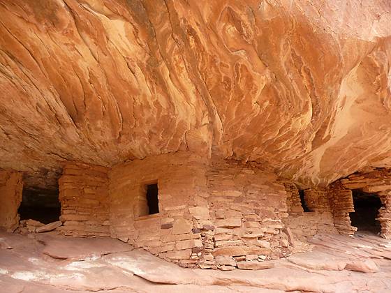
The first set of ruins is located just under a mile from the trailhead where the canyon curves to the left (west). Trees growing along the wash partially obstruct the view of the ruins, making it easy to walk right by the site. The ruins, which consist of about five rooms, are frequently referred to as the House on Fire because patterns in the alcove’s red and white sandstone ceiling look like flames shooting from the roofs of the structures.
To the Viewpoint for Last Set of Ruins
Distance from Trailhead: 9.2 miles (round trip)
Ending/Highest Elevation: 6,290-ft.
Elevation Gain: 450-ft.
Find the next set of ruins a little over 2 miles from the trailhead in a good size alcove, easily seen from the wash. The ruins consist of one room and the walls of at least one other adjoining structure.
The canyon is now getting noticeably deeper and more scenic with the walls decorated with desert varnish. Desert varnish, the thin red to black coating found on the exposed rock surfaces of the canyon, is composed of clay minerals, oxides and hydroxides of manganese and/or iron, as well as other particles. Its color depends upon the relative amounts of manganese and iron. Manganese-rich varnishes are black; manganese-poor, iron-rich varnishes are red to orange; those intermediate in composition are usually a shade of brown.
At 2.5 miles bypass a large pool in the wash on the right (north) by following a route marked with rock cairns along a wide slickrock bench. A short distance beyond the bypass, look for ruins located in two alcoves along the canyon’s north wall. The deep alcove on the right (north) contains a low wall set in front of several well preserved structures. To the left is a shallow alcove with two smaller ruins. Notice the soot marks on the ceilings of the alcoves, mostly likely caused by fires used for cooking and warmth.
Views of the next ruin, located at 2.9 mile, are partially blocked by trees growing on the bench to the north of the wash. The alcove, located beneath a pour-off, looks like it contains a kiva. With binoculars you should be able to see what appear to be roof beams atop the structure.
Beyond the ruins the canyon curves to the left (west). At 3.2 miles a bypass trail climbs steeply up the bench to the left (south) of the wash to circumvent a low pour-off and plunge pool. Make note of where this detour reenters the wash so you do not miss the bypass on the return leg of the hike.
The trail now turns north and passes a small side canyon. A short distance past the side canyon look for ruins sheltered by a large overhang, decorated with desert varnish, along the right (north) wall of the canyon. The ruins, located at 3.5 miles, are partially hidden by junipers and pine growing just below the alcove. A set of binoculars will help you locate the ruins, just to the left of a wide black strip of varnish.
The walls of the canyon are now noticeably higher and quite scenic. Keep an eye open for a sculpted V-shaped section of sandstone jutting from the upper section of the north wall. Depending on where you are standing the formation looks like a large set of angel wings.
At 3.7 miles a side canyon opens to the right (north). At this point you have a choice, either turn around a retrace your steps to the trailhead for a 7.4 miles round-trip hike or continue up canyon.
Hikers continuing up canyon will need to detour around a minor pour-off and plunge pool. Just beyond the side canyon find a trail climbing the slickrock bench to the right (north) of the plunge pool.
About a quarter mile past the side canyon look for a large alcove high on the north wall. With binoculars you should be able to spot a ruin. The ruins are located to the left of some shrubs and a small pine tree growing just below the alcove.
As you continue up canyon boulders and ponderosa pines crowd the wash making the walking a little more challenging. About a half mile past the side canyon find another side canyon opening to the right (north). There are a number of ruins located under a huge alcove along the side canyon’s east wall, just above the confluence. Thick foliage in the wash makes it difficult to see these ruins.
At this point you have walked 4.75 miles, including the side trips. This is a good turnaround point for the day hike. As you return to the trailhead look for alcoves with ruins you might have missed on the walk up the canyon. Total round trip distance for the hike to the second side canyon is 9.2 miles.
Elevation Profile
Driving Directions
From Blanding: Drive south on US 191 S for 4 miles and turn right (west) on UT-95 N. Follow UT-95 for 19.4 miles and turn right (north) on County Road 263 / Texas Flat Road, located between mile posts 103 and 102. Drive northeast on the dirt road for 0.3 miles and park where the road crosses the first canyon. There are pullouts along the right (south) side of the road for a few cars. More parking spaces are located further up the road. Note: The road becomes impassable during wet conditions.
Trail Resources
Trail Intro / Trail Photo Gallery / Trail Map
Basecamp(s) Information:
Blanding
Region Information:
Southeast Utah
Other Hiking Regions in:
Utah