Details: First Fork of Slickhorn Canyon 
Distance: 4.9 - 9.0 miles (round trip)
BLM, Monticello, Utah office, near Blanding in Southeast Utah
Hike Facts
- Distance: 4.9 - 9.0 miles (round trip)
- Elevation: 6,120-ft. - 5,430-ft.
- Elevation Gain: -690-ft.
- Difficulty: moderate-strenuous
- Trail Highlights: See Trail Intro
- Basecamp(s): Blanding
- Region: Southeast Utah
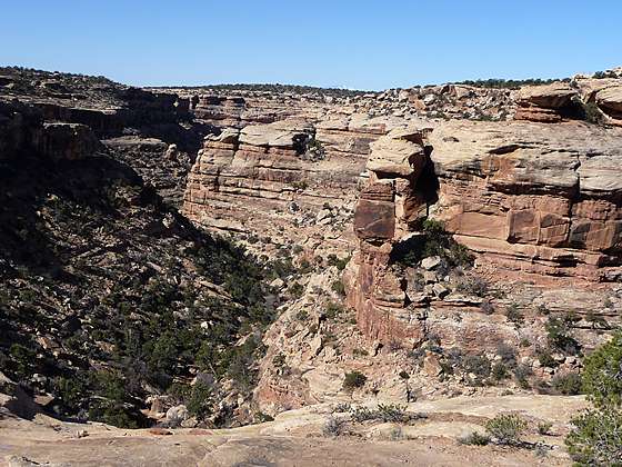
Hikers making the very steep descent into the rugged, scenic First Fork of Slickhorn Canyon are rewarded with the opportunity to visit Perfect Kiva, one of the few kivas on Cedar Mesa that hikers are permitted to enter.
To Perfect Kiva
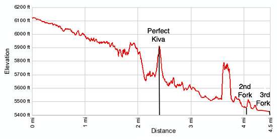
Distance from Trailhead: 4.9 miles (round trip)
Ending/Highest Elevation: 5,630-ft.
Elevation Gain: -490-ft.
(Note all mileage includes side trips to visit ruins and rock art.)
The trailhead for the First Fork of Slickhorn Canyon is located down a spur road off of UT-261, 9.7 miles south of the Kane Gulch Ranger Station. (See driving directions below.) From the park area the trail heads southwest down the wash of the First Fork Slickhorn Canyon on easy grades. After walking about a half mile a small pour-off is bypassed on a path along the left (south) side of the canyon. As you descend the drainage, keep an eye out for granaries tucked in small alcoves along the canyon’s north wall.
At 1.7 miles reach a large pour-off. To bypass this obstacle follow the trail marked with rock cairns ascending along the left (south) side of the canyon. The trail climbs slickrock slopes and then traverses along a bench. From the bench enjoy fine views into the canyon. Look back at the short side canyon branching to the north of the pour-off to see a ruin nestled in a small alcove.
As you travel along the bench note the rock spire rising along the wall across the canyon. The trail descending into the canyon will reach the canyon floor just below the spire.
At 2.0 miles watch for the cairned route that switchbacks steeply down the canyon wall to the wash, losing 250-ft. in 0.2 miles. (Backpacker may want to use ropes to drop packs down particularly steep sections of the trail.) As you descend look west across the canyon. On the north wall is a large alcove containing the ruins known as Perfect Kiva. (This site is not to be confused the Perfect Kiva in Bullet Canyon.)
Upon reaching the canyon floor navigate through a section of boulders and then follow a boot beaten path down canyon for about 300 yards. Keep an eye out for a use trail, marked by cairns, ascending steeply up the canyon’s right (north) wall. This trail leads to the alcove and Perfect Kiva.
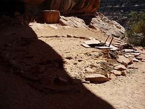
The detour to Perfect Kiva is definitely worth the time and energy. The trail climbs up very steep, rocky slopes to the large alcove sheltering the kiva. Perfect Kiva, estimated to be over 700 years old, is in amazing condition with its original roof fully intact. Only the ladder has been replaced with a replica. (The original is at the Edge of the Cedars Museum in Blanding.) The alcove also contains storage bins, a granary and the remains of a few other structures, some in quite good condition.
Please be very careful while visiting Perfect Kiva. Treat all the archaeology you discover with reverence and respect so that it may be enjoyed by future generations. The BLM allows hikers to climb down the ladder and into enter Perfect Kiva. When exploring the alcove please avoid walking on the Kiva’s roof. Do not sit, climb or step on the walls of any structures or attempt to enter any of the other structures. Leave any pot shards, corn cobs or other relic where you found them. See the BLM Guide on Visiting Archaeology Sites for more information.
To Third Fork of Slickhorn Canyon
Distance from Trailhead: 9.0 miles (round trip)
Ending/Highest Elevation: 5,430-ft.
Elevation Gain: -690-ft.
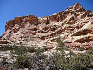
When you are done exploring Perfect Kiva retrace your steps to the canyon floor and continue walking down the First Fork of Slickhorn Canyon. The easy walk, alternating between the wash and it adjacent benches, is quite scenic with multi-hued sandstone walls sculpted by wind and water towering over 350-ft. above the canyon floor. As you proceed down canyon the walls will grow in stature.
After walking a little over 3.5 miles the trail climbs out of the wash and traverses a grassy bench along the right (west/northwest) side of the wash. Ahead you will see an east/southeast facing alcove. The alcove, mid-way up the wall, is located at a point where the canyon makes a prominent curve to the south. Here you will find some ruins and a few pictographs. One of the images depicting a human-like figure is painted with a green pigment.
At 3.9 miles views open to a balanced rock along the canyon’s right (west/northwest) wall. As you come abreast of the balanced rock the canyon opens and you reach the confluence with the Second Fork of Slickhorn Canyon, branching to the left (north/northeast) at 4.1 miles. Across from the confluence is a well preserved granary tucked in a small alcove near the base of the right (west/northwest) wall beneath the balanced rock. Backpacker will also find campsites around the confluence of the Second Fork.
If time and energy permit continue down canyon for 0.4 miles to the confluence of the Third Fork of Slickhorn Canyon, branching to the east. Here the canyon makes a sharp turn to the right (west). Just before the turn look for a small rock art site with an image of what looks like a duck, outlined in red.
This is a good point to turn around and retrace your steps back to your vehicle. Alternatively, turn left and walk 3.7 miles up the Third Fork of Slickhorn Canyon to the road. Upon reaching the road turn left (north) and walk 2.9 miles on the road back to your vehicle parked at the First Fork trailhead. Total distance for the loop hike is 11.1 miles. See the Third Fork to Trail Fork hiking description for more information on hiking up the Third Fork of Sickhorn Canyon.
Elevation Profile
Driving Directions
From Blanding: Drive south on US 191 S for 4 miles and turn right (west) on UT-95 N. Follow UT-95 for 28.4 miles and turn left (south) on UT-261 S. Head south on UT 261 for 13.6 miles and turn right (west) on County Road #245/Slickhorn Road, a dirt road located between mile posts 20 and 19. (The turn is directly across from the Cigarette Springs Road/County Road #239 and 9.7 miles south of the Kane Gulch Ranger Station.) Follow CR #245 for 2.6 miles to a “Y” intersection and bear left (south) on County Road #203/Point Lookout Road toward Slickhorn Canyon. The right fork leads to the Government Trailhead for Grand Gulch. Drive 1.6 miles on CR #203 and turn right onto an unmarked dirt road. Follow the road for a short distance (~0.4 miles) to a parking area. This is the trailhead for the First Fork.
From Mexican Hat: Head north on US-163 for 3.9 miles and turn left (north) on UT-261 N. Follow UT-261 north for 19.1 miles and turn left (west) on County Road #245/Slickhorn Road, a dirt road located between mile posts 19 and 20. (The turn is directly across from the Cigarette Springs Road/County Road #239 and 9.7 miles south of the Kane Gulch Ranger Station.) Follow CR #245 for 2.6 miles to a “Y” intersection and bear left (south) on County Road #203/Point Lookout Road toward Slickhorn Canyon. The right fork leads to the Government Trailhead for Grand Gulch. Drive 1.6 miles on CR #203 and turn right onto an unmarked dirt road. Follow the road for a short distance (~0.4 miles) to a parking area. This is the trailhead for the First Fork. Note: a short section of UT-261 climbs steep gravel switchbacks up the Moki Dugway.
Trail Resources
Trail Intro / Trail Photo Gallery / Trail Map
Basecamp(s) Information:
Blanding
Region Information:
Southeast Utah
Other Hiking Regions in:
Utah