Backpack: Cook - Island Lakes Loop
Segment 1: Elkhart Park to Cook Lakes Junction
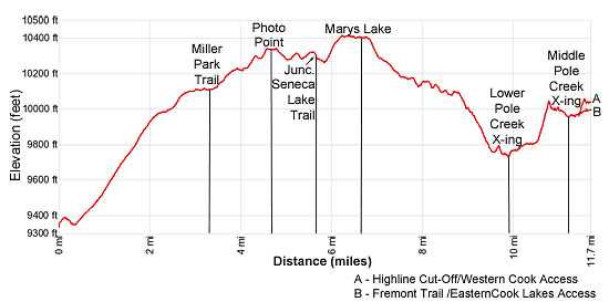
Distance: 11.7 miles (one way)
Bridger Wilderness, Bridger-Teton National Forest, near Elkhart Park in Wyoming's Wind River Range
By: Diane Greer
Fremont Peak, Mount Helen, Mount Woodrow Wilson and other summits to the north
- Distance: 11.7 miles
- Elevation: 9,340-ft. at Elkhart Park Trailhead
10,090-ft. at Junction Miller Lake Trail
10,350-ft. at Photographers Point
10,300-ft. at Junction Seneca Lake Trail
10,400-ft at Marys Lake
9,730-ft. at Lower Pole Creek Crossing
10,040-ft. at ridge above Pole Creek Lakes
9,960-ft. at middle Pole Creek Crossing
10,060-ft. at Junction Highline/Fremont Trails (Cook Lakes East Access)
10,020-ft. at Junction Highline/Cook Lakes West - Difficulty: moderate-strenuous
- Basecamp: Elkhart Park
- Region: Wyoming's Wind River Range
Elkhart Park to Cook Lakes Junction Description
The Pole Creek Trail, in conjunction with a segment of the Highline trail, offers an efficient and scenic way to reach the Cook Lakes, Bald Mountain Basin and points beyond. The trails are also used to create an interesting loop hike that explores the Cook Lakes, crosses panoramic Lester Pass, visits the stunning Island Lake area and then returns to the trailhead via the Seneca Lake and Pole Creek trails.
The Pole Creek Trail (#119) starts at the northeast end of the large parking lot at the Elkhart Park trailhead between the outhouse and trailhead kiosk. (See driving directions for the trailhead.) The trail immediately plunges into forest and briefly ascends north on easy grades. Soon the path curves to the right (southeast) and continues climbing on easy to moderate grades through trees along the southwest side of the Faler Creek Valley. Views occasionally open to willow-choked meadows along the valley floor. Twice I have seen Moose grazing among the willows. As you ascend the trail gets rockier and can be quite muddy after it rains.
At 1.7 miles the trail curves to the left (northeast) and ascends on moderate grades through spruce-pine forest. The grade eases as 2.1 miles and enters the Bridge Wilderness at 2.3 miles. Beyond the wilderness boundary the trail resumes climbing and curves to the right (east) at 2.7 miles.
Soon the grade eases as the trail traverses the meadows of Miller Park, passing the junction with the Miller Lake trail at 3.3 miles. Here we get a preview of coming attractions with distant views of the high peaks in the northern portion of the Wind River Range.
At the edge of the second meadow the trail turns to the left (north/northeast) and briefly ascends on moderate to easy grades through trees and then a third meadow with views to the north of Mount Helen (13,620-ft.), Mount Sacagawea (13,569-ft.) and Fremont Peak (13,945-ft.).
The landscape changes as the trail exits the meadows. The path now climbs on moderate grades through forest and small meadows set amid rock outcropping and granite knobs. At 4.1 miles the path turns to the left (north), passing a few small ponds nestled amid boggy meadows.
Reach Photographer’s Point at 4.6 miles. From the aptly named viewpoint a stunning panorama of high peaks fills the skyline to the north. Visible summits include Bow Mountain (13,020-ft.), American Legion Peak (13,205-ft.), Mt. Woodrow Wilson (13,502-ft.), Mount Helen, Mount Sacagawea, Fremont Peak and Jackson Peak. Below the viewpoint is the deep canyon carved by Fremont Creek. Look carefully and you will see the south end of Gorge Lake on the canyon floor. In the mid-distance are a sea of granite knobs and low peaks.
Past Photographer’s Point the trail descends to the southeast and then turns left (east), climbing over two low rises separated by a meadow. In the meadow pass the junction with the Sweeny Creek Trail branching to the right (south) at 5.3 miles.
Pole Creek Trail to Pole Creek Lakes
Reach the junction with the Seneca Lake Trail at 5.6 miles. Here the Seneca Lake trail branches to the left (northwest) toward the Seneca Lakes and Island Lake. We turn right (southeast) on the Pole Creek trail which drops down to and then traverses the western shore of Eklund Lake (10,260-ft.). At the south end of the lake the trail climbs switchbacks on moderate grades to the Top Lakes, gaining about 160-ft. in 0.35 miles.
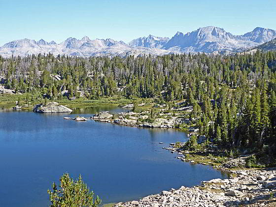
As you climb enjoy amazing vistas of the high peaks in the northern Wind River Range viewed from Photographer’s point. At 6.1 miles reach the northwest end of the first Top Lake, nestled amid granite knolls and rock outcroppings. Skirt the lake’s western shore. Soon you will arrive at the second Top Lake. Here the trail turns left (east) and traverses the lake’s north shore. Past the second lake the trail travels through scattered trees and meadows. At 6.5 mile views open to pretty Marys Lake to the south. Nice campsites are located in the trees around Marys and the Top Lakes.
At 6.7 miles the trail curves to the right (southeast) and starts descending on easy to moderate grades through trees and meadows, crossing a stream and skirting the south side of a small tarn along the way. Openings in the trees offer views of Angel Peak (12,402-ft.) and Angel Pass to the east.
The grade eases at 7.4 miles as the path traverses the timbered fringe along the southwest side of an elongated lake. Ahead views open to Mount Baldy (11,857-ft.).
At the south end of the lake the trail descends to a marshy meadow with a small pond at 7.8 miles and then swings to the left (east/northeast). The path now follows an undulating course, descending toward the Pole Lakes through a landscape of meadows and scattered trees growing amid granite knolls and rock outcroppings. At 8.5 miles the trail traverses the north side of a marshy meadows and then swings around the south side of a small tarn.
At 8.7 miles, just beyond the tarn, the trail descends switchbacks on moderate grades through trees to a creek crossing, which may be dry late in the season. On the west side of the creek the trail curve to the right (southeast) and continues descending a rocky trail along the west side of a draw to a crossing of Monument Creek at 9.4 miles.
Beyond the crossing the trail climbs over a knoll and reaches a junction with the Highline Trail at 9.7 miles. Here the Pole Creek trail ends. We turn left (northeast) on the Highline trail headed toward the Cook Lakes. The Highline Trail branching right (south) leads to the to some well used campsites along the east side of largest of the Pole Lakes and then continues on to the Chain Lakes. (Note you will need to wade across Pole Creek to reach the camping area.)
Highline Trail to the Cook Lakes Junctions
A short distance past the junction, reach a wide crossing of Pole Creek at 9.8 miles. Above the crossing a pretty waterfalls cascades down a crevasse along the creek.
Wade across the stream, which is typically knee to shin deep depending on the time of year. Climb a low hill on the southeast side of the creek and then follow the trail as it swings around a wet meadow. The trail now ascends northeast on easy grades through meadows and over rock outcroppings to the southeast of Pole Creek. This is a beautiful area where the creek flows through a series of small ponds. Nice campsites are found amid the basin’s trees and small meadows.
At 10.4 miles the path starts climbing steep switchbacks up a rocky, timber-clad hillside. At the top of the ridge the summits of the peaks rising to the northeast are seen through openings in the trees.
The trail now descends on moderate grades and then skirts the east side of a meadow before climbing over a low knoll to the eastern shore of a pretty pond at 10.9 miles. Here views extending northeast toward Mt. Lester (12,342-ft.) and the high peaks at the head of the Pole Creek Valley.
Beyond the pond the trail descends a narrow draw and then swings around the east side of a small pond, crossing a small stream along the way. A traverse along the west side of a second pond leads to a confusing, unmarked junction at the middle crossing of Pole Creek at 11.2 miles. Here two trails that climb to junctions with the Fremont Trail and Highline Trail:
1. The Highline to the Fremont Trail/Cook Lakes East Access
If you are heading south on the Fremont trail or visiting the east side of the Cook Lakes and the Wall Lake area, bear right (east) at the junction and continue up the east side of Pole Creek to a junction with the Fremont Trail. A brief stint along the south side of Pole Creek leads to a steep rocky trail that swings around the south side of a rock knob. As you climb, enjoy views of a waterfall cascading down Pole Creek’s rocky bed.
Beyond the knob the trail travels on easy grades to a trail junction at 11.7 miles. Here the Fremont turns right (southeast) toward the Baldy Lakes. The Highline trail turns left (north/northwest) toward Lester Pass. To reach the eastern access to the Cook Lakes, turn right on the Fremont Trail. Soon you will reach a second signed junction with a trail branching left (north/northeast) toward the Cook Lakes.
2. The Highline North Cutoff Trail to the Highline/Cook Lakes West Access
If you are heading north on the Highline Trail toward Lester Pass or visiting the west side of the Cook Lakes area, turn left (north) and wade across Pole Creek. The middle crossing of the creek is wider than the upper crossing and is not quite as deep.
On the north side of the creek the trail traverses the west side of a pond. Beyond the pond the path crosses the pond's inlet stream and then climbs on easy and then moderate grades up the west side of a draw to a trail junction at 11.7 miles. Turn left (northwest) to stay on the Highline Trail heading toward Lester Pass. Straight ahead is the use trail climb the west side of the Cook Lakes. To the right (southwest) is the Highline Trail leading to the upper Pole Creek crossing and the beginning of the Fremont Trail.
Return to Introduction: Cook - Island Lakes Loop
Go To Segment 2: Cook and Wall Lakes
Elevation Profile
Backpack Segments
- Introduction: Cook - Island Lakes Loop
- Segment 1: Pole Creek and Highline Trails to Cook Lake Junctions
- Segment 2: Cook and Wall Lakes
- Segment 3: Pole Creek to Little Seneca Lake via Lester Pass
- Segment 4: Little Seneca Lake to Island Lake
- --- Side Trip: Titcomb Basin
- --- Side Trip: Indian Basin and Pass
- --- Side Trip: Island Lake Waterfall Day Hike
- Segment 5: Island Lake to Elkhart Park
Driving Directions to Elkhart Park Trailhead
Directions from Pinedale: From the intersection of Pine Street (US 191) and North Tyler Ave (the Pinedale Tourism office is located on the northeast corner) in Pinedale, WY, drive east on Highway 191 (East Pine Street) for 0.3 miles and bear left onto Fremont Lake Road. Follow this road for 14.3 miles and turn right into the large parking area for the Elkhart Park/Pole Creek Trailhead. After the first 3.0 miles the road will turn into Skyline Drive/Forest Service Road 370740. The trailhead is located at the northeast end of the parking lot between the outhouse and the trailhead kiosk. It should take about 25 minutes to drive the trailhead. The last section of the road has some holes and uneven spots.
Trail Resources
- Backpack Intro
- Segment Photo Gallery
- Segment Map
- Trailhead(s) Information: Elkhart Park
- Region Information: Wyoming's Wind River Range
- Other Hiking Regions in: Wyoming