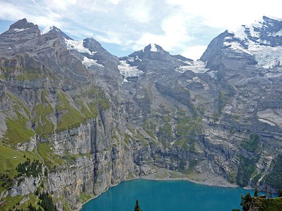
Great views of the peaks forming the cirque above the Oeschinensee
This terrific loop hike features ever-evolving views of the magnificent glacial cirque towering above the Oeschinensee, one of the most beautiful lakes in the Swiss Alps.
See Trail Detail/Full Description
- Distance: 2.5 miles (one way) to Ober Bergli
5.2 miles (loop) to Complete Loop - Elevation: 5,530-ft. at Trailhead
6,473-ft. at Ober Bergli
6,588-ft. at Complete Loop - Elevation Gain: 943-ft. to Ober Bergli
1,395-ft. to Complete Loop - Difficulty: moderate
- More Hikes in:
Kandersteg / The Bernese Oberland
Why Hike Oeschinensee Loop
The Oeschinensee, one of the most beautiful lakes in the Swiss Alps, lies nestled beneath the sheer cliffs and rugged flanks of a stunning cirque of 3,000-meter peaks. Glaciers, clinging to the peak’s upper slopes, spawn streams coalescing into waterfalls that tumble into the lake. This great loop hike offers wonderful views of the Oeschinensee and the glacial cirque, anchored by the Bluemlisalp, Oeschinenhorn, Frundenhorn and Doldenhorn, from a variety of different perspectives.
The day starts with a scenic gondola ride from Kandersteg to the eastern end of the hanging valley cradling the Oeschinensee. A half-hour walk through pretty meadows and pine forests leads to the lakeshore where great views open to the magnificent wall of peaks encircling the pristine lake.
From the lakeshore, a scenic trail ascends along the north side of the lake, crosses the inlet stream and then climbs steeply to the small alp of Ober Bergli. Views along the way encompass the high peaks towering above the south and east sides of the lake. At the alp the trail turns northwest and then west, contouring high above the north side of the lake.
From the high trail views extend east up the valley to Hohturli pass and the Bluemlisalp massif. The Bluemlisalp glacier tumbles down the slopes between the Bluemlisalp-Rothorn, Ufem Stock and Wyssi Frau, rugged horns protruding from the flanks of the Bluemlisalp massif. To the south the Oeschinenhorn, Frundenhorn and Doldenhorn soar above the Oeschinensee. Glaciers, tumbling down the rugged slopes beneath the peaks, and waterfalls, fed by glacial meltwater, glisten in the sun.
Near the northwest end of the lake the trail drops down to and joins the trail to the gondola station. Hikers can either return to Kandersteg via the gondola or walk down to Kandersteg following a pleasant trail that descends along the Oschibach, the outlet stream for the Oeschinensee.
The trail can be hiked in either direction. I personally prefer walking in the clockwise direction, taking the higher trail first and then returning along the lake shore. Others prefer the counter-clockwise direction as described in the trail detail below. Either option offers amazing views of this stunningly beautiful location.
Elevation Profile

| Support our Site |
Trail Resources
Trail Detail/Full Description / Trail Photo Gallery / Trail Map
Basecamp(s) Information:
Kandersteg
Region Information:
The Bernese Oberland
Other Hiking Regions in:
Switzerland