Hike Facts
- Distance: 5.2 miles (loop)
- Elevation: 5,530-ft. - 6,588-ft.
- Elevation Gain: 943-ft. - 1,395-ft.
- Difficulty: moderate
- Trail Highlights: See Trail Intro
- Basecamp(s): Kandersteg
- Region: The Bernese Oberland
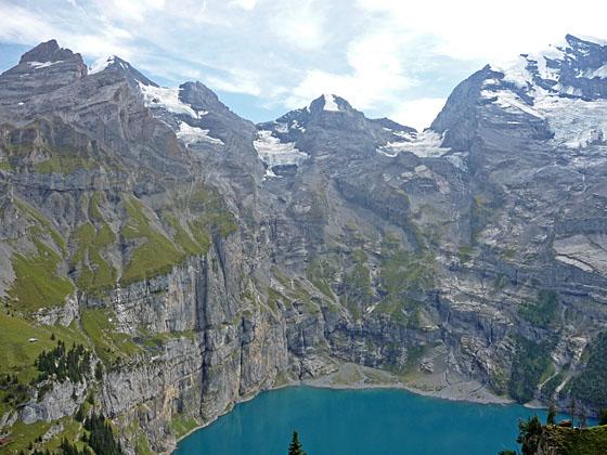
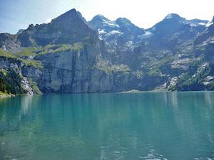
This terrific loop hike features ever-evolving views of the magnificent glacial cirque towering above the Oeschinensee, one of the most beautiful lakes in the Swiss Alps.
Ober Bergli
Distance from Trailhead: 2.5 miles (one way)
Ending/Highest Elevation: 6,473-ft.
Elevation Gain: 943-ft.
From Kandersteg, take the Kandersteg-Oeschinensee Gondola to the top station (5,530-ft.). (See trailhead directions below.) Exit the gondola station and find the hiking signs at the start of a gravel path heading east. Views from the meadows adjacent to the gondola offer previews of the coming attractions. The Oeschinenhorn, Frundenhorn and Doldenhorn fill the skyline to the east/southeast while the Bunderspitz and the Gross Lohner dominate the view to the southwest.
Walk east along the gravel path toward the Oeschinensee. In a short distance reach a “Y” intersection at Schatthaus (5,479-ft.) and take the trail branching left toward Lager, the Oeschinensee (20-min) and Hohturli (4-hr). Follow the trail as it heads east through meadows and clusters of trees, passing a few minor junctions. In all cases continue along the main trail toward Lager and the Oeschinensee.
Reach a junction at 0.6 miles with a trail branching left toward Heuberg, Ober Bergli, Hohturli and Bluemlisalphutte. This is our return route. We continue straight ahead toward Lager and the Oeschinensee. The trail now descends on easy grades to Lager (5,443-ft.) and a trail junction at 0.9 miles. Turn left at the junction toward the Oeschinensee and Hohturli.
The path soon crosses a stream and then travels through trees above the northwest end of the lake to Chuematti (5,217-ft.) at 1.1 miles. Here a trail drops down to the lake. Take a brief detour to visit the lakeshore and enjoy the great views of the sheer walls and rugged peaks forming the stunning glacial cirque ringing the Oeschinensee. At the eastern end of the lake a waterfall cascades down rock ledges into the lake.
When you are done soaking in the views return to Chuematti and walk east/northeast toward Ober Bergli (1-hr 20-min) on a broad gravel track along the north side of the lake. The path ascends on moderately steep grades through clusters of trees and small meadows beneath a rugged hillside, passing a pretty waterfall plunging down a sheer cliff face at 1.3 miles.
At 1.5 miles the grade abates as the trail contours along the base of a cliff with great views of the peaks towering above the east and south sides of the lake, including the Oeschinenhorn, Frundenhorn and Doldenhorn. Waterfalls, fed by glacial meltwater, spill down the steep flanks of the peaks to the lake. Beyond the cliff the trail climbs on easy grades through meadows, crossing two more streams along the way.
Cross a bridge over the stream draining the Bluemlisalp/Hohturli Pass area at 1.9 miles. The trail now curves to the left (northeast), ascending on very steep grades up the rocky meadows beneath the lake’s headwall. Ignore any trails branching right toward the buildings of Unter Bergli.
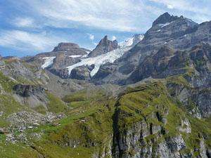
Reach Ober Bergli (6,473-ft.), at the foot of a small hanging valley high above the northeast side of the Oeschinensee, and a trail junction at 2.5 miles. From the alp views extend east/northeast to the Bluemlisalp massif, the Wyssi Frau and the Bluemlisalp Glacier.
At this point you have a few choices. You can wander up valley toward Hohturli Pass, retrace your steps to Lager and the gondola for a 5.0 mile round-trip hike or continue the loop hike. To continue the loop, turn left (northeast) at the junction toward Heuber, Lager (1-hr) and Kandersteg (2-hr 10-min), on a trail contouring high above the north side of the lake.
Completing the Loop
Distance from Trailhead: 5.2 miles (loop)
Ending/Highest Elevation: 6,588-ft.
Elevation Gain: 1,395-ft.
Follow the trail as it crosses to the north side of the stream and starts traversing high above the northeast end of the lake. At 2.7 miles great views reopen to the Doldenhorn towering above the Oeschinensee. Soon the Frundenhorn joins the scene. Glaciers tumble down the rugged slopes beneath the peaks. Waterfalls, fed by glacial melt water, cascade down the peak's sheer walls into the lake.
The narrow trail now winds through meadows, crosses rockslide and navigates rocky gullies along the valley’s steep, sinuous walls, high above the north side of the lake. Caution is required in a few spots with a little bit of exposure.
Turn around for great views that extend up the valley to Hohturli pass. The Bluemlisalp Glacier tumbles down the slopes between the Bluemlisalp-Rothorn, Ufem Stock and Wyssi Frau, rugged horns protruding from the flanks of the Bluemlisalp massif.
At 3.6 miles a grassy knoll with a bench beckons hikers to stop and soak in the sublime views. You now have a great perspective of the amazing sheer walls ringing the Oeschinensee along with the rugged peaks forming the stunning glacial cirque surrounding the lake.
Beyond the knoll the trail descends on steep to moderately-steep grades through meadows and groves of evergreens, crossing a few talus slopes along the way. At 4.6 miles the path reaches the junction with the gravel track leading back to the gondola. Turn right (west) to take the broad track toward the gondola to Kandersteg. Turn left (east) to walk down to Kandersteg.
To take the gondola to Kandersteg, walk west along the gravel track, following signs directing you to the bergstation (top of the gondola). Reach the gondola’s bergstation (5,530-ft.) at 5.2 miles.
If you prefer to walk down to Kandersteg take the trail to the left (east/southeast), which descends steeply along the Oschibach, a pleasant stream with nice views of the steep walls lining the south side of the valley. Reach Kandersteg (3,858-ft.) after hiking about 3.0 miles and losing over 1,600-ft. from the junction. Total hiking distance for the loop around the lake, taking the gondola up and walking down to Kandersteg is 7.6 miles.
There is also a trail to Kandersteg that starts at the top of the gondola and drops down steep switchbacks beneath the gondola. The trail that descends along the Oschibach is the better option.
Note: The trail can be hiked in either direction. I personally prefer walking in the clockwise direction, taking the higher trail first and then returning along the lake shore. (Read the first part of the Hohturli Pass hike to Ober Bergli. From Ober Bergli reverse the directions above and descend to the Oeschinensee.) Others prefer the counter-clockwise direction as described in the trail detail below. Either option offers amazing views of this stunningly beautiful location.
Elevation Profile

Driving Directions
From the Kandersteg Bahnhof (train station) to the Kandersteg-Oeschinensee Gondola: From the front of the train station, walk south a short distance and turn left (east) onto Bahnhofstrasse (Train Station Street). Walk about 700-ft. east on Bahnhofstrasse and turn left (north) on Dorfstrasse (the town’s main street). Walk about 650-ft. along Dorfstrasse, passing two streets on the right. Just before the second street you'll go by the Kandersteg Tourism Office on your right, a good place to stop to pickup maps and town information.
A short distance beyond the second street, turn right on a paved walkway heading east through beautiful meadows. The Hotel Bernerhof is directly across from the meadow. Walk a little over 0.3 miles on the pavement to Oschistrasse, passing a pretty little chapel on your right along the way. Turn left on Oschistrasse and walk about 360-ft. to the Kandersteg-Oeschinensee Gondelbahn (gondola). The gondola ride to the top station takes about nine minutes.
See Kandersteg-Oeschinensee Gondelbahn website for the current schedule.
Trail Resources
Trail Intro / Trail Photo Gallery / Trail Map
Basecamp(s) Information:
Kandersteg
Region Information:
The Bernese Oberland
Other Hiking Regions in:
Switzerland