Backpack: Big Sandy to Elkhart Park via Fremont and Highline Trails
Side Trip: Cook and Wall Lakes
Distance: 1.3 - 3.8 miles (one way)
Bridger Wilderness, Bridger-Teton National Forest, near Big Sandy in Wyoming's Wind River Range
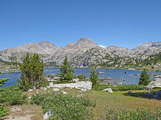
Upper Cook Lake
- Distance: 1.3 - 3.8 miles
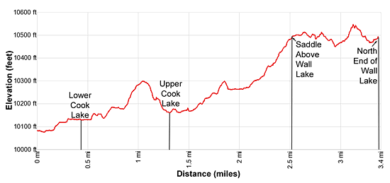
- Elevation: 10,070-ft at Junction with Cook Lake trail
10,143-ft. at Lower Cook Lake
10,170-ft. at Upper Cook Lake
10,440-ft. at Saddle above Wall Lake
10,470-ft. near the head of Wall Lake - Difficulty: moderate-strenuous
- Basecamp: Big Sandy
- Region: Wyoming's Wind River Range
Cook and Wall Lakes Description
I highly recommend the side trip to the Cook Lakes, situated in a scenic basin amid a backdrop of Mount Lester (12,342-ft.) and the high summits rising above the upper Pole Creek Valley. Beyond the upper lake a use-trail leads to an overlook above the south end of photogenic Wall Lake, set beneath the soaring granite slopes of an unnamed peak to the west. From the overlook a route travels above the lake’s eastern shores to the head of the lake and the spectacular upper Pole Creek Valley.
This trail segment starts at the junction of the Fremont and Cook Lakes trail, just to the southwest of the upper Pole Creek crossing on the Highline Trail. To visit Cook and Wall Lakes turn east/northeast at the junction and follow the trail as it ascends along the east side of the Cook Lakes valley. (There is a second Cook Lakes trail that climbs along the west side of the valley.)
The Cook Lakes trail is initially faint but soon becomes better defined. From the junction the trail heads east, skirting the south side of a rock outcropping. It then curves to the left (northeast), ascending on easy grades through meadows scattered with willow thickets and trees to the east of Pole Creek. The path becomes difficult to follow in places as it passes through clusters of thick willows.
At 0.3 miles the trail reaches Pole Creek, just to the south of where the creek flows out of a pretty pond. The trail now curves around the south/southeast side of the pond where views open to Mt. Lester, Ellingwood (Harrower) Peak (13,052-ft.), Faler Tower (12,607-ft.) and a host of summits rising to the north/northwest.
At 0.4 miles the trail reaches a creek crossing at the south end of Lower Cook Lake (10,143-ft.). Rock-hop across the creek or, in periods of high water, wade the creek. Beyond the crossing the trail follows an undulating course above the east side of the lake. Along the way enjoy more great views of the peaks rising to the north.
Past the lake the trail climbs a low rise and then travels through a small basin with a few tarns. Campsites can be found amongst the knobs and trees surrounding the basin.
At 0.8 miles the trail starts climbing on moderate grades up a timber-clad ridge separating the Lower and Upper lakes. Drop down the far side of the ridge on moderately steep grades to a sandy knoll near the southeast end of Upper Cook Lake (10,170-ft) at 1.3 miles. From this viewpoint Mt. Lester, Harrower (aka Ellingword) Peak and a numbers of unnamed summits form the scenic backdrop for the gorgeous upper lake. To the east the rugged cliffs of Peak 12,476 and Peak 12,529 tower above the lake. Use trails, branching off the main trail, lead to campsites above the lake’s southern and western shores.
Upper Cook Lake to Wall Lake
A trip to Wall Lake from Upper Cook Lake is well worthwhile. From the south end of the lake follow a well-defined use trail that swings around the southeast end of the lake and then heads north along the east side of the lake. The path can be hard to follow as it travels through moist meadows littered with willows and crosses a few small streams. The best bet is to find and follow the trail traveling near the lakeshore along the right (east) side of some rock outcroppings.
At 1.5 miles the trail starts climbing on easy to moderate grades, crossing a creek at 1.6 miles. To the east a waterfall spills down the rugged slopes above the trail. Beyond the crossing the trail swings away from the lake and soon ascends a knoll.
At 1.8 miles reach the top of a knoll. A short descent leads to a beautiful little valley clad in emerald green meadows. A small stream meanders down the valley floor. A boot beaten path now ascends on easy grades along the east side of the valley. Be sure to turn around at this point to identify some landmarks so you know where to climb out of the valley on the return trip.
At 2.1 miles, just before reaching a rock outcropping, the valley constricts and the trail reaches a creek crossing. Rock-hop across the creek. On the west side of the creek you will join a trail traveling up the west side of the draw. You can return using either trail. (The trail along the west side of the draw fades near the foot of the valley as it reaches boggy meadows.)
The trail now ascends the west side of the valley, climbing through meadows and across sections of slickrock marked with rock cairns. At 2.2 miles the trail begins following a cairned route that climbs a slickrock slope. As the trail climbs is curves to the northwest.
Reach a saddle on a divide at 2.5 miles. A small pond lies nestled in the slickrock atop the divide. As you cross the divide views open to beautiful Wall Lake. The steep granite slopes of unnamed peak tower above the lake’s impassable western shore.
You are now near the southern end of the narrow lake, which stretches north for over a mile and a half. From the divide travel through meadows and across granite slabs toward the lakeshore, heading northwest and then north along the east side of the lake. There is no defined route, simply pick the path of least resistance across the granite slabs above the lake.
At 2.9 miles the granite gives way to meadow clad draw (drainage). Drop down the south side of the draw. As you near the lakeshore you will see a good place to cross the stream trickling down the draw. At this point you should be able to look ahead and see a boot beaten path ascending through the rocky meadows on the north side of the draw. Follow the trail as it climbs out of the draw and ascends an undulating course along the base of a cliff.
At 3.1 miles watch for rock cairns marking a route that turns right, climbs up slabs and then briefly travels along an exposed slickrock slope. The exposed section of the trail is short and soon leads to a cairned route that drops down granite slopes to willow-choked meadows near the north end of the lake. (Note: The climb over the granite slope is necessary to avoid steep granite cliffs that preclude further travel along the lakeshore.)
Views to the north are sublime. Faler Tower and Ellingwood (Harrower) Peak tower above the westerns side of the upper Pole Creek valley. Massive granite cliffs along the Continental Divide rim the east side of the valley. A route continues north along the lake’s eastern shore for 0.7 miles and then crosses the lake’s inlet stream below a small lake at 3.8 miles.
This crossing is a good turn around point for parties on a day hike from the Cook Lakes. Beyond the crossing, a route turns northwest and climbs to an 11,200-ft. pass separating Wall Lake and Island Lake. Snowfields often cover the upper section of the route to the pass. From the pass a boot-beaten path drops down the valley between Elephant Head and Mt. Lester to the eastern end of Island Lake. (From the northern end of Wall Lake to Island Lake is about 3.0 miles.)
Alternatively, it is possible to explore further north up the amazing upper Pole Creek Valley.
Return to Segment 7: Bell Lakes Junction to Pole Creek
Go To Segment 8: Pole Creek to Little Seneca Lake
Elevation Profile
Backpack Segments
- Introduction: Big Sandy to Elkhart Park via Fremont and Highline Trails
- Segment 1: Big Sandy to Marms Lake
- Segment 2: Marms Lake to Raid Lake
- --- Side Trip: Bonneville Lakes
- Segment 3: Raid Lake to Middle Fork Junction above Sandpoint Lake
- --- Side Trip: Middle Fork Lake Trail
- --- Side Trip: Middle Fork Lake via the Rainbow Lake Trail
- --- Side Trip: Photo Pass Trail
- Segment 4: Sandpoint Lake to Valley Lake Junction
- --- Side Trip: Europe Canyon and Pass
- Segment 5: Valley Lake Junction to North Fork Lake
- --- Side Trip: Hay Pass, the Golden Lakes and Fall Creek Pass
- Segment 6: North Fork Lake to Bell Lakes Junction
- Segment 7: Bell Lakes Junction to Pole Creek
- --- Side Trip: Cook and Wall Lakes
- Segment 8: Pole Creek to Little Seneca Lake
- Segment 9: Little Seneca Lake to Island Lake
- --- Side Trip: Titcomb Basin
- --- Side Trip: Indian Basin and Pass
- --- Side Trip: Island Lake Waterfall Hike
- Segment 10: Island Lake to Elkhart Park
Driving Directions to Elkhart Park Trailhead
Big Sandy Trailhead: This popular trailhead is located in the southern Wind River Range next to the Big Sandy River.
Directions from Pinedale: From the intersection of Pine Street (US 191) and North Tyler Ave (the Pinedale Tourism office is located on the northeast corner) in Pinedale, WY, drive south on Highway 191 for 11.7 miles and then turn left (east) on WY-353. After 15.5 miles you will notice signs referring to the road as the Big Sandy-Elkhorn Road and after 18 miles the paved road will change to a good packed dirt/gravel surface.
Shortly after the pavement ends go straight through a junction, and drive south crossing the Big Sandy River (Buckskin Crossing). Follow the road for a total of 27.3 miles. Shortly after crossing the Big Sandy River you will reach a junction with the Lander Cutoff Road (the next junction). Turn left on the Lander Cutoff Road. There is a wood sign at the intersection pointing toward the Big Sandy trailhead.
Drive 7.0 miles on the Lander Cutoff Road and then turn left on the Big Sandy Opening Road. Here you will see a sign for the Big Sandy Campground and trailhead. The road now deteriorates and narrows. Blind corners and lush foliage along the road make it hard to see ahead. Drive carefully, following the rocky, rutted road for 9.8 miles to a "Y" intersection. Bear right at the intersection to continue along the Big Sandy Opening Road (Forest Service Road 850). (The road branching to the left leads to the Big Sandy Lodge and Mud Lake.) Follow the road for 0.8 miles to the trailhead parking area, equipped with an outhouse.
Allow an hour and a half to reach the trailhead from Pinedale. The parking area is too small for the number of backpackers visiting the area during the height of the summer. If the parking area is full, find a safe place to park off the access road.
I recommend a high clearance vehicle to reach the trailhead. Passenger cars can make it OK if driven carefully. Check at the Pinedale ranger station before starting your trip to learn about current road and trail conditions. The Ranger Station is located to the east of the Ridleys Grocery Store on US 191 (Pine Street in Pinedale). The entrance to the ranger station is on the Fremont Lake Road. (You can also reach the parking area for the ranger station by driving east through the Ridley’s parking lot.)
This trailhead is remote, so be sure to have a full tank of gas. The dirt road become slippery when wet. The campground at the parking area is tiny, with only 4 sites. I would not plan on camping at the trailhead before starting your backpack.
Elkhart Park Trailhead: From the intersection of Pine Street (US 191) and North Tyler Ave (the Pinedale Tourism office is located on the northeast corner) in Pinedale, WY, drive east on Highway 191 (East Pine Street) for 0.3 miles and bear left onto Fremont Lake Road. Follow this road for 14.3 miles and turn right into the large parking area for the Elkhart Park/Pole Creek Trailhead. After the first 3.0 miles the road will turn into Skyline Drive/Forest Service Road 370740. The trailhead is located at the northeast end of the parking lot between the outhouse and the trailhead kiosk. It should take about 25 minutes to drive the trailhead. The last section of the road has some holes and uneven spots.
Trail Resources
- Backpack Intro
- Segment Photo Gallery
- Segment Map
- Trailhead(s) Information: Big Sandy
- Region Information: Wyoming's Wind River Range
- Other Hiking Regions in: Wyoming