Backpack: Big Sandy to Elkhart Park via Fremont and Highline Trails
Side Trip: Indian Basin and Pass
Distance: 10.4 miles (round trip)
Bridger Wilderness, Bridger-Teton National Forest, near Big Sandy in Wyoming's Wind River Range
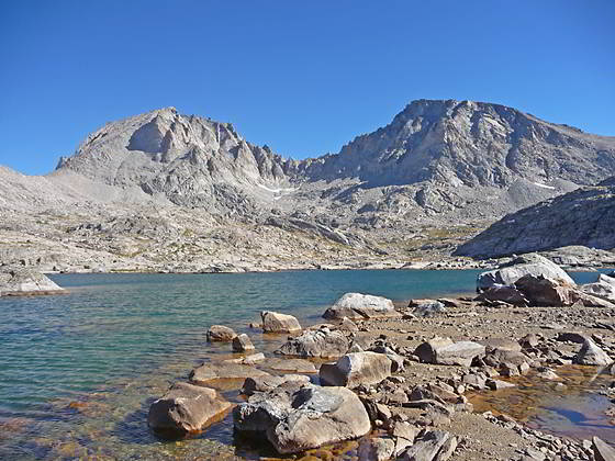
Fremont and Jackson Peaks from Indian Basin Lake
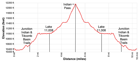
- Distance: 10.4 miles
- Elevation: 10,410-ft. at Island Lake
10,545-ft. at junction Indian and Titcomb Basin trails
11,008-ft. at Lake 11,008
12,120-ft. at Indian Pass - Difficulty: strenuous
- Basecamp: Big Sandy
- Region: Wyoming's Wind River Range
Indian Basin and Pass Description
This hike starts from at the unmarked junction at the southeast end of Island Lake (10,346-ft.). The use trail to the left (northwest) leads to campsites along the lake’s southwestern shore. The trail straight ahead (northeast) is the Indian Pass trail.
Follow the Indian Pass trail as it skirts the eastern shore of Island Lake. Along the way enjoy fine views of the summits towering above Titcomb Basin to the north. Elbow (11,948-ft.) and Sky Pilot (12,129-ft.) peaks rise in the distance to the northwest.
Pass an unmarked trail/route at 0.3 miles climbing to Pass 11,120, a saddle on the ridge between the Island and Wall Lake basins. Soon our trail curves to the left (northwest) around the northeast end of the lake and starts climbing.
At 0.7 miles the path curves to the right northeast and ascends the north side of a draw to a saddle on a low ridge at 0.9 miles. Atop the ridge are more great views of the summits of Titcomb Basin.
The trail now descends through meadows into a pretty basin cradling Lake 10,467. Pass above the lake’s eastern shore and then climb around a minor ridge at the northeast end of the lake, paralleling the lake’s inlet stream, the creek draining Indian Basin.
Reach the junction of the Indian Pass and Titcomb Basin trails at 1.2 miles. The Titcomb Basin trail continues straight ahead (north). We turn right (northeast) on the Indian Pass trail.
The trail briefly ascends along the south side of the creek and then crosses the stream at 1.3 miles by hopping across the large boulders that litter the creek bed. Rock cairns mark the crossing points on both sides. On the north side of the creek the trail continues the ascent through rocky meadows and willow thickets.
At 1.5 miles the trail ascends a draw on moderate to moderately-steep grades. Reach the top of the draw at 2.0 miles and enters gorgeous Indian Basin. Here the grade abates and great views open to Fremont Peak (13,745-ft.) and Jackson Peak (13,517-ft.) rising to the north. The trail now travels on easy grades through a landscape of small meadows growing amid granite slabs, rock outcropping and boulders.
Cross the creek draining an unnamed lake, referred to by some as Indian Basin Lake, at 2.2 miles and then travel along the lake’s southeast shore. To the east views open to Ellingwood (Harrower) Peak (13,052-ft.) towering above Lake 10,813, nestled in the basin below the trail. Continue along the trail that is funneled between the lake’s eastern shore and granite knolls. Exposed, albeit scenic, campsites are located on the north side of the lake and on the isthmus separating the lake’s two northern arms.
Beyond Indian Basin Lake the trail crosses the creek again at 3.0 miles and soon arrives at the western shore of Lake 11,008. The trail now curves to the north as it traverses the lake’s western shore. A few campsites are located on the north side of the lake.
At the head of Lake 11,008 the trail starts climbing on moderate grades. As you ascend enjoy great views of the jagged crags along the south facing slopes of Fremont and Jackson Peaks. Turn around for good views of Ellingwood (Harrower) Peak, Elephant Head and Lake 11,008.
At 3.5 miles the trail crosses a small creek and then curves to the right (east), winding its way up rocky meadows and navigating around rock outcroppings beneath the south face of Jackson Peak. As you gain elevation fine views open to the lake basin you just traversed. Ahead the serrated profile of Knife Point Ridge rises above a saddle on the ridge extending northeast from Peak 11,974.
The grade abates at 4.1 miles as the trail enters a tiny basin and passes to the south of a small lake. Beyond the lake the path arcs around soggy meadows and then starts climbing up steep rocky slopes at 4.4 miles. Along the way pass a stream tumbling down a rugged cliff face to the north of the trail.
At 4.7 miles the trail curves to the left (northeast) and begins the final stiff climb through talus fields to Indian Pass. The pass, a small saddle between Knifepoint Ridge and Peak 12,876 is now visible. To the south Ellingwood Peak and Notch Pinnacle tower above the rugged basin. The Harrower Glacier spills down the slopes beneath Knifepoint Ridge and Notch Pinnacle.
Reach Indian Pass (11,120-ft.) at 5.2 miles. As you crest the saddle views open northeast to the North Fork Bull Lake Valley. The sheer cliffs along Horse Ridge, the Ranger and Dry Creek Ridge rim the valley to the north. The gap in this ridge is also called Indian Pass. Below the northeast side of the pass are the remains of the Knifepoint Glacier. Don’t try to cross the snow and ice unless you are properly equipped with crampon and an ice axe. To the south/southwest are more great views of Notch Pinnacle, Ellingwood Peak, the Harrower Glacier, Elephant Head and, in the distance, Mount Lester (12,342-ft.). The jagged pinnacles and towers of Knifepoint ridge rear above the pass.
When you are done taking in the fine views, retrace your steps back to Island Lake.
Return to Segment 9: Little Seneca Lake to Island Lake
Go To Segment 10: Island Lake to Elkhart Park
Elevation Profile
Backpack Segments
- Introduction: Big Sandy to Elkhart Park via Fremont and Highline Trails
- Segment 1: Big Sandy to Marms Lake
- Segment 2: Marms Lake to Raid Lake
- --- Side Trip: Bonneville Lakes
- Segment 3: Raid Lake to Middle Fork Junction above Sandpoint Lake
- --- Side Trip: Middle Fork Lake Trail
- --- Side Trip: Middle Fork Lake via the Rainbow Lake Trail
- --- Side Trip: Photo Pass Trail
- Segment 4: Sandpoint Lake to Valley Lake Junction
- --- Side Trip: Europe Canyon and Pass
- Segment 5: Valley Lake Junction to North Fork Lake
- --- Side Trip: Hay Pass, the Golden Lakes and Fall Creek Pass
- Segment 6: North Fork Lake to Bell Lakes Junction
- Segment 7: Bell Lakes Junction to Pole Creek
- --- Side Trip: Cook and Wall Lakes
- Segment 8: Pole Creek to Little Seneca Lake
- Segment 9: Little Seneca Lake to Island Lake
- --- Side Trip: Titcomb Basin
- --- Side Trip: Indian Basin and Pass
- --- Side Trip: Island Lake Waterfall Hike
- Segment 10: Island Lake to Elkhart Park
Driving Directions to Elkhart Park Trailhead
Big Sandy Trailhead: This popular trailhead is located in the southern Wind River Range next to the Big Sandy River.
Directions from Pinedale: From the intersection of Pine Street (US 191) and North Tyler Ave (the Pinedale Tourism office is located on the northeast corner) in Pinedale, WY, drive south on Highway 191 for 11.7 miles and then turn left (east) on WY-353. After 15.5 miles you will notice signs referring to the road as the Big Sandy-Elkhorn Road and after 18 miles the paved road will change to a good packed dirt/gravel surface.
Shortly after the pavement ends go straight through a junction, and drive south crossing the Big Sandy River (Buckskin Crossing). Follow the road for a total of 27.3 miles. Shortly after crossing the Big Sandy River you will reach a junction with the Lander Cutoff Road (the next junction). Turn left on the Lander Cutoff Road. There is a wood sign at the intersection pointing toward the Big Sandy trailhead.
Drive 7.0 miles on the Lander Cutoff Road and then turn left on the Big Sandy Opening Road. Here you will see a sign for the Big Sandy Campground and trailhead. The road now deteriorates and narrows. Blind corners and lush foliage along the road make it hard to see ahead. Drive carefully, following the rocky, rutted road for 9.8 miles to a "Y" intersection. Bear right at the intersection to continue along the Big Sandy Opening Road (Forest Service Road 850). (The road branching to the left leads to the Big Sandy Lodge and Mud Lake.) Follow the road for 0.8 miles to the trailhead parking area, equipped with an outhouse.
Allow an hour and a half to reach the trailhead from Pinedale. The parking area is too small for the number of backpackers visiting the area during the height of the summer. If the parking area is full, find a safe place to park off the access road.
I recommend a high clearance vehicle to reach the trailhead. Passenger cars can make it OK if driven carefully. Check at the Pinedale ranger station before starting your trip to learn about current road and trail conditions. The Ranger Station is located to the east of the Ridleys Grocery Store on US 191 (Pine Street in Pinedale). The entrance to the ranger station is on the Fremont Lake Road. (You can also reach the parking area for the ranger station by driving east through the Ridley’s parking lot.)
This trailhead is remote, so be sure to have a full tank of gas. The dirt road become slippery when wet. The campground at the parking area is tiny, with only 4 sites. I would not plan on camping at the trailhead before starting your backpack.
Elkhart Park Trailhead: From the intersection of Pine Street (US 191) and North Tyler Ave (the Pinedale Tourism office is located on the northeast corner) in Pinedale, WY, drive east on Highway 191 (East Pine Street) for 0.3 miles and bear left onto Fremont Lake Road. Follow this road for 14.3 miles and turn right into the large parking area for the Elkhart Park/Pole Creek Trailhead. After the first 3.0 miles the road will turn into Skyline Drive/Forest Service Road 370740. The trailhead is located at the northeast end of the parking lot between the outhouse and the trailhead kiosk. It should take about 25 minutes to drive the trailhead. The last section of the road has some holes and uneven spots.
Trail Resources
- Backpack Intro
- Segment Photo Gallery
- Segment Map
- Trailhead(s) Information: Big Sandy
- Region Information: Wyoming's Wind River Range
- Other Hiking Regions in: Wyoming